Friday, May 25, 2018

Devils Canyon, Bluff, Utah and the Big 4 Tractor

May 13-14, 2018:

In one of our shortest moves, we left Blanding and traveled 11 miles north on route 191 to Devil’s Canyon Campground.  The address is Manti-Lasal, Utah although there is no sign of a town here, but is in the edge of the Manti-Lasal National Forest.  It’s a nice inexpensive dry campsite in a forest setting, but not exactly the Devil’s Canyon we were expecting.  We had seen photos of a Devil’s Canyon with lots of trails and slot canyons and thought this was it, but it’s not !  It seems there are two Devil’s Canyons and the one located another eighty mils to the north is the one with the devil like terrain.  It’s no big deal, there is still much to do here.  There are miles and miles of forest service roads here and many ATV and dirt bike enthusiasts around, but you really need to get a good map for that, it would be easy to get lost in this immense forest.


A short interesting trail at the campground


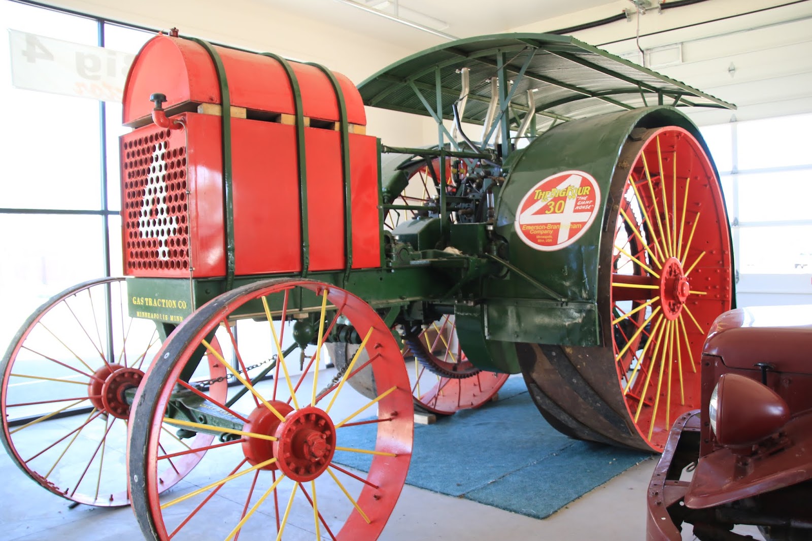
Since the slot canyon adventure was unavailable, we took a ride 15 miles north to the next town of Monticello, Utah.  It’s an agricultural town with vast rolling farm lands that were reclaimed from the original pinion / sage prairie.  There wasn’t much open on a Sunday or much of interest to see until Twinkles said, “Did you see that huge tractor back there” ?  A quick U-turn was made after which I saw this amazing old tractor inside a building next to the visitors center.  The visitor center amazingly was open and it also contained a small folksy local museum (I love those kind) and the woman at the desk said the door to the tractor building should be open.  This Tractor turned out to be an amazing story and made my day.  It is a monstrous 1913 Emerson - Brantington Big Four Tractor, weighing 18,000 lbs.  It was purchased new for $ 4,000 (delivered) by the San Juan Arid Farm Company, shipped by rail to Delores, Colorado and then driven to Monticello, Utah.  It was used successfully for many years to plow 8,000 acres of unbroken prairie land to plant wheat and oats as a preparatory crop for Alfalfa. It then became a roadside attraction for a number of years until a dedicated Monticello resident bought it and turned it into a restoration project.  It seems that the community came together to help with fund raising and storage space.  It has been completely restored, is in running condition and is operated in the Monticello Forth of July parade.  There are only two other such Tractors known to have survived, one in Canada and another in the US in badly deteriorated condition.


The Big 4 Tractor with those great spoke wheels


Front view 


The guide wheel shown in this ad was found half buried
in a field during restoration by a man who used to deliver gas
to the Tractor when in operation


A mural in Monticello


1832 history of the US was brief ?


Jens Nielson was a Mormon bishop and quite a man


A former championship rodeo saddle, Monticello is still a cowboy town


Wonder Flour made in Monticello


Quite a story about making quilts from Bull Durham sacks


Afterwards we rode another 12 miles to see Church Rock, a prominent rock formation jutting up out of the mostly flat prairie.  The story of Church Rock is rather weird and interesting.

https://en.wikipedia.org/wiki/Church_Rock_(Utah)


I like the soft light in this photo


Church Rock is on private ranch property, it appears that the cows like to sit
in the shadow of the rock


We also took a ride on a dirt county road south of Blanding heading for the Three Kiva Pueblo but after about 10 miles, although a nice ride, but with another 20 miles to go we decided it wasn’t worthwhile.  The ride went through some beautiful country and along the way we happened upon two other Anasazi ruins.  I always thought these ruins were sparse, but am now finding that they are in many of the canyons here that have a reliable water source.  It is a big issue regardless if the ruins are on private or government land, protected or not, as the worth of the pots and artifacts is lucrative for pot hunters to vandalize these sites.  Most of the easy to get to ruins were picked clean years ago.


It's a scenic drive far into the back country


A sheep ranch along the way, they have eaten all vegetation


We spotted this small rock dwelling high up in an alcove in
the canyon wall


Next the road was this larger dwelling with part of a wall still remaining.  Note the
evidence of smoke on the ceiling


Afterwards we continued on to the town of Bluff, Utah which was settled by the Mormon settlers who arrived by the Hole-In-The Rock Road from Escalante, Utah.  We visited Fort Bluff which was their original settlement.  They have done an amazing job of reconstructing the settlers cabins that are decorated inside by actual family decedents.  Each cabin has photographs and information on the settlers, most impressive.  One of the original cabins remains that has been left in it’s original deteriorated condition, it had a ghostly feel to it.

  https://en.wikipedia.org/wiki/Bluff,_Utah


This rock formation is the Navajo Twins, the store and restaurant have somewhat ruined
the scenic beauty of it all


Jens Nielson, (again) Mormon Bishop, with photos of his three wives


The Walter Lyman cabin nicely decorated by decendants
 

Joseph and Harriet Barton and family, you will see the
remains of their cabin below


Sarah Perkins with her 9 daughters and only son in
the background.  That boy must have had it rough ?


The original unrestored Barton cabin


How many people have walked over that door threshold
and the stories it could tell ?


I thought this to be a very cozy bedroom


A most scenic burial ground


Old chevy truck in front of the Navajo Twins rocks


A classic 50's Buick in front of the Cow Canyon Trading Post


About 2 miles away from the campground is the Recapture Reservoir which is formed by a dam on the Recapture Creek.  As I was doing research on this area I found that this area has come under considerable controversy since the BLM banned ATV’s from going into the Recapture Creek Canyon area.  It seems the ATV’ers were making a mess, rampaging all over and making new trails, spewing trash around, so the BLM shut the trails down.  In these parts, the ATV legions are like the NRA, they have clout and a local County Commissioner got involved and organized a protest ride inviting the anti government faction in to participate.  So all these so called “Patriots”, a very overused word, came in and tore around making more of a mess, he was arrested for instigating this and I suppose has now achieved local hero status.

I don’t know how these sort of issues will ever be resolved as you have two or three totally dedicated and opposing sides.  You have the Archeologists who want these ancestral Indian sites strictly preserved (not touched in any way) and the American Indians who consider these sites sacred.  You then have the ATV’ers and to a lessor degree even the bikers and hikers who consider this their land and feel strongly that they should have free reign to use it.  As these Ancestral Pueblo ruins are all over and the sites can contain valuable articles worth considerable money, people are naturally attracted to the hunt for them, as they have done for the past century, but it’s now against the law.  This same fundamental issue is at the heart of the controversy about the Bears Ears National Monument. 

Utah is one of the most beautiful states in the US and at the same time one that doesn't seem to quite belong.

The next stop is Mesa Verde National Park, Colorado,
Twinkles and Slick

Tuesday, May 22, 2018

Blanding, Utah, Natural Bridges and Anasazi ruins

May 10 - 12, 2018:

Our ride today from our campsite on route 24 and through Capital Reef National Park was one amazing view after another.  At the rustic town of Harksville we head south on an equally scenic wonder, route 95.  The claim that route 12 is the second most beautiful road in the world may be incorrect, it could just as easily be route 95.  It was a windy day with many steep up and down hills and plenty of distractions to make the RV wobble a few times.  All the way along route 95, I was thinking;  forget about all those crowded, bucket list places loaded with tourists rushing around such as Zion - Bryce - Capital Reef - Canyonlands and Arches.  That amazing terrain is all here in a less developed, more wilderness state with lots of free BLM camping available.


The road ahead


The terrain was wild ahead


Looking down at Glen Canyon from the highway


Interesting downhill view and ride


I arrive at our destination, the Blanding RV Park in Blanding, Utah about 2 PM and into a full hookup campsite as we need to get cleaned up, to restock our cupboards, get a phone signal and use WiFi.  After getting settled, I go to the visitors center for local information and find a small museum there.  It has some interesting exhibits especially on the first settlers, Albert R and Mary Ellen Lyman, who came from Bluff in 1905.  Albert R Lyman became a self taught scholar, a passionate history enthusiast, a newspaper editor and a prolific writer.   There was also interesting stories on a couple notable Indian leaders.


Albert and Mary were a good looking young couple


Albert went on to write several historical books


He did his writing in a stone cabin he called the
Swallows Nest


I’ve been in the mood for a good diner breakfast spot for a while now and haven’t found one until now.  I read the reviews for Yak’s Center Street Cafe and liked what I heard.  It looked somewhat dumpy from the outside, but that’s OK, it could give it more character.  I’m just looking for the  basic eggs, bacon, home fries and toast breakfast and that’s what I got, the service was quick, the decor inside nostalgic and the food just OK.  You’ve got a Navajo group at one table speaking a mix of Navajo and English, a local biker couple at another table and another table of tourists, I fit somewhere in between this mix.


Yak's Cafe
   
Afterwards we take off for an adventure, back northbound on route 95 to a turn-off for the Butler Wash where they is a short trail to a viewpoint for Anasazi Ruins.  This area of Utah is loaded with Anasazi ruins in these remote canyons.


Butler Wash


A closer view


The cliff dwellings were in a green protected area


View from the trail with pockets of water in the rocks


A long slender snake was encountered


Next stop was another pull-off for the Mule Canyon Anasazi Ruins, where there is a trail that takes you into a canyon where they are located.  We looked for a trail sign or information, found nothing, rode around a while and then left.  A short distance away is a road side Anasazi ruin site with interpretive panels.  Later, I found out we were right there, but time was short and we were focused on going to the Natural Bridges.


A reconstructed pueblo and Kiva near the road 


It was an extremely windy day with 25-35 MPH winds and gusts to 50 MPH and so many, too many, people told me to watch my hat.  My hat chin strap that Twinkles says looks dorky, (actually it does), saves the hat several times.   

The Natural Bridges National Monument was the first National Monument established in Utah by none other than Theodore Roosevelt in 1908.  There is a visitors center and a loop drive with several canyon view points and trailheads down to the three Natural Bridges.  These are huge bridges, some of the largest in the country and are located down in the canyon from 180 to 500 feet below the canyon rim.  I went part way down the trail to the largest bridge, the Sipapu, which is the second largest Natural Bridge in the country.  I then went all the way down 400 feet to the Kachina Natural Bridge, quite a steep hike, but the view under the Bridge was totally worth it.  Twinkles and I then did the last Bridge, the Owachomo, which was about 180 feet down.  It is the most eroded Bridge, but is still a massive size.  There is also the 700 year old Horsecollar Anasazi ruins in a remarkable state of preservation at the canyon bottom.  The best way to see it all is to go down at one of the Natural Bridge trails and then take the loop trail to the other Bridges and then back up to the rim.

https://en.wikipedia.org/wiki/Natural_Bridges_National_Monument


A view looking far down at the  Sipapu Bridge


Looking down at the Horse collar ruins, there are two people there


Looking into the canyon, note the smooth eroded shapes


Very nice blooming cactus


On the exposed trail down to the Kachina Bridge in the gusty wind


Water pond down at the sandy bottom under the bridge


The Kachina Bridge is huge, the people walking add some perspective


Looking up at the massive thickness of the bridge


A good example of the sand bedding patterns in the sandstone rock
 

The Owachoma Bridge is a very long span but looks to be getting thin on top


The ride back to Blanding takes you up this steep climb where you
make a shark hairpin turn just before the last rock


Needing a break from hiking we went to the highly regarded Edge of the Cedars State Park Museum in Blanding which is at the site of an Ancestral Puebloan ruin inhabited from about 825 to 1225 AD.  This museum was excellent, loaded with artifacts and information, a huge collection of bowls and baskets and information about the ruins.  There is one room detailing all the Archaeology done at the ruins with artifacts labelled and displayed from each room.
There was a special exhibit on a most interesting woman, Louisa Wade Wetheril, known to the Navajos as Slim Woman.  She lived in Oljato, (Moonlight Water) for the rest of her life with the Navajos, spoke the language  and was so highly regarded that they adopted her into the tribe.

https://www.azwhf.org/inductions/inducted-women/louise-wade-wetherill-1877-1945/

https://stateparks.utah.gov/parks/edge-of-the-cedars/


Louisa gained much fame


She documented native medicinal plants


She recorded Navajo stories and language


A grouping of artistic pots from the region


The really good stuff is locked away in this room


The Edge of the Cedars ruins in front of todays suburban development


Blanding, Utah is a very strange town, it has the Mormon culture and influence coupled with a large Native American population.  There isn’t much to do in Blanding, there are very few restaurants, only the most basic shopping, no night life and simply not much to do.  There is a small movie theater and what appears to be the hot spot, the Bowling Center with convenience store and an A & W Root Beer restaurant.  We went inside for lunch at the A & W Root Beer and were surprised how nice and clean the seating and bowling areas were.  It was somewhat of a culture shock, like something from 1960 and to me the Root Beer never tasted better.  The Blanding RV Park campground is behind the 7-11 convenience store which seems to be another hot spot, always busy with the locals, a mix of Indian and Anglo, mostly overweight and rough looking, buying junk food and enormous “Big Gulp” drinks.


The San Jose Theater in Blanding


A couple of coffee shops in Blanding, strange for a Mormon town


The A & W Restaurant with a classic mural


The Bowling Alley


https://en.wikipedia.org/wiki/Blanding,_Utah         


Our next stop is a few miles away at the nearby Devils Canyon campground for a couple of days,

Twinkles and Slick