Thursday, November 28, 2013

Cottonwood, Sedona and Jerome


November 21-26, 2013:

A big travel day for us, 200 miles, taking Rt 89T (Indian Rt 20) through miles and miles of Navajo land to Rt 89 south to Flagstaff, then Rt 40 west to Rt 17 south to Rt 260 to Rt 89A into Cottonwood, Arizona.  We arrived at the Dead Horse Ranch State Park just on the outskirts of Cottonwood about 2 PM.  It is a easy large pull through campsite with electric and water, dump station nearby and bathroom/ shower within walking distance.  It was very cloudy all day, with on and off periods of rain and quite cold, 39 degrees just north of Flagstaff, down in the Verde Valley at Cottonwood it is a mild 50 degrees.  Snow is forecast for Flagstaff on Friday, heavy snow up in the San Francisco Peaks, we seem to have just squeaked through.  The plan is for 6 days here, lots to do and then to Phoenix for Thanksgiving with the family, then on to our winter destination in Tucson.

Threatening view along Route 260

Frosty morning view from the campsite

It seems we have arrived in time for the monsoon rains, it rained steadily all night and is forecast to continue all weekend with possible localized flooding.  Fortunately we seem to uphill from the Verde River.  

We drove through downtown Cottonwood, which has a section called "Old Town" with many restaurants, antique shops, a couple of pubs and an assortment of tourist trap shops.  Next, we drove to Sedona to look around but the Red Rocks were mostly obscured by the dense rain and clouds.  We stopped at the local chamber of Commerce to get some ideas of things to do.  They recommended visiting the shops at Tlaquepaque, which was a very upscale shopping plaza full of galleries, cafes, a brew pub and various other artistic and specialty shops.  At almost every shop we entered, the shopkeeper would ask where we were visiting from and we would go through the whole living full time in a RV spiel.  This happens a lot as we travel and it usually starts a long conversation, almost always good, but after three or four times in a row, it gets old.  So when asked, we look at each other and laugh and take turns answering.  Sometimes you just want to give a town name and be done with it. 

Cottonwood mural

Another mural

Larry's Antique Store is great

Tons of old stuff for sale

Very cloudy Bell Mountain outside Sedona


On Saturday, it was another cloudy, rainy day so we set off to the town of Jerome, 8 miles away, to go to the Jerome Historic State Park.  It is another excellent museum on the rich Copper mining history of Jerome.  The town itself is situated on a steep hillside, a mile high, with mine tunnels all over and a fault running through the center of it all.  They have had problems with landslides in the past and with buildings sliding downhill, the most notable being the town jail which has slid a couple hundred feet down the hillside.  It was another wild colorful boom town in it's day that almost became a ghost town after the mines closed.  In the 1960's an influx of counterculture types came in and started artistic shops and such which resulted in the tourism industry of today. This is the third time I have been to Jerome and it is a favorite Arizona town of mine, many similarities to Bisbee, AZ.  We walked past the "Spirit Room Saloon" in mid afternoon and saw that a band, "Cadillac Angels" was starting at 2 PM. It is a very cool old western Saloon, the place was packed, the band was good and it big fun. Leaving Jerome, the clouds had lifted somewhat over Sedona, visible at the horizon and the sun was illuminating the red rock mountain formations.  It was a stunning view and some one must have gotten an incredible photo. 

View of Jerome from the museum

Model of the Copper Mine and underground shafts


Lots of Railroad history in Jerome

Largest Mine Headframe still standing
in Arizona, built in 1918

The Hotel Connor in Jerome

Jerome, Too strong to Die
  

Sunday, the rain is ending, but it is still very cloudy.  We go in the afternoon to Montezuma Castle National Monument where the Sinagua culture lived in a five story 20 room cliff dwelling, 100 feet above the valley floor from around 1100 AD to 1300 AD.  Nearby is another badly deteriorated dwelling, Castle A, which originally was a five story, 40 room dwelling.  The Sinagua people were a quite advanced culture and farmed the valley floor.  They built irrigation canals from the year around flowing river.  These people were in large numbers and had pueblo type dwellings all over the area.  We then went a few miles away to the Montezuma Well.  This is a huge sinkhole that is continuously kept filled by underground water that surges up from below.  The Sinkhole has an outlet that naturally regulates the level of the lake water with the discharge going out into a creek.  There are ancient cliff dwellings around the perimeter of the sink hole.  In addition, there are five unusual animal species that live in this lake that exist nowhere else in the world, quite amazing ! 


Montezuma Castle view


Inside the Cowboy Corner Store

Lots of old Saddles for sale

Montezuma Well

Cliff dwelling at the Well

Cliff dwelling ruins at lower part of Well

Indian dwelling ruins at top of the Well

Monday, freezing in the morning, but lots of sun and blue skies, so off we went for some hiking in the Sedona area.  Our objective was the Bell Tower Rock area but when we got there all parking spots were taken.  It seems there are still lots of tourists, more than we expected in late November, maybe due to the Thanksgiving holiday ?  Anyhow, we then went to the next turnoff parking area, no spaces there either.  The third pull off area was the charm, we parked and went off onto the "Little Horse" Trail not knowing where it went or how long it was.  A passing couple told us it was great and so we stuck to it and it turned out to be fantastic.  It ended up being about 2 1/2 miles long, very scenic, culminating on top of a large rock Dome with a great 360 degree view of the surrounding terrain.  We passed very few people on the trail, however when we arrived at the end there were about 30 people standing on top of the Dome.  We wondered how they got there until we saw the "Pink Jeep Tour" vehicles parked there which had carried all the people to the top using a dirt road on the back side of the mountain. Afterwards we stopped in "Up Town Sedona" to window shop, we found everything there to be so touristy, not much of a real town feel to it.  There are two Sedona now, the "Up Town Sedona" and the "West Sedona".  It will always be a beautiful place, but so much traffic, so much development, it's sort of ruined.  This is what happens when paradise is left in the hands of Developers, Bankers and Realtors.

View from the Little Horse Trail

Yucca Plant

View of the Dome near end of the trail

Pink Jeep tour stop
View along the Little Horse Trail


Tuesday freezing again, then another short, but great hike on the Chimney Rock Trail which goes 360 degrees around the very scenic Chimney Rock.  It really does resemble a chimney, I often take exception to these named rocks, especially the animal ones.  The recent rain really soaked into the red rock soil and everything green appears to have burst back to life.  We then went back to Old Town Cottonwood to the "Red Rooster Cafe" for lunch, very good. 

Chimney Rock view

Chimney Rock up close

Twinkles posing along trail


Tuesday night I ventured back to Jerome, up the long winding dark hill to the "Spirit Room Saloon" for acoustic Tuesday.  It really wasn't genuine Acoustic but close enough for me.  It was a duo from Phoenix called Mr. Mudd and Mr. Gold (taken from a Townes van Zandt song) who were very interesting, entertaining and played a mix of bluegrass, blues, country and folk utilizing guitar and banjo.  It was a small but fun crowd for a Tuesday night. The view from Jerome at night is very special as the town sits up high on a hill side overlooking the Verde Valley which is filled with lights.

Mural behind bar in the Spirit Room

Interesting picture poem in the Spirit Room

Mr. Mudd and Mr. Gold

Next stop is the Destiny RV Park in Goodyear, Arizona in time for Thanksgiving with my mother and sister's family in Avondale, Arizona.


More to follow,
Twinkles & Slick

Wednesday, November 20, 2013

Page Arizona and the Glen Canyon


November 18 - 20, 2013:

We left Zion heading for Page, Arizona at 9 AM.  As we couldn't go through the Zion Mt-Carmel tunnel, we had to take the long route to Page.  That would be route 9 west to Hurricane UT, then route 59 south to Fredonia AZ, then Route Alt 89 north to Kanab UT and finally route 89 east to Page AZ.  It was all good RV road, light traffic and very scenic.  We arrived in Page about 1 PM and set up at the Page-Lake Powell Campground which is a full hookup site.  This is to be a short stay, 3 nights before heading towards the Sedona, Arizona area.

View of the Campground from rocks above

We headed to the Horseshoe Bend overlook where the Colorado River makes a very scenic tight 180 degree turn.  It seemed like a tour bus arrived just after us, hordes of foreign speaking tourists converged on the overlook.  We also stopped at a Glen Canyon Dam overlook nearby that was pretty incredible.
View of Glen Canyon from overlook

Horseshoe Bend 

On Tuesday, we visited the excellent John Wesley Powell museum and the Glen Canyon Dam.  By chance we have been reading a book, "Down the Great Unknown", on Powell's historic journey in 1869 through the Grand Canyon.  The museum has really well done exhibits on John Wesley Powell and his exploration of the Colorado River, history of the native people, geology of the area, other notable early river boat guides, the building of the town of Page and the Powell Dam.  After filling our heads to bursting with all this information, we went to the actual Dam.  It is a mind boggling sight !  The Visitors center at the Dam also has excellent exhibits on the need for the Dam, the building of the Dam and the operation of the Dam for flood control, water storage and electricity.  We also took a fascinating 45 minute tour of the Dam along the top of the Dam and then down to the generator area.  The Glen Canyon Dam was built between 1956 and 1966 and is the second highest Dam in the country and the vehicle bridge over the Canyon is the second highest Steel Arch Bridge in the world.

Museum model of the Powell party on the river

Boat of noted early river guide, Norman Nevills

Manifest Destiny guiding the early settlers west

View of the Glen Canyon Dam

View of the Glen Canyon Bridge

The Generator Room in the process of being upgraded

The town of Page and the Glen Canyon Dam are making me feel like an old timer !  When I was born this was a wild river Canyon and a mesa, miles from civilization, there was no town of Page, no Bridge or Dam.  It always amazes me how recent our history in the west really is, like yesterday in geological time and how man has so altered the landscape in the past 300 years.  

Wednesday we took a Navajo Indian tour of the Upper Antelope Canyon, it was a cloudy day which they said would improve the lighting inside the narrow Canyon.  It was as spectacular as advertised, however it did get a little congested with everyone in each others way, trying to get that great photo.  The tour guide did a good job of pointing out the best photo positions and keeping everyone moving.  They have had 14 flash floods in the Canyon this year which was raised the level of the sand floor many feet.  During a flash flood the water can rise to  near the top of the rocks, it's an amazing Canyon.


Amazing shapes, colors and contours !

Another view

And another

And another

Twinkles in the light

Twinkles iphoto might be the best 


This Page-Lake Powell Campground has turned out to be a winner, great WiFi, cable TV, heated indoor swimming Pool, nice shower room, exercise room, in a scenic setting on the edge of Page, AZ within a mile of all the services, stores and restaurants needed.

Solidified layers of drifting sand behind campground

Nice sunset over Campground


The Red Rock Tour moves on Thursday, November 21st with a trip to Cottonwood, Arizona, near Sedona, where we have reservations at the Dead Horse Ranch State Park.  There is rain in the forecast just to make the trip more interesting. 

More to follow,
Twinkles & Slick

Monday, November 18, 2013

Zion National Park


November 11 - 17, 2013:

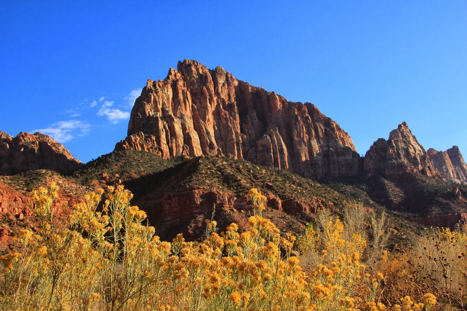
We get off to an early start from the Valley of Fire campground at 8:30 AM for the trip to Zion National Park in Springdale, Utah.  As we are driving through Valley of Fire, we come around a curve and right next to the roadway are a herd of Big Horn Sheep.  That was quite a thrilling way to start our trip and we saw it as a good omen.  We then got to the town of Overton and squeaked through Main Street just before they were going to close it for their Veterans Day Parade. The ride on Route 15 north took us from Nevada into Arizona through the incredible Virgin River Canyon and then into Utah.  The Virgin River Canyon was a big surprise, enormous mountain peaks all around a downward spiraling roadway.  We went through the impressive upscale border town of Mesquite, Arizona then the equally prosperous looking St. George, Utah.  We exited onto route 15 east to the town of Springdale, Utah at the southern entrance to Zion National Park.  We checked into the Watchman Campground at Zion, which is inside the Park, right at the Park entrance.  Our reserved campsite was an awkward back-in site, but I got in in better than expected.  Once in, it was beautiful, we have a picture postcard view of The Watchman Mountain from our dining table window.   It is an electric only campsite, but water is easily available, there is a dump station and all for $9 a day.  We went out for dinner in Springdale, which is a small tourist town with lots of restaurants, hotels and shops.  We had seen good reviews for "Cafe Oscar" and we were not disappointed, huge portions and really good ! 

View from the RV window

Watchman Campground entrance

The Watchman mountain

It is another dark sky place here, I went out the door to take a look and was startled by a deer less than 10 feet away.  Latter in bed, we heard some scratching noises up on the roof, initially we thought there might be some wild creature up on top of the RV as we have a tree overhead.  It turned out to be a low hanging tree branch rubbing against the roof.  Will the park service be upset if I trim the tree branch ?  

After last nights huge meal, hiking is mandatory on Tuesday, so we are off to the Emerald Pools trailhead.  It is about a 3 mile hike, much uphill with many steps/rocks, but super scenic views in every direction.  The trail takes you to the lower, middle and upper pools which are fed by small streams which drop over the cliffs as waterfalls.  We then visited the Zion Human History Museum and watched the inspirational movie.  There is so so much to see in this area, could spend a lot more time, definitely a return trip is needed.  Finally, the highpoint of the day, a much needed visit to the Laundromat !  

The Zion Lodge, really nice !

This is what you see across from the Lodge


Waterfall dropping over ledge above
on the Emerald Pools Trail

Amazing view on the trail

Towering Sandstone rock face

View from above of the stream dropping over edge

Great cloud formations

Wednesday is a solo (separate ways) day for us with Twinkles wanting a somewhat relaxing day and an easy river hike.  She wants me to go off and do a more challenging hike, claims she is holding me back, or has she taken out a large insurance policy on me ?  Anyhow, I go off and start on the short 1/2 mile Weeping Rock Trail which is pretty wimpy but I wanted to see the water that comes out of the rocks that has been dated at 1,2000 years old.  That's how long it takes for the water to percolate down through the sandstone from the mountain top to the bottom. 
I then did the Hidden Canyon Trail with a little apprehension about the heights and the warning signs.  The trail was all rock and very steep for a mile with short portions following a cliff ledge on which they had chains for handholds.  Once at the top you enter a narrow Canyon with incredibly huge vertical rock faces.  The Sandstone is eroded in places like a work of art.  It is difficult to stay focused on where you are planting your feet when you are constantly looking up, mesmerized by the beauty around you.   


One of the most scenic parking spaces I ever had

View from the Hidden Canyon Trail

The top of the trail ends at a hanging Canyon
which at times becomes a raging river and waterfall

I venture into the narrow Canyon

Incredible vertical wall of rock

Really massive wall of rock !


A stone arch where the canyon trail ends

The erosion and colors were spectacular

Artistic shapes in the rock from weathering

The trail had some areas to tread carefully


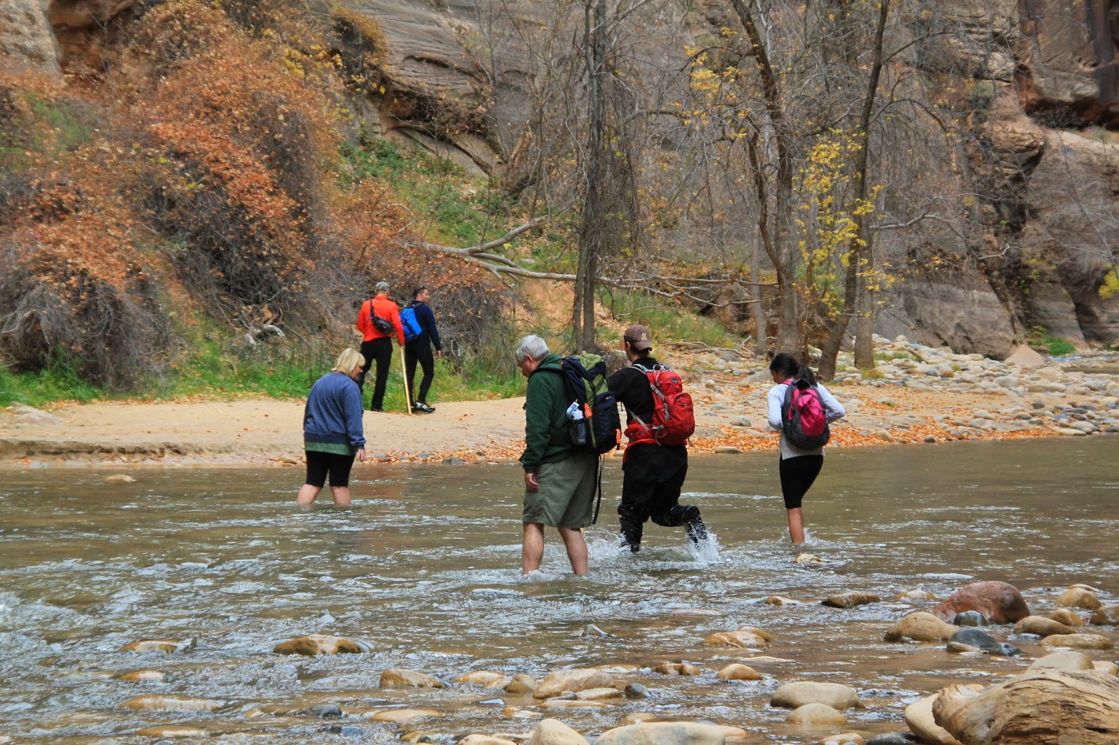
I then went to the Temple of Sinawava parking area to hike the easy Riverside Walk Trail.  This is a trail that goes increasingly deeper into the Canyon until you need to walk in the river to proceed further. I stopped at that point as I had intention of walking in the icy cold water.  It is possible to rent waterproof gear for this purpose, but it is definitely more of a summer time thing.  The trail known as the "Narrows" becomes a slot canyon and is a huge Zion favorite attraction. 


Entrance to the Riverside Walk Trail

The Virgin River from the Riverside walk trail 


View from the River

People going into the river


The Ancestral Puebloans lived in the Zion area for many thousands of years, they eventually disappeared and were replaced by the Paiute Indians around 800 years ago.  In the 1860's Mormon's settled in the area seeking a haven from religious persecution.  That was the beginning of the end for the Paiute Indians. The Mormon's called the Place "Zion" representative of a place of safety and refuge for them.  The Mormons also gave most of the prominent mountain peaks biblical related names such as; East Temple, West Temple, Temple of Sinawava, Angels Landing, The great white Throne, the Pulpit, Court of the Patriarchs.  

In between all this beauty, some RV maintenance was required, I  repaired another failed window shade and removed a trailer tire that was not looking healthy.  After removing it and looking closely, I was real glad to get it off, it was about ready to self destruct.  I was initially going to swap the spare tire onto this wheel, use the old tire as the spare, (being cheap).  The tire shop guy downtown took one look at it and said he wouldn't even use it as a spare.  He had a pair of new better quality tires in stock so I ended up buying two of them for some peace of mind. I have now replaced all four tires on the RV.

In contrast to neighboring Nevada where about everything is legal, Utah has very conservative Mormon influenced liquor laws.  There does not seem to be an actual bar in the town of Springdale.  In restaurants, you can't just have a drink, you must order food first.  Also all alcohol has to be metered out, no happy hour drink specials, very restrictive laws.  Lots of confusing liquor licenses for special occasions, clubs, etc.

On the weekend, auto traffic is not allowed in Zion Canyon, a shuttle bus service is run to the various shuttle bus stops.  They do this every day during the peak season time.  We are looking forward to using the shuttle as it is not always easy parking the dually at the smaller parking areas.

A ride on Sunday to the east side of Zion Park on the Zion-Mount Carmel Highway through the historic tunnel.  A special permit was needed to drive the dually through the tunnel, they shut it down to one way and then allow you drive down the center.  The 1.1 mile tunnel, completed in 1930, was at that time the longest tunnel in the country. It's hard to believe, but the east side might even be more scenic than the main Zion Canyon area.  We saw many Big Horn Sheep along the road and in the road.  

Zion Mt-Carmel Highway view

Could be a GMC Truck advertisement ?

Highway scenic view

Incredible shapes and contours

Another Highway scenic view

Weird Sandstone shapes due to erosion

Large Lava rocks in foreground make for interesting shot


We continued through the East Zion Park gate to the town of Mt. Carmel Junction which had an old stone Mormon Church and historical markers for an early Mormon settler, Isaac Behunin. 


Mt. Carmel also has the Thunderbird Restaurant, hotel and golf course, home of the HO-MADE PIES with a scantily clad woman on the sign.  We had to stop for lunch, the food was good and the HO-MADE Bread was really great.  It's a restaurant started in the 1931 with an interesting history and still family owned and operated.  When they painted the sign, there wasn't room for Home Made, so it was abbreviated to HO-MADE and in the 1930's HO didn't mean what it does today.  They have kept the signage and have even developed a whole line of merchandise to sell with the HO-MADE theme.


The Thunderbird Restaurant sign


We took the short but very interesting Canyon Overlook Trail near the tunnel where we saw more sheep up on a mountain side.


This guy was crossing the highway and stopping traffic

Twinkles crossing bridge on Canyon Overlook Trail

Sheep high above us on the Trail


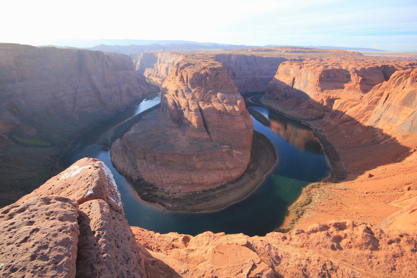
Next stop on the Red Rock Tour is Page, Arizona, gateway to Glen Canyon Dam, Horseshoe Bend, Antelope Canyon and much more.

Keep on rocking in the Free World,
Twinkles & Slick