Sunday, April 29, 2018

Cathedral Gorge State Park


April 23 - 25, 2018:

We had a beautiful ride today on routes 15, 168 and 93.  It was especially scenic on route 168 and 93.  We actually had route 168 all to ourselves, I don’t recall passing another vehicle for thirty some miles.  Route 93 passed through the lush green, fertile Pahranagat valley and lakes surrounded by mountain ranges on both sides.  It was a ribbon of green sandwiched by arid desert terrain.  There were lakes, swampy areas, a large wildlife preserve, several farm and ranch lands and the quaint towns of Ash Springs and Alamo.  We then climbed uphill through a forest of Joshua Trees and then over the Oak Springs Summit.  I even passed what appeared to be three wild horses on the road way.


The green Pahranagat Valley


Wild Horses on the road
  

Twinkles drove the Jeep today and arrived at Cathedral Gorge State Park ahead of me to claim a campsite.  It is a first come-first served  campground with nice roomy sites with canopy covered picnic tables, a fire pit, a shower house and optional electric.  This is unusual in that all sites have a power box, if you elect to use it you pay an extra $10 a day, if not you pay the standard $15 a day.


The campsite

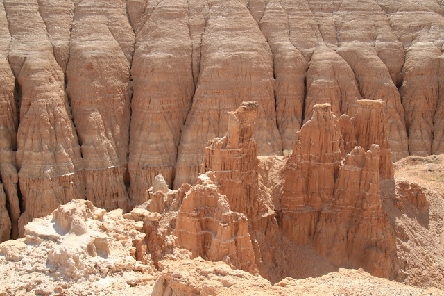
Cathedral Gorge State Park is amazing, the rock shapes and spires truly look like cathedrals and the mudstone slot canyons are like something out of this world.  It seems you can wander into any of these slot canyons, no warning signs and none are closed off. Most are short, but we were in a couple that went quite far with branches and caves.  It might not be a good place for you if you suffer from claustrophobia or if you worry about the tons of rock above you that potentially could fall.  Erosion has created a artistic masterpiece here !


It's an amazing view !


I think of melted candles as I look at how
these old lake sediment deposits have eroded
 

There are slot canyons and caves in these formations,
note the tumbleweeds piled up in front


You are free to wander in and explore,
I wonder how many people have gotten lost ?


Looking straight up


This particular canyon had a 2 X 4 propped
across, that made me a little nervous


A trail not to be missed is the Miller point Trail which takes you into the Canyonand then up a staircase to a series of metal stairways to the Miller Point observation deck and picnic area.


We are making our way up a series of steps to the observation platform


Looking off to the side, it's hard to stay on the trail


In every direction, amazing !


Coming back down with a panoramic view


Heading downhill into the canyon


This stone spire at the trailhead really stands out near a picnic area built by the CCC


There was once a small town of Bullionville where a smelter was located next to the State Park.  A small graveyard is about all that remains today, there is a short trail to it, a few gravestones are there, but most graves are unmarked.


This is one of the few markers, but it is touching to read as
each side notes the death of a young family member


A few other noteworthy trail photos and views at the State Park.


Looking down into the valley


A very pointed peak


This spire is almost worn away


I did a solo adventure to the nearby interesting towns of Panaca, Pioche and Caliente. 

Panaca is adjacent to the State Park and is a small farming community  with green irrigated fields and range land.  It is the oldest town in southern Nevada settled in 1864 by Mormon pioneers.  It is also the only dry community in Nevada.  There isn’t much to see in downtown of interest except for a few old stone houses and an impressive Lincoln County school complex.

https://en.wikipedia.org/wiki/Panaca,_Nevada


The founders, devout Mormons


I thought the Spud Shop was interesting, I was wondering
what Spudnuts were ?


Pioche became the largest mining town in southeastern Nevada with 10,000 people in 1871.  It all started in 1864 when William Hamblin, a Latter Day Saint Missionary, was led to Silver deposits by a native Paiute Indian.  In 1868 San Francisco financier Francois Pioche purchased the claims, built a smelter and started the Meadow Valley Mining Company.  Due to its remote location, it was lawless and one of the toughest towns in the west.  Hired gunmen were hired at a rate of 20 per day during the boom times to fight mining claim encroachments.  This town has lots of potential, but they are not doing much to attract anyone.  I went to the Pioche Museum which had some great stuff on display.


This was part of a cable car that moved ore down to the smelter


Almost across the street was this open mine pit surrounded
by only a barbed wire fence


Old store on Main Street


The Overland Hotel appears to be doing well


The GEM Theater is for sale, needs a savior


As I took this photo a man came by and started a conversation.
He was 80 and told me he was married in this Lodge building.
It was built in 1873, one of the oldest in Nevada.


Interesting old photos and advertisements on this
store front


A line of organs from town that were saved, restored
and donated by a local man


The Court House

Old hotel next to the Court House, in rough condition


Caliente was founded as the Culverwell Ranch in 1901 and named for the hot springs found there.  In 1905 the Union Pacific Railroad was completed through Caliente which became a train yard creating much business and employment for the town.  It remains a vibrant rail line today, but these days there is no maintenance shop or yard.  It has a wonderful Spanish mission Train Depot, built in 1923,  with lots of potential, but it's in rough condition, needing paint and exterior work badly.  The "Boxcar Museum" is located adjacent to the Depot, but there isn't much on display.  Caliente look pretty poor and run down, I wasn't impressed.

https://en.wikipedia.org/wiki/Caliente,_Nevada


Boxcar Museum


Photos on display


Old town views


The Caliente Depot


The old downtown area, pretty run down looking these days


It looks pretty, but needs a lot of help


Next stop is Panguitch, Utah;
Twinkles and Slick

Saturday, April 28, 2018

Into the "Valley of Fire" we ride

April 19 - 22, 2018:

It’s a little over an hours ride to Valley of Fire State Park near Overton, Nevada.  We had been here before ( November 2013), but didn’t recall much about it, but as we got closer it started to come back to us.  We did remember it being a beautiful place and that’s why we decided to return.  

As we pull up to the entrance station we see the dreaded “campground full” sign.  When we asked for an update, we are told the campground fills every day and we need to pay the daily entrance fee and then just ride around and hopefully find a recently vacated campsite. We know that drill and we are here at an opportune time, about 10:30 AM,  when many campers are hopefully leaving, but there seems to be a many others like us also looking for a campsite.  We weren’t too worried if we failed to find one here as we had passed a decent looking boondocking site a few miles before the Sate Park.  We unhooked the Jeep and rode around through the two campgrounds, the first one was a bust, but at the second one the first site we came to was open.  It’s a dry camping site, but a water spigot is close by, there is a dump station, we have full sun and it’s one of the most beautiful campgrounds ever.


Camping among the red rock splendor


If you walk about 40 feet behind the campsite you see this


Valley of Fire State Park could almost be a National Park, the vast red rock terrain here is truly amazing.  As usual we hit the visitors center first and the adjacent, short nature trail.  We then go to the “Seven Sisters” rock formations and the original CCC camp cabin area.

https://en.wikipedia.org/wiki/Valley_of_Fire_State_Park


View next to the visitor center


Balanced rock from the trail


One of the seven sisters actually looks like a head


The CCC built much of the State Park and these were
a few of the cabins constructed during that time


A sandy and flowery area below the cabins


Day # 2 took us to the “Mouses Tank Trail”, the “Rainbow Vista Trail” and finally to the “Fire Wave Trail”.  These trails were all short but with great terrain and views.


Everywhere you look along the Mouses Tank Trail you see petroglyphs.  Mouse was an Indian in hiding for a murder who hid in this canyon.  At trails end there is a natural rock
bowl (Tank) that collects rain water


It's hard to believe they have remained so clear 


The Rainbow Vista Trail


The Mojave Prickly Pear cactus were blooming


Eventually you go into a rocky canyon


A chaos of rock at Trails end


Twinkles on the Fire Wave Trail


The colors and wavy grain in the rocks was spectacular
  

I felt I could almost reach up and touch that cloud


This young woman was putting on quite a show also


We had decided to ride to the nearest town of Overton, Nevada to visit the “Lost Cities Museum”.  I told Twinkles earlier that we had probably gone there on our previous visit and ironically the following morning she noticed she was drinking coffee out of a Lost Cities Coffee Mug.  

The ride to Overton, Nevada takes you past the entrance to Lake Meade Recreation Area and a short distance away a huge boondock camping site.  If you can’t get a campsite in the State Park, this is the place to go.

There isn’t much to do and see in Overton except for the Lost Cities Museum which was built in 1935 by the CCC as a depository for relics saved from the area to be flooded by Lake Meade with the completion of Boulder Dam, now Hoover Dam.  There is a long history of Ancestral Pueblo occupation in this area from about 300 BC to 1150 AD that extended approximately 30 miles along the Muddy River.  There are many theories as to why these people left, no one really knows for sure, but it is believed that they mostly assimilated into the Hopi Tribe.
The pueblo ruins were reported by local ranchers who wanted them protected in 1924 and they were promoted as “The Lost Cities” (pure genius) which made national headlines attracting much interest.  As a result, the CCC set up camp there in 1933 to do archaeological work and to build a museum.  It was critical to document and save as many of the artifacts as possible before the area was flooded.

http://nevadamagazine.com/home/archives/nevadas-lost-city/


The museum built by the CCC in 1935 is a treasure in itself


Museum interior

The museum is actually built on a pueblo site


Photo of a bowl found during in the dig and the same
bowl glued back together on display


Reconstructed pueblos behind the museum


On our final day we went for a hike on the “White Dome Trail” with vast expanses of colorful sandstone.


A very scenic drive through Valley of Fire


A Mojave Yucca view

Starting down the White Dome Trail


A mix of white and red rock shapes


Into a short slot canyon


The contrast of the red and white rock in stunning


Strange grain and texture in the rock


As the outer layer breaks away it is smooth underneath


This area of Nevada has a lot of this incredible landscape, much like Utah, but not as well known or crowded.

Our next stop is 150 or so miles north to Cathedral Canyon State Park;
Twinkles and Slick