March 29 - April 5, 2018:
We leave Desert Trails RV Park, it could be for the last time as residents, but we will definitely be back as visitors as we have developed many friends there. We are heading north on routes 10 and 17 through Phoenix to a boondocking site in the Coconino National Forest, east of Sedona, Arizona. We towed the Jeep from the campground to the “Rock Springs Event Parking” lot where we then unhooked for the brutal uphill climb to exit 179 for Sedona, Arizona. At the exit, instead of heading for Sedona we go in the opposite direction a few miles on forest road 618 and121 to the Coconino National Forest campground. The campground is in a beautiful setting on the edge of the Beaver Creek Canyon. On arrival, the choice campsites were filled so we grabbed the easiest remaining one. A few days later, when vacated, we moved into a choice campsite right against the canyon rim, it was a beauty ! This Canyon has a history of native habitation, (like the center of southwestern civilization) going back approximately 15,000 years and is in close proximity to Montezuma Well and Montezuma Castle National Monuments.
 |
| Moon rise over Coconino National Forest |
 |
Our roomy campsite in the red dirt
|
 |
| Behind our campsite was a scenic rock ledge to sit on |
We went exploring on day 1 and sort of stumbled onto the historic site of the “V Bar V Heritage Site” about 1 mile from the campground. This was formerly a cattle ranch, (after the Indians were removed), that used the 100 Brand and became known as the “100 Place”. It changed hands several times ultimately becoming the “V Bar V Cattle Company. All that remains today of the ranch is the beautiful stone chimney of the former ranch house amidst enormous old Cottonwood trees and remnants of fencing along Wet Beaver Creek. In 1994 the University of Arizona purchased the ranch which ultimately was traded to the Forest Serve for other property. As a result of being fairly remote and under private ownership for over 100 years the real treasure here was preserved, that being a rock wall covered with an amazing 1,032 individual ancient petroglyphs. The most amazing aspect of this wall is that it has features enabling it to be a solar wall or clock. Sun light projects onto portions of the wall to indicate the summer and winter solstice and times for painting crops. There also is evidence on the wall of both early Archaic hunter-gatherer civilization and of the later Sinagua Indian farming culture. A Forest Service volunteer at the wall gave an excellent talk describing the Indian culture and how the solar wall worked.
 |
The Sanagua were an advanced tribe who built terraces and canals
to direct water to the their crops and grew corn, beans, squash
and cotton. They made clothing with the cotton and beautiful pottery
|
 |
| A busy portion of the wall |
 |
The wavy line has dots that align with light to indicate planting times
|
 |
The docent described how a former bush pilot visitor
one day told him, "I know what that is", it's an area
river that I have seen while flying above. The docent
showed an arial map of the river that substantiates this.
|
 |
| Lots of petroglyphs, their meanings are not exactly known |
Later in the day we take a ride to Oak Canyon in Sedona stopping at the Forest Service Visitors Center and then a short scenic hike near Bell Mountain.
 |
Bell Mountain is a crowd favorite for a hike
|
 |
It's scenic in every direction here
|
 |
Courthouse Butte
|
 |
| Twinkles posing along the trail |
We soon found out that the Easter holiday weekend is not the ideal time to go into Sedona unless you like crowds and lines of stop and go traffic. We had decided to go for a hike on the Boynton Canyon Trail, but somehow Twinkles navigation went wrong and we ended up at the wrong trailhead. She does make a mistake once in a while ! So, rather than move to another congested trailhead, we stayed there and went on a hike to the “Devil’s Bridge”. It started as the "Chuckwagon Trail", a combination hiking and mountain biking trail, through a forest of manzanita, juniper and pinion with very few hikers or bikers. That all changed when we turned onto the “Devil’s Bridge Trail”, suddenly there were hordes of people and later at Devil’s Bridge it became apparent why. This is a very popular trail because;
1. To get to "Devils Bridge", there are three narrow, steep, rock stairways that are a little scary, something to get the adrenalin pumping.
2. There are plenty of places to take death defying photos along the cliff edges and while standing out on "Devils Bridge".
There was a long line of people waiting to walk out onto the bridge for a photo, the bridge is about 5-6 feet wide, but if somehow you trip, lose your balance or whatever, you my simply fall to your death. It’s strange to me that average people are perfectly willing to take this risk for the sake of a photo. Actually, it’s nothing new, people have been doing this since the camera was invented.
Afterwards we stopped at “Jim’s Trading Post”, it appeared to be junk shop from the outside, but the interior contained a treasure trove of fine antique treasures and curios.
Next stop was Montezuma’s Castle a few miles away, also on Beaver Creek, which is one of the most impressive and well preserved cliff dwelling sites in Arizona. It’s mind googling to think how these people built this mainly by hand with rudimentary tools. There was a large crowd of tourists at both sites appreciating these wonders, it’s nice to see !
 |
| Larry's antiques in Cottonwood |
 |
Cottonwood was another route 66 town
|
 |
| This old wall in Jerome always interests me ? |
 |
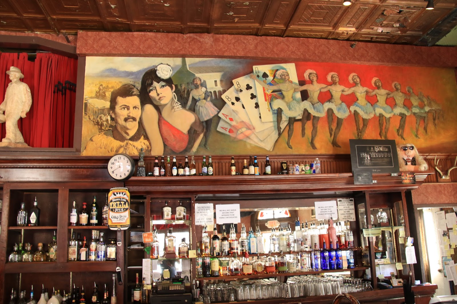
As does the bar in the Spirit Room
|
 |
One of these days I need to go down the road
to check out this mine
|
 |
Everything is either uphill or downhill on Jerome
|
We are becoming obsessed with the Indian heritage sites around this area, so our next stop is the Honanki Heritage Site accessed by a bumpy, dusty, dirt road on the west side of Sedona. The “Pink Jeep Tour Company” brings tourists in and conducts private tours of the ruins here and in return for this business they monitor the site. It’s still open to the general public, but you are not to join or interfere with the guided tours. It is the second largest cliff dwelling site behind Montezuma’s Castle and has 2,000 pictographs from every phase of occupation. Pictographs are painted objects or designs on the rocks rather than the more common gouged or pecked in Petroglyphs. It’s amazing that the pictographs have lasted this long, but they are usually in places very protected from the elements.
 |
A smooth section of the road to Honanki
|
 |
On the trail to the cliff dwellings
|
 |
They are in rough shape, but you would be too if abandoned
since about 1400
|
 |
The pictographs are still clear somehow, good pigments used,
they don't make paint this good anymore ? |
 |
| A section in better condition |
 |
| Another area with white coloring, different cultures used different colors |
Our next adventure was the Palatki Heritage Site a few miles away in a similar remote red rock canyon setting which was formerly a ranch started in the late 1800’s. There are cliff dwellings and a rock wall area covered with pictographs and a solar calendar feature. All of these sites were inhabited by various groups through the ages generally in this time frame;
Paleo period 11,000 - 9,000 BC (Clovis culture)
Archaic period 9,000 BC - 600 AD
Sinagua period 600 - 1300 AD
Yavapai & Apache 1300 - late 1800’s
Anglo settlers late 1800’s to present
We end up at another parking area trailhead further away and by chance go on the “Little Horse Trail” which turns into another beautiful hike, there really is no such thing as a bad trail in Sedona. We first passed a impressive towering rock formation and then came upon a rock formation that we remembered from a previous time here. It’s a huge dome shape sandstone rock called “Chicken Point” , no idea why ?, that is easy to climb up onto for great views and photos. The Jeep tour companies actually drive tourists using an adjacent road and are able to drive the Jeeps right up onto the rock formation.
 |
It just doesn't get much better than this
|
 |
That's the dome shaped rock on the right, you can see people on top
|
 |
| Another impressive angle |
 |
| There were several Jeeps on top |
 |
The native Americans were force marched hundreds of
miles from their homeland. This statue memorializes
the spirit of a man who carried his ill wife on his back all
the way in a basket
|
 |
Downtown Sedona is in a perfect setting but over populated
and developed |
 |
| The Indian is very sad |
After boondocking out in the red rock dust for a week, we are pretty gritty, in need of a shower, a laundry, fresh water, a dump station, a car wash. As a result, we have made a reservation at a full hook up RV Park for a few days to get cleaned up.
Our next stop will be Williams, Arizona and a train ride to the Grand Canyon;
Twinkles and Slick


No comments:
Post a Comment