Saturday, April 30, 2016

Death Valley California

April 21 - 25, 2016:


The trip started off calmly heading north on route 14 to route 178 and passing through the towns of Inyokern and Ridgecrest.  We then stopped at the Trona Pinnacles National Monument a few miles east of Ridgecrest.  We left the RV in the parking lot and took the Jeep 5 miles down a dirt road to the Pinnacles.  There are roads going off all over in this salt encrusted barren landscape.  The Pinnacles are impressive as you are able walk around and through them.  The Pinnacles were formed under water when this area was covered by a vast sea.  A sign indicated that many films have been shots there and as we were leaving a film crew came in with several large trucks.


They are much larger and impressive when walking amongst them


We next came upon the vast Searles dry lake and the town of Trona which was a company town that over the years has produced the minerals Trona and Potash.  It looks to be mostly poverty stricken by the ramshackle and abandoned houses along the route.  Outside of town was an interesting junk yard that I could roam around in for a while.  
Heading down route 178 I encountered something very special, a jet fighter aircraft flying towards me at low altitude through the valley parallel to the highway. That was a WOW moment !  I then stopped at a roadside marker for a nearby mining town called “Ballarat”, prominent in its day, now a ghost ghost.  Of particular interest, George Schuster in his 1908 Thomas Flyer automobile that won the around the world New York to Paris to auto race in 1908 stopped in Ballarat.  We then entered a wide valley, nothing but desert as far as the eye could see.  The wind had picked up and sand was blowing across the road, then the pavement ended for a couple of miles and so much dust.  We next enter Death Valley thinking it will be an easy drive until I see the sign about 7-9 % grade with a few 30 MPH curves, for the next 10 miles.  This was a brutal hill climb up Townes Pass at 4,956 foot elevation, I was down to second gear, pedal to the metal at 35-40 MPH for miles.  Once gaining the top, it was then a curve filled  6-7% down hill run for 10 miles. It was a great relief to finally get out of the vehicle at the Furnace Creek Visitors Center.  It’s was hot as hell, really, the thermometer at the visitors center said 105 degrees F.  There are a few electric hookup sites in that campground, but they were all taken, so we set up in a dry camp site, will be a hot night, but $6 camping site is not so bad.  I go to the visitors center, with that thought in mind, and get myself an ice cream. 

On our first morning we go on a beautiful 1 mile hike into Golden Canyon where I find a wallet belonging to a Czech tourist with ID and credit cards inside.  We looked around for someone looking like him with no luck, there was no place to leave a message, so we took it to the visitors center.  Hope it gets back to him, because that has to really suck.


The trail into Golden Canyon


We then rode to an area called the “Devils Golf Course” where it started to get extremely windy.  Not just windy, but hurricane force, rip the car door off windy !


The Golf course, you would lose many balls here


Next was “Bad Water” which is Death Valleys lowest area at 272 feet below sea level.  There were a lot of people there, bus loads and everyone needed to take a photo at the sign.  it is a place where you can walk out onto the salt flat, very scenic, the only problem again was the extreme wind.


It starts as a boardwalk, then you walk on the spongy salt flat


Next we did a U-turn and took the Artist Palette loop drive.  This is a great drive, the colors of the rocks are amazing.


The photo doesn't do this justice


We then headed back to the visitors center to see the exhibits and get out the wind.  We had left some windows open in the RV knowing it would be 100 degrees again and were not surprised to see much dust covering interior surfaces of the RV.  We closed everything up and sat in the heat, with the RV rocking and rolling like a ship in a stormy sea.  These cheap class C RV’s don’t have any stabilizer jacks, something I would definitely want on another one. 

When we looked at the interior thermometer and saw that the temperature was 105 degrees, that was enough, we went to the air conditioned Village Cafe where we split an order of nachos and had a few beers.  The wind abated in the evening, the temperature started to drop and everything returned to normal.  

Day 2 and the weather is much improved and the temperatures is about 15 degrees cooler.  We take off to one of the most scenic places in Death Valley, Zabreski Point.  We look around from the scenic viewpoint and then decide to do the 2 1/2 mile loop trail.  It’s a spectacular trail, but as usual in the west very poorly marked.  I really wonder about the park service at times, this is one of the most popular hiking trails in the park and many of the trail signs are unreadable, missing or poorly placed.  So, on the back side of the trail, we missed a sign and ended up going the wrong way up a steep rocky slope.  We realized something was wrong shortly and had to backtrack to get back on the correct path.


Amazing view from the scenic viewpoint


On the trail trying to find our way


Next is a drive to Dantes View which at an elevation of 5,475 feet affords a great panoramic view of Death Valley.  The air temperature was in the high 50’s there, quite a change from the valley, a whole different climate zone.


View from Dantes View


On the return, we take a 3 mile ride on the “20 Mule Team Canyon Road”.


It's wild looking country


On Sunday, we move about 30 miles away to the Stovepipe Wells Village area to another $6 per night dry camping site.  It is virtually empty this time of year and in fact they close in a couple of weeks  for the summer.  It is near the Mesquite Flat Sand Dunes which we wander around in after setting up camp.  I then take a ride to the Salt Creek Interpretive Trail.  Salt Creek is real running stream and habitat for the endangered Pupfish. I thought I would be lucky to see a single Pupfish, but there were actually thousands of them in this small stream.  This is their only habitat in this part time water source, consequently their life span is short, but somehow they manage to reproduce and survive.


View from our campsite at Stovepipe Wells


View in Mesquite Sand Dunes


It's great to walk along the crest of the dunes


Salt Creek Oasis


The Pupfish


Stovepipe Wells gets its name from a water well in the area, the only reliable source of drinking water for the early settlers.  A piece of stove pipe was attached to it to make it easier to see from afar.  Stovepipe Wells was the original path of the earliest settlers crossing Death Valley and ironically also became the first tourist resort constructed in 1926 originally called Bungalette City.


No handle on the well these days

  
Death Valley had a wild rainstorm in October 2015 in which 2.7 inches of rain fell in single day which is about the usual annual rainfall amount.  As a result, flash floods raged everywhere, washing out lots of roads.  Scotty’s Castle one of the top attractions received heavy damage and remains closed.  Scotty’s Castle is another amazing story involving a very wealthy man, Albert Johnson, who came to the area looking to invest in a gold mine promoted by an former cowboy named Death Valley Scottie.  Scottie was a colorful character who had once toured with Buffalo Bills’s Wild West Show and had concocted a mine con scheme.  Johnson soon realized that the mine was a scam, but became best buddies with Scotty anyhow and fell in love with the area. He built his dream house in the valley, Scottie's Castle, and even allowed Scotty to live in it. 

We have  experienced much crazy weather here, first 105 degree heat, then almost hurricane force winds, then last night a rain storm and wind howling again.   They say it is a land of extremes, we can vouch for that !

On our final day we did a 4 mile hike into Mosaic Canyon which was beautiful with the polished walls of the slot canyon and incredible rock walls towering above.  There are a few tricky rock faces to scramble over and then you come to a rock dam.  I was able to get over it and go a ways beyond, but it is tough going.  The rock walls are polished smooth about 25 feet up in places from eons of water flow, you wouldn’t want to be here during a flash flood !


Mosaic Canyon view


The Canyon is getting narrow and the rock layers fantastic


Twinkles admiring the beautiful polished landscape


Edward Abbey did have a way with words


Death Valley has been exciting, we now head for the mountains and colder air.


Next stop is Lone Pine, California;
Twinkles and Slick

Wednesday, April 27, 2016

Red Rock Canyon State Park

April 18 - 20, 2016;


An easy drive today across wide open desert landscape with just a light breeze.  We arrived at the Red Rock Canyon State Park in Cantil, California before noon and found many open campsites to choose from.  They were all very scenic but some not so level, or private, so as usual it’s somewhat of a compromise.  It is a first come, first served, self check-in arrangement, there are no hookups, but water is available in spigots in the campground.


That's a prime campsite


We are on a mission this week to pick up the pace, do some hiking and get back into the natural world. It’s easy here, the views and trails are right out the front door.  It’s so quiet, virtually no noise, the loudest noise is the burner in the refrigerator and an occasional bird.  Twinkles even hiked to a small mountain top.  We then did a short hike in a wash with abundant wildflowers and great rocks, rock formations and views.  The erosion of the sandstone has created amazing spires, columns and shapes in various colors.  We did several hikes in the park, around every bend is something more spectacular, you just want to keep going on and on.


This is called the Turk's Cap


Such a range of colors and textures


Layers upon layers of colors


 The Jawbone OHV area is about 4 miles south and is immense, as in 8,500 acres, wide open, free to go anywhere your skill and machine will take you.  We drove in and to our surprise found a wide paved 5 mile long road into the OHV area with miles and miles of trails and camping areas all along its length.  There was virtually no one there, but it must be a crazy place during the peak of the season.  These people are insane to go up some of these near vertical runs !  There is a giant pipe line running through and over the mountains which is the Los Angeles aqueduct, an amazing engineering and construction project.


A few of the lower trails, the pipeline is more impressive


The Jawbone general store is strategically located a short distance away and after risking your life on these trails you need to go to the beer garden.  This place seems to be a mix OHV and biker bar and must be real blast on a weekend when they have a band. 

The OHV and Jeep roads around here are about endless, but it’s highly recommended to have a good map and carry plenty of water and food as many of these roads are remote.  We did the Iron Canyon Road which was very scenic, but also a thrill ride in places, they rate it as easy.  Twinkles said it was OK, her brain didn’t rattle around too awful much.  The Jeep does ride rough and the road was rocky!  
Of course, the next day she said, No Way !, when I suggested a 14 mile roundtrip ride to Burro Schmidt’s Tunnel.  In the early 1900’s William H. “Burro” Schmidt arrived in “Last Chance Canyon” and starting mining.  In 1906 Schmidt starting tunneling by hand through Copper Mountain as a means to transport his ore to the railroad on the other side.  It took him 32 years to complete this 2,087 foot tunnel which he never did use for that purpose.


Rock formation off Iron Canyon Road


Miles of emptiness


The Burro Schmidt homestead


Looking into the tunnel, note the signature board


After getting out of Last Chance Canyon, I decided to ride the paved road to the old mining town of Randsburg.  Mining activity both old and more recent is evident all around Randsburg and this town is a gem in itself.  The main drag is vintage old mining town resurrected into a shopping, dining. lodging and tourist attraction.  It’s not far off route 395 and must be seen, I just wish something would have been open on a Wednesday afternoon.  The ancient and honorable order of E Campus Vitus, one of my favorite organizations, appears to centered in this area.


Hole in the wall mercantile store


White House Saloon


Old general store and restaurant


Twinkles puts Red Rock Canyon State Park up as one of her favorite camp grounds to date and I agree, it’s a special place.


Another quick post will follow in a day to day, watch for it.


Next stop is into the “Valley of Death” or Death Valley National Park,
Twinkles and Slick 

Tuesday, April 26, 2016

Adelanto and Victorville, California

April 16 - 17, 2016


I learned a valuable lesson at the dump station today when I pulled the black tank drain handle and my drain hose ruptured.  I now know these things don’t last forever, it’s plastic and after a few years of exposure to the sun they deteriorate, even though it may look fine.  It was a pretty nasty experience, although no one witnessed it (luckily) and I didn’t get much on me.  Luckily, I had a short extension hose to use and save the day.  The lesson learned is to replace this hose annually, this is something you don’t want to experience to save $30.  

The ride was hellish today due to the high traffic, the California drivers, an air show traffic slowdown and the gusty winds.  

Our destination, the Adelanto Campground was much better than expected, roomy, clean and Twinkles much impressed with the cleanliness of the laundry room.  The WiFi also is usable, which is something that has improved greatly since we started RV’ing.

Adelanto is in the Mojave Desert, this is very barren country, there isn’t much here, the big attraction is the aircraft graveyard, but you can’t go there to see it.  Actually it’s much more than a aircraft graveyard, all sorts of high tech aviation stuff happens here and they are the largest employer in town.  The next largest employer is the federal Prison complex.  This is a poor ass town, but the sign coming into town proclaims Adelanto as "The City with unlimited possibilities”, I’m not so sure about that, but It does have a new shopping mall area, so perhaps there is hope.


Big sign, big possibilities ?


I shouldn’t say the desert here is totally barren as it is populated by many Joshua Tree trees.  Joshua Trees are impressive members of the Yucca Family and can grow for hundreds of years and attain heights of 40 feet.


The Joshua Trees are super cool !


The El Mirage Salt Flats are about 12 miles away which is a playground for the off road vehicle crowd.  The Southern California Timing Association also monitors land speed racing events during the year.  We rode over to look, but due to recent rain, the salt flats are flooded and closed.


EL Mirage sign


The largest town in the area is Victorville with a population of over 100,000.  It started out as a crossing on the Mojave River and amazingly the river still flows although it is hardly visible from the I-15 highway bridge.  I walked through the No Trespassing signs to the old bridge to verify.  The BNSF continues to run frequent freight trains through town and Amtrak even has limited service. 
Victorville was a busy vibrant town, before the interstate highway, when Route 66 came through.  Remnants of Route 66 remain although the old downtown buildings are now mostly vacant.  There was a plan to renovate the old downtown some years ago but California’s budget problems put that on an indefinite hold.  I visited the route 66 museum which had a really knowledgeable young docent and nicely done exhibits.  I highly recommend you stop there when in town.


Las Vegas Pawn


The Mojave River under the bridge


Old Town Victorville entrance


Interesting market in town


Route 66 museum sign


Old Studebaker truck at museum


Always wanted a VW hippie Van


John Steinbeck explained route 66 best


Have not had working WiFi for a while and am behind on posts, as a result several will be added shortly.


Next stop is Red Rock Canyon State Park;
Twinkles and Slick

Saturday, April 16, 2016

San Diego, California

April 6 - 15, 2016:


We leave our Ogilby Road campsite taking route 8 west across the Algodones sand dunes with gusty winds blowing sand across the road.  The sand dunes appear to be constantly trying to swallow up the highway and may be wining the battle.  In a 59 mile stretch we went from the dunes to irrigated farm country and then up into a mountainous area covered with huge boulders.  We had decided to take the less traveled, shorter, southern route 94.  This route is off limits to RV’s over 40 feet and long trailer rigs as the road is narrow and winding with many tight curves.  It was a scenic route, but not sure it was worth the effort ?  I originally was thinking of parking at the border and walking across for a tour of the Tecate Brewery in Mexico.  Unfortunately, the Germans recently bought Tecate Brewing and the tours are now closed for renovation.  I drove past a very interesting railroad museum and the Motor Transport Museum in Campo, CA which I had a hard time passing by, perhaps another time ?  Just after the border patrol check station, we take Otay Lakes road to Bonita, California where the Sweetwater Summit campground is located.


Riding into a wind farm


We have mixed emotions about this county run campground as there are several trashy rigs and tents here that appear to be inhabited by permanent residents.  We saw a guy at the dump station draining his tank without a discharge hose, just letting it flow out of the RV into the drain.  Of course we elected to go for the cheap sites here to save a few bucks, the higher rent area of the campground looks beautiful.  We can’t complain as $30 a day for water and electric hookups is very hard to find in San Diego and the WiFi even works.  We would stay here again.

San Diego is an expensive area to live and it appears that they have a serious homeless problem.  If you ride around the fringes of the downtown area in the morning or at night you will see lots of people sleeping on the streets, almost tent cities in places.


We do have a view here


There is much to see and do in San Diego and we kept pretty busy as you will see.


Balboa Park
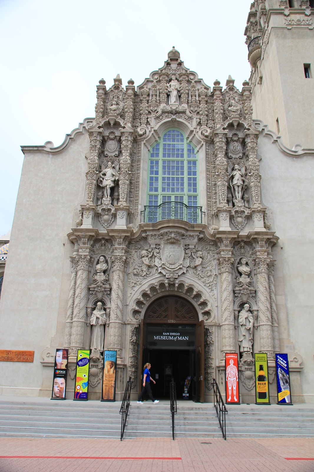
As it is raining during the morning of our first day, we go to the Balboa Park area to visit the Natural History Museum, it was excellent as expected. We returned on another more sunny day to visit the California Building which houses the “History of Man Museum”, the Botanical garden and other sights.  I also took a tour of the tower at the California building which involves going up many steps and a spiral staircase. It doesn’t take you all the way to the top, but close and you do get a good 360 degree view.
Balboa Park was initially built for the 1914-1915 Panama-California Exposition and years later was reconstructed and expanded for the 1935-1936 California-Pacific Exposition.  There are only about four of the original 1915-15 buildings, but much has been reconstructed to duplicate the originals.  There are about a dozen museums here including the famous San Diego Zoo.  We only plan to go to a few of the museums and are passing up on the Zoo as it is so expensive and we are not Zoo fans.


Beautiful pond with the Botanical building in rear


The Museum of Art, the building is also art


The dome of the California Building is art !


Museum of Man in the California Building


Museum of Natural History Dinosaur exhibit


Museum of Man exhibit


View from the top of the California Building


San Diego Transit System
Our highway ride across the city to Balboa Park was not much fun so we decided to try the San Diego’s transit system.   We found that San Diego has an impressive new light rail transit system.  We drove to the free park and ride lot at E Street station and then took the blue line trolley to the last stop at America Plaza.  It cost us $5.00 round trip and it was a short walk to the USS Midway Museum.  It took us through the central downtown area to get some of the local flavor.  We walked past the Santa Fe train depot which is fully restored with beautiful roof cupola tiles.  We went inside to check it out and happy to say it remains a key element of San Diego’s transit system and Amtrak.


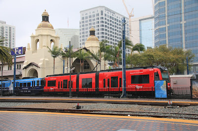
Trolley cars in front of the Santa Fe Depot


The Santa Fe Depot's cupola


Interior tiled walls


USS Midway and Embarcadero
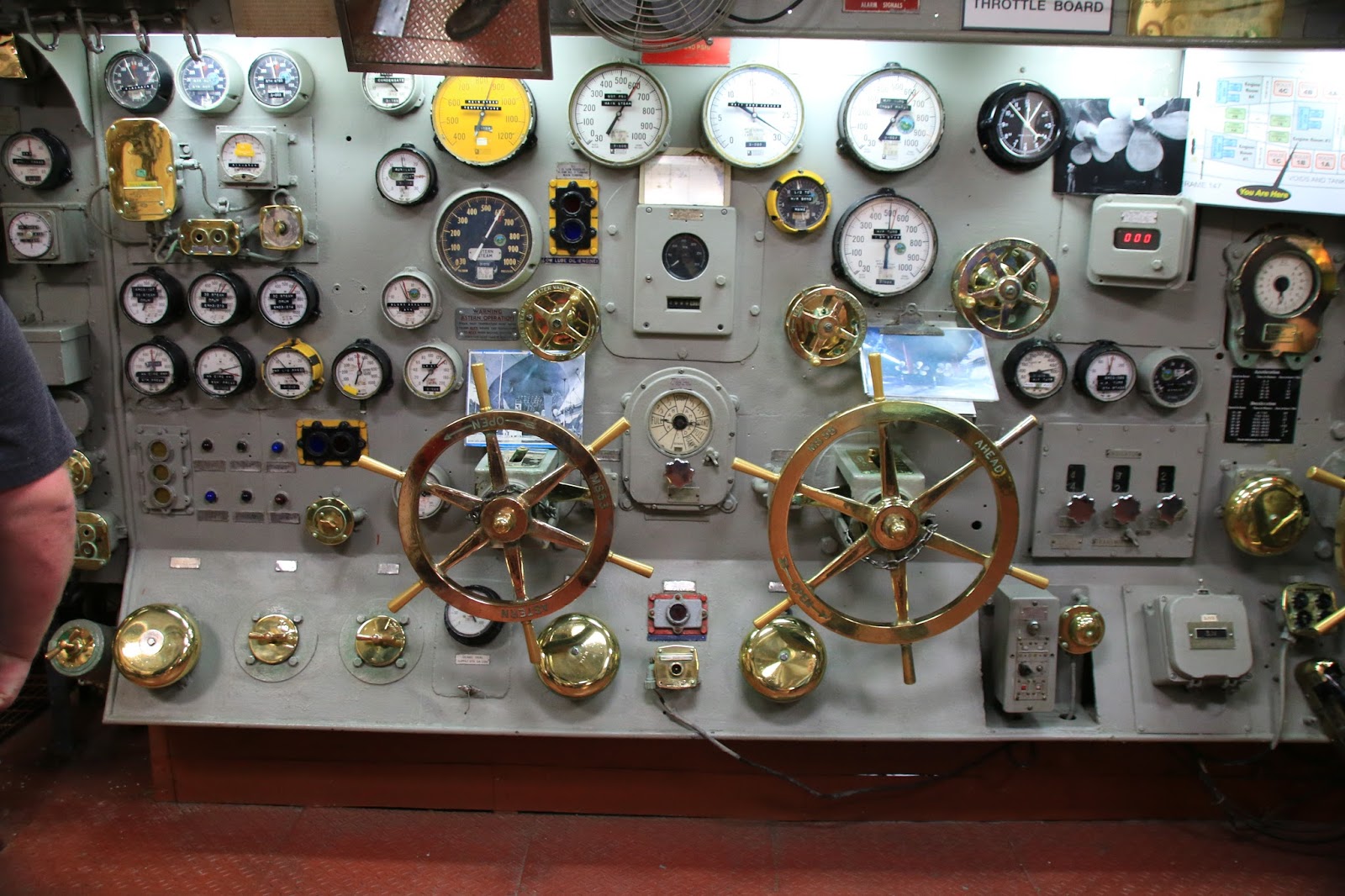
I am, as a rule, not a military fan unless it goes back to the days of George Washington.  I do however have a fascination for the vehicles of war and the stories of courage and valor.  The USS Midway is probably one of the most impressive military museums in the world.  They have actual sailors and fliers who were stationed on the ship and flew the aircraft answering questions and explaining things.  We listened to a retired pilot with a couple hundred combat take off’s and landings from the carrier explain how it worked.


Plane on display inside carrier


This would be your bed on ship


A pilot's war map from the Vietnam era


Control panel in the engine room


Fighter jet on the flight deck


In Viet Nam, I was in a Helicopter company that flew
a similar helicopter, I used to hear them all day


The USS Midway


Statue in park adjacent to the USS Midway


Bob Hope exhibit from the Viet Nam era, there was audio of
one of his USO shows, brings back memories


Retired pilot explaining how to take off and land from the Carrier


The Star of India, the Worlds oldest active ship


Old Town
Old Town is the actual birthplace of California which initially was a Spanish settlement started in 1769.  Eventually the town was relocated as San Diego to be nearer the bayfront for shipping and commerce.  The original Old Town was abandoned, fell into decay until it was resurrected and restored and as the Old Town State Historical Park in 1968.  The present town adjacent to the State Park is now a popular tourist attraction with many shops, hotels and restaurants.  The State Park has done a good job of restoring and rebuilding the historical village.


Dancers at Old Town


Mission and Pacific Beach
We drive to the Beach area where we walked the paved boardwalk, checking out the sights, the surf and the surfers.  It has a real shore town feel to it with lots of small beach rental units, beach bars, restaurants and sort of a dirty, gritty feel to it, like the Jersey shore.  The hardest part was dodging all the runners, bike riders and skate boarders on the boardwalk.


The boardwalk along the beach


Lots of restaurants and bars


Lots of surfers


A rice ride


Gaslamp Quarter
The Gaslamp Quarter of San Diego is an architectural gem and also the premier dining, shopping and entertainment district of town.  It’s one of those places that you could go back to over and over.  I see lots of live music venues in this area and I managed to check out a couple of them.


The gate to the Gaslamp Quarter


The Balboa


The Yuma Hotel


Architectural views


Simon says coffee shop


Barrio Logan and Chicano Park
I find my way to the Barrio Logan area that I had seen from the Trolley to check out the impressive murals along Harbor Drive.  This eventually turns into a major find, purely by accident.  First, I come upon a great coffee shop for a Mexican Mocha, then down the street find an impressive small park.  This area once had a tuna cannery which employed many of the  locals and the park is a monument in their memory.  It is nice to see a neighborhood that takes pride in and remembers its past.
I then found the “mother lode” of mural parks a short distance away.  Chicano Park is not even listed as an attraction in the Moon San Diego tour guide, but to me is a “must see” attraction.  This park came about during the 1960’s during the period of heightened civil rights activism.  The local residents, predominately hispanic, became tired of the city taking away their neighborhood with highway and bridge construction and zoning changes without any public hearings.  The locals rebelled and took over the park when the city attempted to construct a building there.  This ultimately was resolved, the park was saved and a huge mural project was started. This has culminated into the largest collection of outdoor murals, (72), in the country and the park is now listed on the National Register of Historic Places.  The general theme of the murals is Spanish, Mexican, Indian, (Californio) heritage, independence and civil rights.  I will admit a few of the murals could be considered somewhat revolutionary.  Again, it’s nice to see a neighborhood with this kind of passion for protecting it’s culture.


Murals do tell a story


Tuna Cannery history remembered


Great sculpture in the park


Chicano Park murals cover all the highway pilars


United Farm Workers mural


Chicano history mural


This is one of my favorites


They go on and on throughout the park


Coronado Island
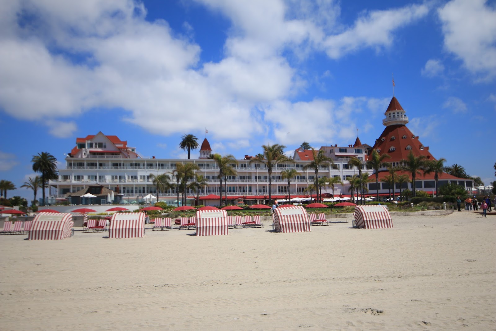
Coronado Island is a narrow strip of land in San Diego Bay. We stopped at the Silver Strand State Park for a beach walk, very scenic and peaceful with no crowds.  We then continued on to the town of Coronado with it’s world famous historic “Hotel del Coronado”.  We toured the grounds of the Hotel which are world class luxurious and then walked out onto the beach.  The Hotel opened in 1888 and is undoubtably one of the grandest Hotels in America.  We leave Coronado over the spectacular Coronado Bay Bridge with far reaching views in all directions of downtown San Diego.


View at Silver Strand State Park


Interesting flow lines in the sand


Sand Dollar art


The Hotel del Coronado


View from the beach


Sand castle on the beach


Dining
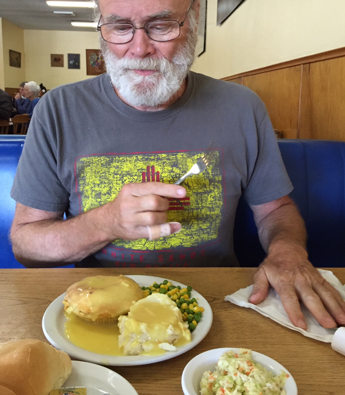
San Diego has endless classy dining possibilities, but I have little interest in expensive fine dining. I have more simple tastes such as Chicken Pot Pie.
I saw great reviews of a place called the “Chicken Pie Shop” and had to go. We didn’t exactly have high expectation and I wasn’t sure what Twinkles would find for her vegetarian pallet.  Happy to say, this restaurant far exceeded all our expectations !  The place is nothing to look at but the food was simply great !  The chicken pie was chock full of real meat with a nice homemade crust.  It came with mashed potatoes, gravy, cole slaw, corn and peas, rolls and a slice of fruit pie.  Twinkles had a beautiful fresh ripe fruit salad which she said was one of the best she ever had and for only $6.  Our total bill was $16 and it definitely is going on this years best restaurant list.


Another find was the Hans and Harry Bakery in Bonita, one of the best !


Getting ready to dig in


Almost wished I ordered this salad


House of Blues
The reason for going to the House of Blues was to see a local blues master, Robin Henke, play.  He plays there on a regular basis and was beyond great, playing mostly Delta country blues on an assortment of vintage 1920-1930 guitars.  He also told interesting stories about the songs and gave a short history lesson on the various blues players and their styles.  He is a native of San Diego who has been playing playing and teaching for decades and I don’t believe I’ve ever seen anyone play this style of music any better.


He's a great one !


Patrick’s Gaslamp Pub
A  few blocks away is another noted music club, Patrick’s Gaslamp Pub.  It’s an old Irish Pub that originally opened in 1933 when it was the red light district of San Diego.  It is situated in the Keating Building built in 1890 and was one of the earliest places to hear live music in the city.  They have now stuck to that tradition for 75 years now.  I went to see the "Fuzzy Rankins Band" who were chosen by the local blues society to represent the city in the International blues challenge in Memphis.  They were good but play more of a danceable style of blues, but not my style.  I didn’t feel comfortable in there and I didn’t see much Irish about it, so I left after one beer.   

I was just wandering around and heard the music at " The Field Irish Pub", it sounded good and the place appeared really authentic.  It was 100% Irish, lots of Guinness and Jameson.  There were two guys playing traditional Irish music very nicely, the beer was good, the atmosphere was nice, it felt good.


Traditional Irish music rocks !


Cabrillo Point
We rode along the San Diego waterfront on Harbor Drive north past the Navy yards, the convention center, center city, the embarcadero area, huge marinas and the airport.  It was hard to stay focused on the road.  This is one of the greatest natural ports in the world and it is filled with sea vessels of all kinds.  Our destination, Cabrillo Point, is where it all started in 1542 when Juan Rodriguez Cabrillo and his flotilla sailed in, claiming it for Spain and describing it as “a closed and very good harbor”.  What would Cabrillo think if he could see it now ?  

Cabrillo Point is located on a peninsula that rises 422 feet above the sea with strategic views of San Diego.  As a result a lighthouse was constructed here in 1854 as a navigational aid and military installations were installed for protection of the harbor during the WWI and WWII.  A military presence continues today on the end of the peninsula.  The views of the city and harbor from the Cabrillo Point are quite spectacular !


The restored old lighthouse


The view from the Point


The Cabrillo Monument


Model of Cabrillo's ship


Navy ship going out to sea


Bird Rock and La Jolla
We rode to the Pacific Beach area and then north along the coast stopping in “Bird Rock” to admire the beautiful beach homes and a stunning vista point on Neptune Place.  A short distance away we found Windansea Beach, parked and took a walk along the rocky shoreline and down onto the sandy beach.  We then continued to La Jolla where we parked on Coast Boulevard adjacent to La Jolla Cove.  There were hundreds of Seals and Sea Lions sunning on the rocks at La Jolla Cove and an equal of number of tourists taking photos and selfies.  We then walked around Point La Jolla along Eilen Browning Scripps Park with incredible views all the way.  Afterwards, lunch in La Jolla at the Living Room.


View from coast in Bird Rock


Another Bird Rock view


I'm calling them seaweed floats, they are real and very artistic looking


Seal yawning at Point La Jolla


View at the Point


Great views in every direction


Another coast view


Hundreds of Seals and Sea Lions

We thoroughly enjoyed San Diego except for the highways and drivers.  The natives here may be nice people but put them behind the wheel and they become evil. If you put your turn signal on to switch lanes as they are coming up on your right, they will speed up to cut up off, deliberately.  At first I thought it was accidental, but it happened over and over.   I believe it’s time for me to go where it’s a bit more relaxed ?


Next stop is Adelanto, California;
Twinkles and Slick