March 24 - 30, 2015:
 |
| The Banana Yucca's in the campground are stunning |
I finally weighed the RV at the Pilot truck stop which does not give you the weight on each wheel, but the weight on the front and the rear axle and the total weight. The good news is the weight ratings for both front and rear tires are OK. The bad news is that we are about 280 lbs over for the vehicle GVWR of 14,500 lbs. That's actually better than I expected, we can live with it, but there are a few items that could be dropped off along the way.
We drove separately again taking I-10 east to Deming, then route 26 north to Hatch, NM (capital of chilli) where I stopped and walked around taking a few photos. It was then route 25 south to a rest area just north of exit 19 where we hooked the Jeep up behind the RV and towed it into the Leasburg Dam State Park. I need longer safety chains, but otherwise all seemed good and I could hardly tell the Jeep was back there.
 |
| World Famous chilli burgers |
Leasburg State Park is adjacent to Leasburg diversion dam which was built in 1908 on the Rio Grande River for irrigation. We have a pull through site with electric and water, a covered picnic table and a fire pit. There is a bathhouse with very HOT water and a dump station. It is so very quiet here, nothing like the truck stop.
Within a mile of Leasburg State Park is the Fort Selden Historic Monument. It's mission was to keep the peace and protect the Mesilla Valley from the Apaches. The Apaches were mostly decimated by this point however and there was not much action. It seems that more soldiers were killed in town by local bad guys that were killed by Apaches. The fort was eventually abandoned, the locals took everything useful including the roofs. As a result the adobe walls were left to the elements are mostly eroded away now.
 |
| Fort Seldon before |
 |
| Fort Seldon now |
Las Cruces, New Mexico is the 2nd largest city in New Mexico. We explored the Main street area where a farm market / craft market happens on Wednesdays and Saturdays. Saturday was much larger although mostly crafts and food this time of year. There are several restaurants, a great bookstore, a few theaters and three museums also in this area. We found an excellent mexican cafe, Rosies Cafe, for lunch nearby. We also found The Mesquite historic district with many old original adobe buildings that were interesting.
 |
| Rio Grande Theater |
 |
| Another colorful Theater on Main Street |
 |
| Aquas Frescas is great stuff |
 |
| Very interesting food truck with boat |
 |
| Mesquite historic district sign |
 |
| Symbol of friendship, have a coke ? |
 |
| Our Lady of Health Church |
 |
| La Nueva Casita Cafe |
Another very interesting area not to be missed is the old Mesilla area in southwestern Las Cruces. Mesilla was originally where the action was and where history was made. It was larger in population than Las Cruces and on the opposite side of the Rio Grande River. The town hasn't moved, but the river did, it changed course at some point so that Las Cruces and Mesilla on now on the same side. It was disputed land between the US and Mexico until the Gadsden purchase officially made it part of the US. Several of the original buildings are still standing and in use. The present Church, the Basilica of San Albino, built in 1904 sits on the exact site of two previous churches built. The town has a scenic old courtyard and most of the central area is converted into restaurants and stores.
 |
This was a courthouse where Billy the Kid was
sentenced to hang |
 |
| A very old building in Mesilla |
 |
| The Basilica of San Albino |
 |
| An original town gate |
 |
| Painting on a building |
They are several good hiking location near Las Cruces. We have an interesting short hike around the state park campground that takes you down to the Rio Grande River in sight of the Dam then along the river through a picnic / beach area. The Rio Grande is just a trickle of water here, but it becomes a raging torrent at times during the monsoon season. They have a on-going project to remove the evasive (non native) Salt Cedar trees from the Rio Grande River banks. The Salt Cedar trees were originally planted to stabilize the river banks and prevent erosion. It seemed like a good idea at the time, but it grows so fast and dense that it crowds all other vegetation out and is now a menace.
 |
| A beaver Dam in front of the Diversion Dam |
 |
| The Rio Grande River |
 |
| The dreaded Salt Cedar is ugly ! |
The Dripping Springs Natural Area is administered by the BLM. The area was bought and saved from development by the "Nature Conservancy", (an incredible organization), who then worked a deal to turn it over the BLM. This is part of the Organ Mountains which are very pointed prominent peaks on the Las Cruces landscape.
We first took the La Cueva trail which takes you to a cave which was once inhabited by ancient indians where many artifacts were found during recent excavations.
It latter was inhabited by a hermit, Augostini Justiniani, who was actually born of Italian royalty. He was a religious man who traveled from Europe to South America, Cuba, Mexico and finally the west extensively and was reputed to perform miracles. In the end he was murdered in this cave in 1869.
 |
| Interior of the cave |
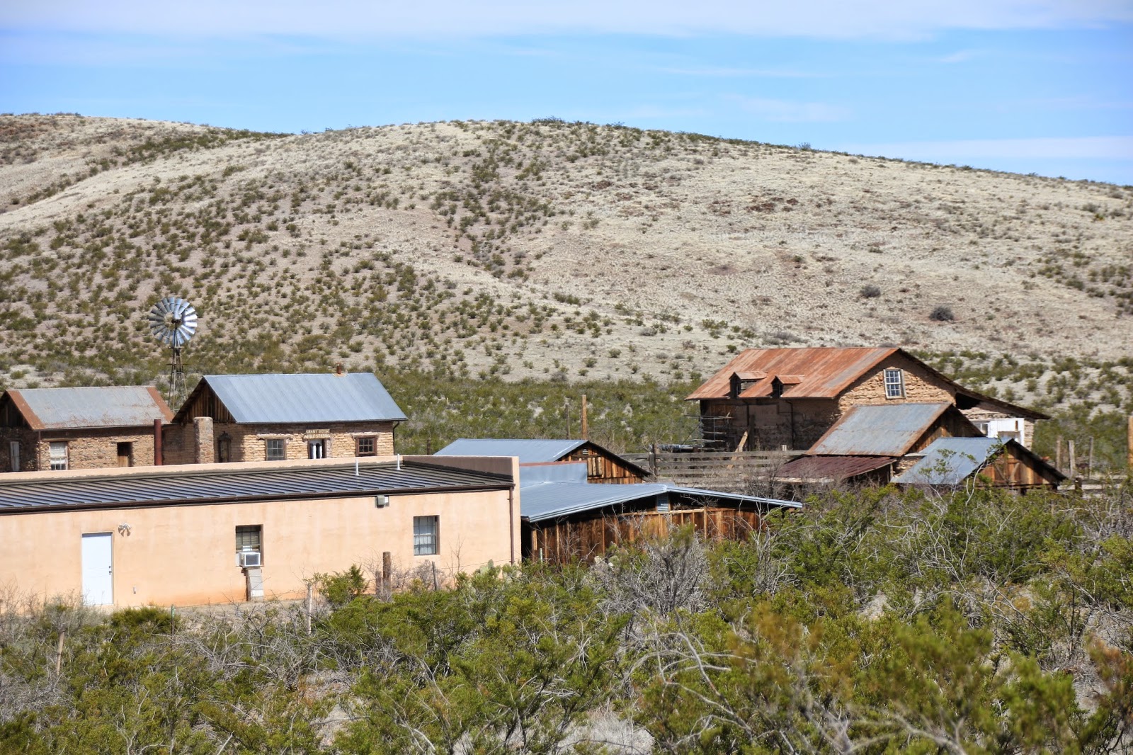
We then did the Dripping Springs trail which takes you to the ruins of the Dripping Springs Resort, originally built in the 1870's by a Colonel Eugene Van Patten and called Van Patten's Mountain Camp. The camp was very popular around the turn of the century with many famous people such as Pat Garett and Poncho Villa as guests. The ruins of several large stone building remain.
 |
| Old corral area |
 |
| One of several old stone ruins |
 |
| Another old wall still standing |
A second hike was taken (another day) from the Aguirre Spring Campground located on the eastern side of the Organ Mountains. It is another BLM managed natural area. We took the Pine Tree Trail which was a 4 mile loop that has about a 1,000 foot elevation gain. It goes up through an area with many old Alligator Juniper trees, Gray Oaks, Sotol's, chollas, Ponderosa Pines and beautiful vistas in all directions. We were able to see far across the Tularosa Basin and White Sands National Park from the trail.
 |
| A trail view into the Tularosa Basin |
 |
| Lush green trees along trail |
 |
| Twinkles striking a pose |
 |
| Beautiful mountain views |
Friday night I went to the Blue Moon Bar in Radium Springs about two miles from the campground. It is actually a fairly nice place with a large outside patio area with two concert stages. A band called "Saturday Night Special" was advertised to play there. I figured this to be some local country band, but when I checked on the internet, this band has 4 original members of Lynyrd Skynyrd. I am not a big fan of Lynyrd Skynyrd and their redneck attitude, but have to admit they made some great music. It is basically a cowboy bar and the band was very accommodating, they went from Jimi Hendrix to Hank Williams without missing a beat and sounded at home playing both. I don't really think the original members are still in the band, but they could play the Lynyrd Skynyrd stuff perfectly and were a real journeyman working band that could play about anything better than average.
Saturday after the farmers / craft market we visited the Art Museum, Nature and Science museum and the Railroad Museum. They were all very small museums but interesting.
 |
Interesting exhibit on a new National Monument
called the Permian Trackways near Las Cruces |
 |
Jerry Mac Donald was the one to discover the site
that holds huge numbers of prehistoric Dinosaur tracks |
 |
| The Las Cruces Depot is now a museum |
 |
| A classic Santa Fe Chief advertisement |
We just couldn't leave La Cruces without a return to Mesilla for lunch at the La Posta de Mesilla. The food and service was very good but the ambiance of the place was beyond compare.
 |
| Entrance |
 |
| View from our table |
 |
| Old painting of the Restaurant |
 |
| In the Lobby wall |
Next stop is Alamogordo, NM,
Twinkles and Slick