Saturday, April 29, 2017

Wichita, Kansas

April 25 - 26, 2017:

Again I am faced with several travel route options, the fast way through Wichita, Kansas or a slower route taking back roads in Kansas.  I almost always favor the back roads.  We start on route 35 north, then exit onto route 177 which takes us across the border into Kansas.  It is a windy day, but it’s a tail wind, I like that.  In Kansas, the wheat fields start immediately, but with many islands of oil pump jacks.  We take a short break in South Haven, Kansas, then continue to Wellington where we turn onto route 160.  After about 10 miles we turn onto route 49 north to 39th street where the Lake Afton County Park is located in Goddard, Kansas.


South Haven's big water tank

Yearout Tanning where "We will tan your hide"

They call these grain elevators "Cathedrals of the Prairie "
and I I felt his one really did look the part


Lake Afton is a fairly large fishing and boating lake, but nothing very exciting or well maintained.  The park is a bit weird, at the park office they gave us a windshield sticker for the RV, no campground map and no information about the Park.  I suppose we should have asked more questions ?  The windshield sticker had # 27 on it so we figured we needed to find campsite # 27, but when we got there it was a terrible site.  We then realized the # 27 was our departure date, that we could pick any open campsite, but we didn’t see any with water hookups.  We then start riding around the lake to the several small campgrounds looking for a better area with a water hookup.  We were not impressed, we saw mostly beat up old campers parked and rough washed out roads.  We eventually find a decent campsite but no water hookup, the only ones are in a group area.  No problem, we have some water in our tank, water is available and our water pump is fine.  At $10 a night with a shower room and storm shelter nearby (that’s comforting).


A dark and dreary lake view

And a bright sunny view

There is a police training facility adjacent to the campground and we kept seeing police cars with flashing lights pulling over cars inside the park area.  I was beginning to wonder what was going on here, high crime area?, but then we realized it must be part of the Police training program. 

Goddard, Kansas is not very interesting, in fact it’s boring, although it’s tidy and clean with the usual shopping strip businesses outside of town. Goddard is almost a suburb of Wichita, Kansas as it is only about 5 miles to the city limits.  

The forecast is dismal with a rainy cold front coming in and to think I was complaining about the heat and dust a few weeks ago.  It was a windy cold night with morning temperatures in the low 40’s.  We head for downtown Wichita to the Old Town area.  This was originally a vibrant warehouse and industrial area, which gradually died out, the buildings becoming abandoned.  A city project was started to convert these into office space, apartments, restaurants, bars as an entertainment / arts district of the city.  The whole area is now reborn and appears to be very successful. Nearby is the huge impressive Santa Fe Union Station which is now undergoing a full restoration.

https://en.wikipedia.org/wiki/Wichita,_Kansas


Interesting Motel sign


The Orpheum Theater 

Old Town street banners

Interesting historical panels on many of
the companies that were in the Warehouse district


Everything is brick


Union Station is very impressive

Old Steam Engine on display at Rail Museum

We stopped for lunch at the very popular River City Brewing which was excellent on all fronts, my wood fired Pizza and Twinkles Baked Macaroni were both winners.


River City Brewing entrance

We also visited the “Keeper of the Plains” Sculpture and Bridges at the confluence of the Arkansas River and the Little Arkansas River. This was a sacred place for the Indians.  It all sounded a little hokey to me, but when there it was very impressive.  At night it is illuminated at times by fire drums at the base.  

Totem Pole at the All American Indian Center adjacent
to the "Keeper of the Plains"

There are two identical bridge spans across the two
rivers here


Several informative Indian exhibits on the Bridge Plaza


Looking downstream towards center city

One Bridge from a side angle

The 44 ft tall "Keeper of the Plains" sculpture

Geese in the water under bridge

Our last stop was the Delano Historic area which originally was a rough and tough cow town at the end of the Chisholm "cattle drive" trail.  It has now become a trendy dining and entertainment area with the historic "Window in Time" Clock Tower.

historicdelano.com/HistoricDelano/history.php


Tattoo parlor mural

This was once the Chisholm "Cattle drive" Trail

Now home of the Bikeman

The place to go for Billiards

The place to go If your feet hurt

Roundabout around the Clock Tower

Historic sculptures are on all four sides
of the Tower Monument


Next stop is Manhattan (The little Apple), Kansas;
Twinkles and Slick

Friday, April 28, 2017

Guthrie, Oklahoma and the Land Run

April 23 - 24, 2017:

I had three potential travel routes today, the faster route going through Oklahoma City,  the next faster route taking a toll road around Oklahoma City or the slower more country route going through a couple of towns.  I took the slow road, but no big deal as it was only a two hour ride.  I had to make one stop in the town of El Reno, on original route 66 for this very cool Oklahoma route 66 mural.


Classic Route 66

This route went through miles and miles of green farm lands peppered with oil rigs.  There was a small very acrobatic crop spraying aircraft flying at low level over the fields, with a very quick lift over the highway followed by a sharp turn and another dive down over the fields.  It looked like a risky business to me.  Also several dead Armadillos along the highway, they seem to be like rabbits, not very street smart.

Our destination, Guthrie, Oklahoma started out as the Deer Creek station of the Southern Kansas Railroad in 1887.  In 1889 when Indian reservation land was opened up for settlers in the "Land Run", approximately 10,000 settlers arrived to homestead in a very short period of time time.  The town name was changed to Guthrie for jurist John Guthrie, absolutely nothing to do with Woodie Guthrie.  Guthrie immediately became a bustling city and the Capital of Oklahoma Territory and then the Capital of the State of Oklahoma in 1907.  As a result, Guthrie has a huge number (they claim 2,000) of impressive brick and stone buildings built mostly in the late 1800’s to early 1900’s and is one of the largest designated Historic districts in the country.  Eventually, nearby Oklahoma City  developed more industry and political clout and was elected the Capital of Oklahoma in 1910.


The Victor Hotel

The Pollard Theater

The State Capital Company building

Downtown view

The DeSteiguer Building


Relieves fatigue !

The Temple of the Scottish Rite of Freemasonry is huge 
and one of the largest in the country


The Gaffney Building

The DeFord Building

It had to be absolutely insane and out of control on April 22,1889 when the "Land Run" was conducted. The cattle ranchers had battled against the policy to open the land for settlement as they had been grazing their cattle on this land. The land run was started with a canon blast and then everyone with map in hand rushed off to claim an open parcel of land.  The “sooners” jumped the gun and went out ahead to claim choice parcels, hence the “Oklahoma Sooners” monicker.


Site of the Land Office that was a small wooden frame building
on a hill top where thousands of settlers lined up to register
their land claims


We didn’t do much on this short two day stop as most of the downtown businesses and museums were closed on Sunday and Monday.  Many of the antique stores  were open on Monday enabling me to wander around buying some old post cards.  I also bought a 1988 commemorative pin for the 89er celebration in Guthrie.  Each year they have a new pin for this annual event commemorating the1889 land run that started the city of Guthrie.


I found a rustic bar, the Roc-A-Way Tavern, close to the campground totally by accident, love it when that happens.  It is an old stone building built in 1932 by a Federal Marshall and his prisoners.  It's actually a beautifully constructed building.  According to on line reviews it is sort of a biker bar and a the place to partyin Guthrie, although on this evening it was quiet.  National Geo's Mudcats was filmed there in 2012 (something to do with fishing) and they hold a Catfish noodling ? tournament here each year.  I guess I need to get up to speed on "Noodling".


The Rock-A-Way exterior

And the unusual entrance sign

We would have liked to explore more in Oklahoma City and northern areas of the state, but Tornado season is approaching and I don’t want to be here.  As a result we are moving on into Kansas.

Next stop is the Lake Afton County Park near Wichita, Kansas;
Twinkles and Slick

Wednesday, April 26, 2017

Red Rock Canyon, Indian Tribes and the Oklahoma Land Run

April 19 - 22, 2017:

It was 140 miles struggling with gusty winds all the way.  We crossed over into Oklahoma after about 30 miles and it became wide open flat green cattle ranches for miles and miles interspersed with oil pump jacks.  We passed through a couple of areas that I would like to return to, another time perhaps ?  Also a town, Anadarko, that I return to later.

Our destination, the Red Rock Canyon State Park, in Hinton, Oklahoma is a small park situated in a beautiful red rock canyon.  The canyon walls here are a popular rock climbing and rappelling site.  This area once was a winter camp for the local indian tribes as it is very protected with a creek flowing through it.  The canyon also became a landmark for travelers on the California Road during the Gold Rush days.  The California Road trail in the park follows a section of the old road where you can still see the wagon ruts.  I did the trail and have a hard time believing they used this as a road although in a few places the cuts in the rocks do look like wheel ruts.  Another trail in the park, the Rough Horsetail trail, goes through a marshy area covered with Horse -Tail Ferns that were used as pot scrubbers by the pioneers.  The trail ends at a pond created by water pouring off the end of the box canyon.


The road through the State Park

There are many areas where steps are cut in the
canyon wall to climb up, but way to vertical to do without

ropes unless you are spider man


This Dam on the creek creates a small lake

View from the canyon rim

Many great wildflowers along the trails


Horn Tail Fern

Pond at trails end

Wagon ruts on the California Road

Each evening at dusk we here the distinctive hoot of a Barred owl who sits in a tree top in the canyon behind our campsite.  Originally I thought it was one Owl, but later I heard a second Owl in the distance and realized they were communicating back and forth.

The town of Hinton is all about agriculture, ranching and oil.  Their claim to fame is that they had the first Rodeo in Oklahoma.  There is now two Casino's and a Hotel situated within 5 miles at the junction of interstate 40.


First Rodeo in Oklahoma

Downtown Hinton 

Hinton mural

It’s wet and humid here, something we aren’t accustomed to anymore and rain and thunderstorms are forecast for the next two days.  As it was cloudy, we decided it was a good day to go to Oklahoma City to the Oklahoma History Center.  This is a great museum that covers with detail every aspect of Oklahoma history from the indigenous Indian days to the present time. After about three and a half hours we were worn out, this history is intense.  Our lives today are simple and very safe in comparison to the crazy goings on during the period of westward expansion, the cattle drives, the Indian wars, the relocation of the Indians to the reservations, the various broken treaties and subsequent land grabs by the settlers, the greed, the killings, the outlaws and then World wars.


Wiley Posts famous plane

Famous space capsule, I believe this to be one that
local astronaut Tom Safford flew


Buffalo Charley inherited from his father the designs of the "Tipi 
with the battle pictures" and his position as "calendar keeper" 
in which he updated  the Tipi paintings


The famous "Tipi with the battle paintings

Annual events were recorded with paintings on the Tipi

Settlers faced many hardships on the Land Run
but also had much oppurtunity for a better life


While the Indians way of life was taken away

It was a harsh environment and sometimes the settlers lost 

A total of 39 Indian tribes were relocated to reservations in Oklahoma and are still here. Looking at an early map, most of the Oklahoma was Indian reservations.  Many of these tribes had been decimated by war, starvation and disease and were unable to sufficiently inhabit the allotted lands.  This resulted in land deemed surplus that was taken back and opened up to settlers amidst much greed and corruption.  That's how the west was won !


Map showing Oklahoma Indian reservations
  
I have started to read “The last of the Mohicans” which is slow going and difficult due to the old flowery manner of writing.  It is really appropriate to much of what we saw in the museum exhibits and very appropriate to Oklahoma, which is sort of the repository for all the sad broken tribes of our countries Indigenous peoples.  Something to think about; for two centuries the Comanche tribe ruled a vast area here, as the Mohicans did in the east, for a longer period than the United States has to date, then they were decimated within a few decades.  If History does really repeat itself, our time will come ?

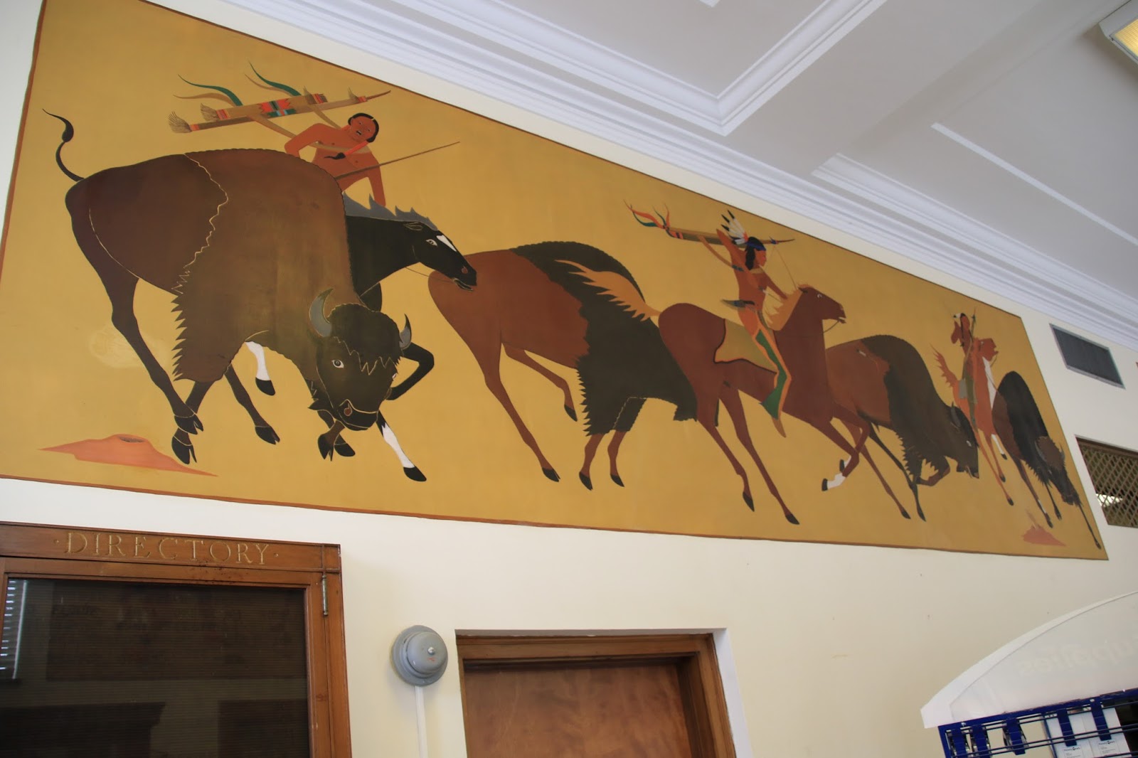
I travel back to the town of  Anadarko which is centered in Indian country.  It is the self titled "Indian Capital of the Nation" but from what I saw that isn't very flattering.  Anadarko is surrounded by the Wichita, Caddo, Lenape, Kiowa, Comanche and Apache reservations.  There are many attractive old buildings along its main street, but it’s definitely a poor town that has seen better days.  The Redskin Theater is still open but could use some help, while the Miller Theater a block away appears ready for the wrecking ball.


Main Street Anadarko

There are several murals in Anadarko

This is a great one

The Redskin Theater

Several buildings with nice stone and brick work

This is true !

I then wander into the Anadarko post office with a feeling it might contain some art work and find a treasure trove of 1930’s indian artist paintings.  When I ask the postal employee about them, he didn’t seem to know anything about them but offers a brochure on the counter that explains them.  They were done by a few local noteworthy Indian artists in the late 1930’s.


The Post Office

There are about a dozen mural in this style around the walls

They are all beautiful

It’s lunch time, I’m hungry and I see many people going into a nice looking cafe called the “Soda Fountain Eatery”.  Inside, I find out why everyone in town seems to be there, it’s that great.  

On the return a few miles outside of Anadarko, I pass the Delaware Lenape Tribe’s "Sugar Creek Casino".  I had no idea that a faction of this east coast tribe ended up here.  They were the original indigenous Indian tribe back in the New Jersey-NewYork, Pennsylvania area.  My fathers farm may have once been their land so I didn’t feel bad losing $10 in their slots.


Gold River Casino

I pass by the "Wichita and Associated Tribes" modern museum, it wasn't open, but took a look at the two traditional huts on the property.


Tribal seal

Wichita huts

Continuing on, I pass through the town of Binger.  It’s a poor farm town with one thing that makes it special.  It is the birthplace of Hall of Fame baseball catcher Johnny Bench.  They even have a Johnny Bench Museum in town.

The next stop was the town of Gracemont where I found a couple of sights.


Bailey's service station mural

Nice old tin front on building

I haven’t gone out for breakfast anywhere in a long time and the Main Street Cafe in downtown Hinton looked like the “down home” kind of place I normally like.  It turned out to be clean, friendly and the food was very good. In fact it was the best breakfasts I’ve had in a long time.

Original route 66 runs through the town of Weatherford about 20 miles from Hinton.  I went but was disappointed as most of the downtown buildings appeared to have been faced with newer bricks years ago.  Also there were no neons lights, murals, nostalgic signs and overall it was pretty boring.  In fact I didn’t see any much reason to take any photos, but I could't leave totally empty handed.


Route 66 theme Diner

The town of Hydro is nearby which I found to be way more photogenic with a huge grain elevator and a folksy central business district.


Grain Elevator in Hydro

And a classic small downtown

My tour ends with a stop at the Cherokee Trading Post where I leave with a souvenir Oklahoma tee shirt.


The Cherokee Trading Post

Since arriving in Hinton, we have had about 2 inches of rain, wicked winds, lightning and thunder storms with small hail. I keep reminding myself, we are in Tornado Alley, it can get much worse.  If it gets too scary for us, you may see us put in a long steady drive, North, East or West to get out of harms way. 

Next stop is Guthrie, Oklahoma;

Twinkles and Slick