October 4 - 8, 2014: Tucson - Flagstaff, Arizona
The Odyssey is finally leaving the driveway where it has been sweltering in the brutal Arizona summer heat for the past two months. We are going to Flagstaff for 4-5 days where it is about 15-20 degrees cooler (I hope) which should be a nice relief. We leave on Friday October 4th heading towards Phoenix but taking the 202 and the 101 loops to avoid traffic. Everyone hates the drive through Phoenix but it’s really no worse that most other major cities. I must say that I'm actually quite impressed with the highway planning in Phoenix, they have expanded travel lanes, added new loops and overpasses with very artistic sound barriers, good road signs and are keeping pace with the ever increasing population. Tucson on the other hand is way behind, but in some ways I’m OK with that, I really don’t want it to become another Phoenix, Unfortunately, it is already happening, the city planners can’t seem to say no to the developers and the city limits are rapidly expanding and the road are not.
Eventually, we get off the Phoenix speedway and onto route 17 north and it’s a relief to see open country and Saguaro Cactus again however the road is a handful in places, steep uphills with high speed curves. There is a major road construction project in progress however which is badly needed, but was causing a long traffic jam for many miles this day for no apparent reason. We eventually got through it to Flagstaff where we took routes 40 to 89 to the Bonito Campground where hoped to get a campsite, but unfortunately none were available. The camp host was very helpful and directed us to a nearby dispersed camping area, she also recommended that we check back on the next morning as likely there would be openings.

The dispersed camping area is in the Coconino National Forest and we had no trouble finding a spot along the dirt road road. Shortly after arriving however, the traffic along this dirt road picked up dramatically with every vehicle creating clouds of dust. We started to wonder, why so much traffic, where is everyone going?
In the morning we found the answer when we walked about a half a mile down the road to see many other off road campsites and a large parking area filled with cars for a hiking trailhead. We then returned to the Bonito Campground where we were able to get a campsite at half price with our senior America card, what a deal. We then drove to the nearby Sunset Crater National Monument visitors center, checked out the exhibits and then took a short trail into the Bonito Lava Flow.
The Sunset Crater volcanic eruption is amazing, it erupted between 1040 and 1100. The Cone is 1,000 feet high and one mile in diameter and its ash fall extends for approximately 800 square miles. The Bonito lava flow was about 100 feet thick and flowed for more that 6 miles. This area has had much volcanic activity and it is now believed that this is due to the area being at the boundary of the Colorado plateau where the Earth’s crust is very thick and the Basin and Range region where the crust is very thin. At this transition, faults develop which serve as pathways for lava to move to the surface. The nearby San Francisco Peaks are believed to have once been a massive single peak reaching 16,000 foot in elevation. It is believed that a massive explosion took place, similar to Mt. Saint Helens, resulting in several smaller peaks from the original Volcano. Humphreys Peak at 12,633, remains as the tallest Mountain in Arizona.
https://en.wikipedia.org/wiki/Sunset_Crater
 |
| Beautiful views near campground |
 |
| The Bonito lava flow is an amazing sight |


 |
| It's a crazy beautiful landscape |
We then drive approximately 13 miles further on the road through the National Monument to the Wupatki National Monument. The center piece is the Wupatki Pueblo which is a most impressive multi storied complex which archeologists believe, based on artifacts found, to have been inhabited by a well organized community involved in a lively trade network and elaborate ceremonies. The current Hopi people regard those who lived here to be their ancestors. However archeologist believe based on pottery found, that the Kayenta people occupied about half of the known area dwellings. It is also believed that between 1130 and 1160 as many as 3,000 people lived in this area. They were good farmers however tree ring dating shows that in the late 1100’s the climate entered a warmer, drier phase making life difficult and the last roof beam date was found to be 1225 which is considered to be the last occupation date. Unfortunately, much of the of the Pueblo area was closed for maintenance and we couldn’t see it up close.
https://en.wikipedia.org/wiki/Wupatki_National_Monument
 It's a massive compound

 |
| An artists rendering of what it would have looked like |
 |
| A beautiful scenic location |
 |
| The stone work is pretty amazing |


We then drove a few miles away to the Wukoki Pueblo with its elevated, solid rock foundation overlooking a wide flat area.
https://www.nps.gov/thingstodo/visit-wukoki-pueblo.htm


Back at the Bonito Campground, we find this to be one of the quietest campgrounds ever, (almost unreal) no children, adults or dogs making noise. There are no hookups here, but we have good sun for charging, ample propane and water in our tanks, all is good.
On Sunday morning, we drive through Flagstaff and then uphill for about 25 miles on a curvy mountain road to the Arizona Snowbowl. We are going to take the gondola ride to the top of the ski mountain and it appears that everyone else has the same idea, it was quite crowded. The road has a limit of 30 foot length for RV’s and trucks, so we are OK, but we didn’t see any RV’s on the road, very unusual ? I was a little disappointed by the ski area lodge, its actually kind of small, dingy and backwards. I expected more from a ski area that is reported to be the most expensive in the US. The Gondola appears to be brand new and the view from the top was great but only one short trail was open and no amenities at all. Back down at the base, we wanted to spend our $20 credit towards food for taking the $100 Gondola ride. We found no real food concession inside, but eventually found out how it works, you take a table outside and wait for a server to come round and take your order. It was very slow, we had to chase after a server to place an order, but after about 45 minutes or so we did get our order and it actually was very good.
https://en.wikipedia.org/wiki/Arizona_Snowbowl
 |
| The gondola appears to be very new |
 |
| It's straight to the top |
 |
| An impressive looking ski map |
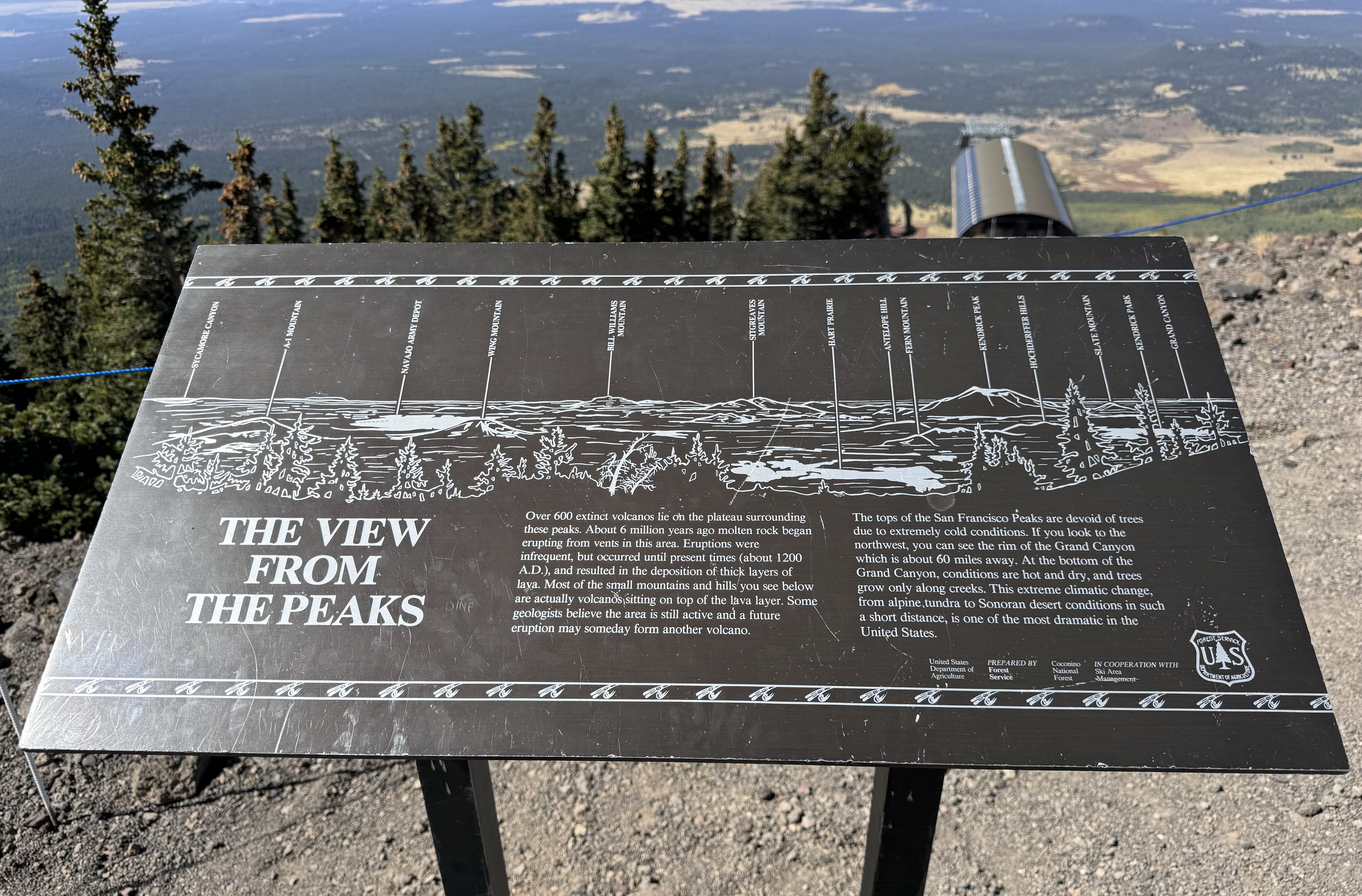 |
| The map shows the extensive number of area dormant volcanoes |


Back at the campground, we take a trail which runs through a forested area along the Bonito Lava Flow with great views, interesting plants and geology.
 |
| The Ponderosa Pines are beautiful |
 |
| This lave flow occurred about 1,000 years ago, but still looks fresh ? |

 |
| This cactus seemed a bit misplaced here |
 |
| Love the contrast between the lava, the green plants and the burnt tree On Monday, our last day we leave the campground and head south on route 89 to 17 and then 89A to Sedona, AZ. Route 89A is actually not recommended for RV's, it’s very narrow with many hairpin turns, but the views and scenery are amazing. The problem however is that it’s extremely hard to find a place where you can pull over and park. As the fall foliage season is happening, the parking areas and trails are currently filled. It’s actually kind of frustrating, seeing bits and pieces of the colorful rock formations through the trees, but being unable to stop and explore. After going through downtown Sedona and what seemed like endless roundabouts we get back on route 17 south to the exit for Cottonwood, AZ. We go directly to the Dead Horse Ranch State Park Campground where we get a campsite. |
We then drive to old downtown Cottonwood, park and explore the Main Street area which has a good mix of restaurants and shopping. We have a great lunch at the Old Town Cafe and then return the campground. It seems that the wine growing industry has become very popular in this area much to my surprise, I wouldn't think the climate would be right ?
It’s a hot day, about 100 degrees as we put out the awning for the first time and run the air conditioning.
https://en.wikipedia.org/wiki/Cottonwood,_Arizona
 |
| Beautiful ceiling inside the Old Town Cafe |
 |
| Liked the "no attitudes" sign |
 |
| Interesting mural on the side of the Red Rooster Cafe |
 |
| Another artistic one |
Tuesday morning, it’s time to head back to Tucson, route 17 south with no traffic delays this time, taking the 101 - 202 loops and route 10 without incident and arriving back in Tucson in mid afternoon.
That all for now, we need to get this machine out again in a month or so for a longer trip.