June 5 - 8, 2016:
The drive today was mostly on Route 97 north through farmland that was mostly hay fields and cattle range. It passed through the interesting small farm towns of Shaniko, Kent, Grass Valley and Moro which I found cause to stop at. I’m listening to a old 10,000 Maniacs CD I bought back in Redmond at the thrift store for 25 cents, I always did like them especially that song that starts; “These are the days you’ll remember. Never before and never since, I promise, will the whole world be be warm as this.”
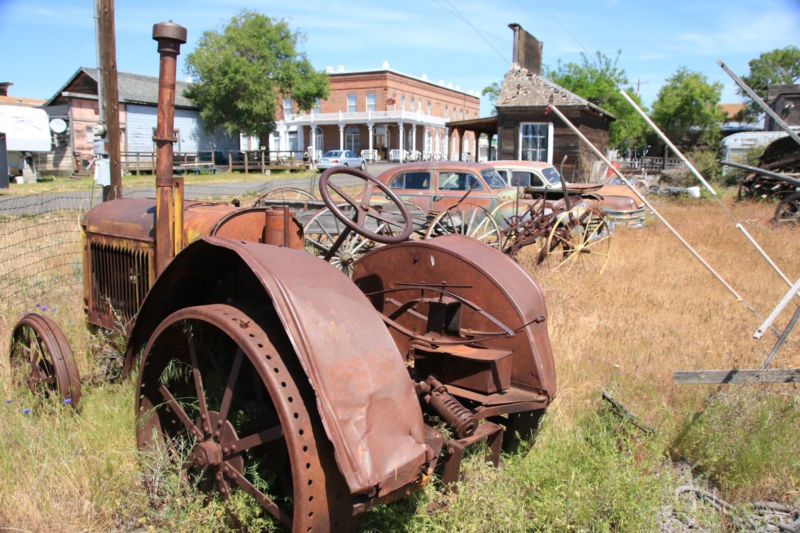
The town of Shaniko was a huge Wool center in its day, said to be the largest in the world, with several huge warehouses and a railroad connection. This area was a major sheep ranching area, but eventually the wool market died and the town died with it becoming almost a ghost town. It is being resurrected today as many of the original buildings remain and the whole town is essentially a museum. The Shaniko Hotel is so huge, it must have been one of the largest Hotels in Oregon when built. The towns of Grass Valley and Moro also had an old time country feel to them.
 |
The Shaniko Hotel was a destination in it's day
|
 |
Nothing seems to have been discarded in this town
|
 |
Nice building in Grass Valley
|
 |
Last gas for 67 miles
|
 |
Beautiful mural in Moro
|
 |
Moro was another railroad town
|
It is super hot here at the Deschutes River State Recreation Area, the thermometer is around 100 degrees, looks like we will be running the AC. We had anticipated the heat and went for the campground with electric and water hookup. Our campsite overlooks the Deschutes River with lush green grass and shade trees. The Deschutes River enters the Columbia River a few hundred feet away and the pioneer Oregon Trail came right through here. This is where the pioneer wagons would have forded the river, pretty scary, I wouldn’t want to do it. The sign says that the indians would help the settlers across for something like a brightly colored shirt.
 |
Loved the tree shadows at the campground
|
 |
The confluence of the Columbia and the Deschutes Rivers
|
 |
The Deschutes River from the rail trail behind campground
|
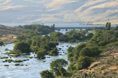 |
The Desschutes River flowing into the Columbia River from the trail
|
 |
I loved the colors of the rye grass
|
 |
Great trail view in the evening light
|
Morning coffee outside on the grassy banks of the Deschutes River watching the birds on the river is the proper way to start a day. The Deschutes is a big river in its own right, it flows for 252 miles and is a major tributary of the Columbia River. The Columbia is the largest river in the Pacific Northwest at 1,243 miles long and has the greatest flow of any North American river into the Pacific Ocean. There are 14 Dams that produce 44% of the total US hydroelectric generation.
The major city here is “The Dalles” which is a true “crossroads of history” kind of place. The Dalles is a strange name for a city, it originated from the French Canadian fur trappers who though the rock lined rapids and narrows in the River resembled flagstones and called the place Les Dalles. The Dalles is on the Columbia River, was a major native American settlement and trading center, Lewis and Clark traveled through here on their expedition and it was the end of the Oregon Trail. The historic downtown area has several great old buildings, lots of historic themed murals, many breweries, restaurants and shops.
 |
Many historic murals in downtown
|
 |
Nice spot for lunch
|
 |
The Granada Theater in downtown Dalles
|
 |
A wheat harvest mural in downtown
|
 |
Mural depicting missionary on Pulpit Rock with Indians
|
 |
Pulpit Rock is not quite the same these days
|
 |
Beautiful River Boat at dock in The Dalles
|
 |
An old grain storage facility turned into a Winery
|
The Dalles was originally a large Indian settlement and trading center called “Win-Quatt”. The Columbia River in those times flowed freely with huge runs of Salmon which was the main livelihood of the area tribes. The primary Salmon fishing ground was a narrow section of the river with huge rapids and Celilo Falls. The Salmon were dried in the sun and would keep for years, no preservatives needed and other tribes traveled from great distances to trade for them. The white settlers eventually drove off the indians and the Salmon were greatly reduced by mass fishing techniques and the building of Dams. The Dalles Dam then flooded the prime traditional Indian fishing grounds in the Celilo Falls area. The Indians by treaty always held fishing rights on the river and did receive a reasonable amount of money for the fishing grounds lost by the Dam. All along the river there are wooden platforms still in use by the Indians to fish for Salmon using traditional techniques.
 |
The Dalles area was the greatest fishery in the Northwest
|
 |
And the major Indian trading center of it's day
|
We next visited the “Columbia Gorge Discovery Center and Museum” with exhibits on Lewis and Clark, explorer John C. Fremont, the local Indian tribes, the Columbia River, the local Dalles area and much Oregon history. I found the exhibit on John Fremont really insightful, he seems to have been a genius with a knack for friending prominent people. He was elevated to important posts and achieved much greatness, but always seemed to blow it with his somewhat renegade personality.
 |
Salmon and Cherries were the big trade items, still are
|
The entire Columbia River Valley is a booming tourist area with several state Parks, both in Oregon and Washington and many vibrant interesting towns, wineries, cherry orchards, scenic wonders, every imaginable water related sport. I took a ride west to the city of Hood River which is a favorite site for wind and kite surfers as there is almost always a wind blowing. It was a windy day and there were hundreds of wind surfers and sail boarders on the river. The downtown is full of nice shops, restaurants, brew pubs, wine bars and outdoor sports shops.
 |
Boardsailing is huge here, almost always a wind
|
 |
Mount Hood Railroad looks nice
|
 |
Wouldn't mind seeing the Naked Winery
|
I stopped for lunch at the “Full Sail Brewery” in Hood River with a outside patio under a sail canopy. I seem to rate these breweries more on artistic merit than on the taste factor. My favorites are always the ones with the good tee shirt designs, bottle graphics and signs. As a result, Full Sail Brewery was just Okay.
On the way back to The Dalles, I took the historic “Columbia River Highway” from the small town of Mosier to The Dalles. It is an amazing road, celebrating its 100th anniversary this year, which follows the contours of the land, up, down and around. I stopped at the Rowena scenic viewpoint where there is a great panoramic view of the Columbia River and an equally great view of the road loop you just traveled up. At Mosier, I passed the site of the freight train derailment that occurred a few days ago. Nothing as scenic as a good train wreck ? It caused quite a mess with derailed oil tanker cars on fire, it shut down nearby Route 84, but it’s mostly cleaned up now. There was a huge clean up crew on site, a pretty impressive operation, but local residents are understandably upset.
 |
Mosier Derailment site
|
 |
View from the Columbia River Highway
|
 |
Rowena viewpoint looking down on the road loop
|
 |
View from the Rowena viewpoint of the Columbia River
|
We took a ride across the Sam Hill Memorial Bridge at Biggs, Oregon into Washington State and headed for the Stonehenge Memorial. It is a full scale accurate recreation of Stonehenge built by Sam Hill to honor local World War I soldiers killed in battle. It was way better then expected with amazing, inspiring views of the Columbia River and it’s surrounding hillsides and vineyards. We then took Route 14 west which travels high above the Columbia River amidst huge rolling grass covered hillsides, with magnificent views in every direction ! We also stopped at “Maryhill Winery” to look around, what a fantastic concert venue.
 |
The Stonehenge
|
 |
Inside Stonhendge
|
 |
View from the Washington side of the Columbia River
|
 |
Maryhill Winery concert Pavillion
|
 |
Fantastic golden grass covered hillsides
|
 |
| A busy rail corridor on both sides of the Columbia |
We saw a sign for an historic Locomotive which lead us to the railroad town of “Wishram”. The town sits on the valley floor on the river, is an Amtrak Station, and some sort of freight yard, staging point and crew terminal. Locomotive 2507 is a well preserved Baldwin 4-8-2 Steam Locomotive built in 1923 that is housed under a protective canopy. The mural on the general Store was impressive as well.
 |
Scenic general store in Wishram
|
 |
Loco 2507 is a monster
|
 |
The Great Northern was a incredible railroad !
|
We continued on Route 14 to Route 197 which goes over the very interesting Dalles Bridge and found our way to an overlook area at the Dalles Dam. We watched, (for too long), a River Tug pushing several large barges enter the locks, be lowered and then exiting back into the river. Unfortunately, just as it was exiting, a long freight train passed spoiling the photo.
 |
River barge on the Columbia River
|
 |
Freight train in front of the Dalles Bridge
|
There are many free RV camping options in this area along the Columbia River at various Corp of Engineers areas. They vary from good to bad, but all offer a fantastic, but windy view point right on the Columbia River and are totally free. We wanted to try one of these, so on Thursday we moved to the John Dale Landing Area within sight of the John Dale Dam.
 |
Grain storage near the John Dale Dam
|
 |
The John Dale Dam
|
 |
Traditional Indian Salmon fishing continues
|
 |
Our campsite is right on the Columbia River
|
The train traffic along the Columbia River is incredible, there are long (100 car) freight consists running on both sides of the river day and night.
 |
View of Washington State from our campsite
|
We could have stayed here longer, but we have a Blues and Brews festival to attend in Yakima, Washington on June 11th, have to keep moving.
Next Stop is the Pine Camp BLM campground north of Yakima, Washington,
Twinkles and Slick


No comments:
Post a Comment