October 6 - 9, 2016:
It’s time to head south, the upper section of Pikes Peak is snow covered this morning. It is a 170 mile drive today on route 25 south to route 160 to route 150 to the Great Sand Dunes National park.
The Pinon campground has two loops with 88 varying size campsites, we went to Loop # 2 and found a suitable campsite. There are no hookups, but there is a dump station and surprisingly the water spigots are still turned on. It’s going to be very cold tonight which means we put on several quilts tonight and it will be a cold RV in the morning.
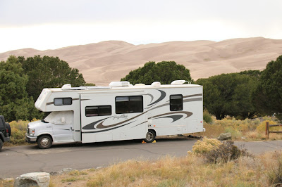 |
The campsite with the dunes in the background
|
We do usual routine, to the visitors center, look at the exhibits and then watch the movie. We then take the 1/2 mile nature loop trail from the visitors center with great views of the Sand Dunes and the Sangre de Cristo Mountains. These sand dunes are the highest in North America at 755 feet. This park has several good trails in and out of the Sand Dunes. The campground is at 8,200 foot elevation and the highest point in the park is Tijeras Peak at 13,604 feet. The views are spectacular with the grassland in the foreground with the huge sand dunes and the mountains in the background.
 |
The Dunes are stunning as you ride into the Park in late afternoon
|
At 7:30 AM it’s 23 degrees outside and 37 degrees inside the RV. After warming up, we take a ride on the Medano Pass primitive road to the “Point of no Return” where there is a trailhead for the Sand Ramp Trail. The Point of no return is the turn around place to normal 2 wheel drive vehicles, only high clearance 4 wheel drive vehicles are permitted beyond this point. The trail is about 2 miles long, very sandy, with considerable up and down. It travels from prairie into a juniper and piñon forested area with great views of the sand dunes and mountains. The Rabbitbush is in bloom and the other grasses are particularly colorful at this time.
 |
Great mountain views from the trail
|
 |
We passed a herd of Deer
|
 |
Beautiful Trail
|
 |
A narrow path to traverse the dune
|
 |
| Twinkles on the trail |
Afterwards we took a ride to the nearby town of Mosca which doesn’t have much of note except a small general store. We then drove to the town of Alamosa on the Rio Grande River. It has a very nice old historic downtown with many great old buildings. We went into the Narrow Gauge Newsstand which we were most impressed with. Alamosa was once a major rail hub and remains a vibrant railroad town with the Rio Grande Scenic Railroad excursion trains.
 |
Beautiful old Masonic Hall in Alamosa
|
 |
I took a liking tot he Purple Pig Pub
|
 |
Alamosa street scene
|
 |
| Old Illinois Central Car at the rail yard |
The campground fills up on Friday with the weekend crowd and the big thing here is sliding on sled or sand boards down the dunes. Also hiking to the top of the highest dune, High Dune, is a big deal. We found that the dunes in the heavily traveled ares are very loose and hard to walk especially when going uphill. Twinkles was not going to do the “top of the dunes” hike, I was thinking I might do it, it can’t be that bad. It was very crowded and I was behind a boy scout troop for a while, some of the kids were whining and the leaders were not very fit looking, I easily could have passed them. I didn’t have any water or food, it was still a long way to the top and choose to turn around a save it for another day. The views in the dune field were incredible.
 |
Lots of people out with sleds and boards
|
 |
Downhill on a sled
|
 |
Lots of green and golden vegetation
|
 |
That darker hard packed stuff was nice to walk on
|
 |
Walking down in a valley with a person sliding down the
slope on the left
|
On our return to the campground, Twinkles goes off on another short hike while I take the Dunes Trail. The Dunes Trail takes you to the Medano Creek where you can cross over to the Dunes. The Creek flow is low this time of year and goes underground allowing you to walk across without getting wet in places. I crossed over and walked up into the dunes for a while and then returned. The skies were cloudy and stormy looking, but nothing materialized from it.
This area has also been a crossroads for many cultures, the American Indians, the Spanish, the Mexicans and finally the Americans. The Sand Dunes area remains to this day a sacred area to several of the Indian tribes. There was also much conflict between the big cattle ranchers and the Mexican sheep herders with the cattle ranchers coming out on top.
The Nature Conservancy, one of the greatest organizations on the planet, bought the 100,000 acre Medano and Zapata ranches in 1999 to protect this land adjacent to the National Park from development. This in conjunction with the National Park’s acquisition of the 100.000 acre Baca Ranch and expansion of the Park now protects the San Luis Valleys water aquifer and the Great Sand Dunes National park.
Last but not least, great sunsets.
 |
| Sunset over the dunes |
Next stop is Questa, New Mexico,
Twinkles and Slick


No comments:
Post a Comment