May 22 - 28, 2018:
It’s was an 80 mile mountainous ride on route 160 and route 140 through parts of the Ute Indian Reservation. On entering New Mexico it becomes route 170 and the road becomes a much rougher surface passing through part of the Navajo Reservation. It is poor looking country with increasing oil and gas well development. Driving into Farmington, New Mexico from the north, the city is not very hospitable looking, mostly trashy looking oil and gas industry businesses. The economy here is driven by oil and gas, it’s been somewhat of a boom town, but it’s not pretty. The city is mostly strip malls, chain stores, malls and associated service industries. Tourism also accounts for a part of the economy with several Indian Pueblo attractions in this area of New Mexico.
We have made reservations for a week at the Bluff View RV Park in Farmington, the bluff really is impressive, but it's a distant one seen between cars on the busy road. It’s a small, tight campground with full hookup sites, good WiFI and convenient to shopping. Also right next to a 7-2-11 store and the best laundromat we have ever used. If we were doing an RV park review, we would probably complain about the traffic noise, but it’s not a big deal.
The election for sheriff seems to be a huge deal here, there are lots of roadside campaign signs and as we go to the visitors center there are many people coming in for early voting. This election seems to be a politically charged one, is the sheriff postion that big a deal ?
The museum inside the visitors center was an interesting one with an exhibit on the Navajo Trading Posts and a special exhibit on impressive dinosaurs finds in New Mexico.
 |
| A beautifully restored oil delivery wagon |
 |
| Along with a oil tank hand cart |
 |
Will Evans managed a Trading Post and became a noted
Navajo sand painting artist |
 |
| Typical Trading post supplies |
 |
| Something old and smelly having to do with oil wells |
We originally wanted to go straight into Chaco Culture National Historic Park about 50 miles south. There is a campground there, but when researching it we found that to get into this park you must drive about 14 miles on a rough dirt road surface that is not very RV friendly. It is also a very remote area with no services or nearby towns or campgrounds. Instead, we decided to camp in Farmington and drive in for a day. You would think that someone could make money with a campground near the highway ! Chaco Canyon is regarded as having one of the best, if not the best, Ancestral Pueblo Ruins in the country. I almost think they may be keeping the road rough intentionally to keep hordes of people away, actually that would be smart.
We travel a few miles to the Salmon Ruins which were built by the Ancestral Puebloens in 1090 AD. The architecture and artifacts show a relationship to those in Chaco Canyon about 50 miles south of Farmington. The pueblos were inhabited until about 1280 when the people moved away from this region. This property was homesteaded by a pioneer named Peter Salmon in 1877 who protected the ruins from pot hunters. His heirs eventually sold the property to the San Juan County Museum Association in1969. The site was excavated and stabilized between 1972 and 1978. Artifacts found in the ruins are exhibited in the on site museum.
 |
| This is the original bunk house from the Salmon ranch |
 |
| The walls of the ruins are in remarkable condition |
 |
The Aztec Theater has a great sign
|
 |
| I remembered this mural from years ago and admired it again |
 |
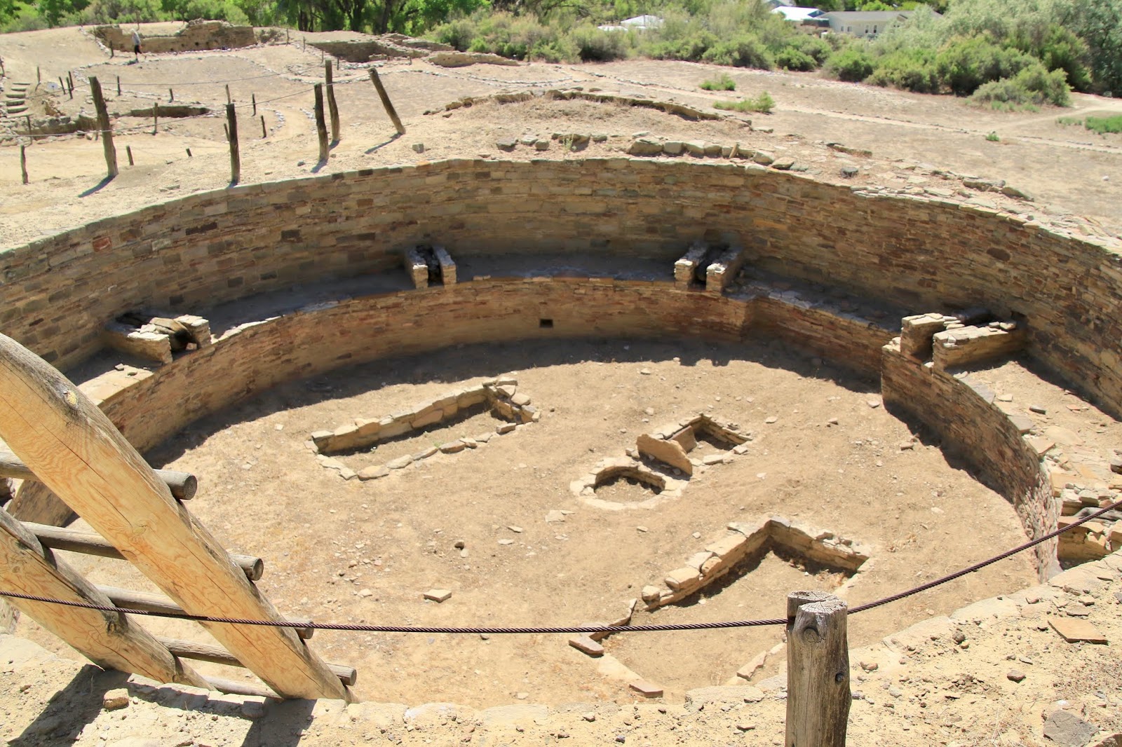
| The great Kiva is huge and very impresssive |
 |
It is believed that this Pueblo and others in the area
were all influenced by the Chaco culture 50 miles south
|
 |
Much of the wooden beams have been dated by a process
where they remove a core for testing. This wood was from 1284
|
 |
This is the original roof from the late 1200's
|
 |
Twinkles peeking through a narrow doorway
|
 |
They incorporated a green line of rocks on the outer wall
|
 |
| Aztec Pueblo has about 400 rooms |
We couldn’t come here and not visit the Chaco Canyon National Historical Park which is also a designated World Heritage Site. The much discussed rough dirt road into the park really wasn’t as terrible as expected, the last 4 miles are a very corduroy surface, but we have been on far worse. It would have shaken the RV pretty good, but we could have done it, but actually I’m glad we didn’t.
The centerpiece of the Chaco ruins is Pueblo Bonito, considered the center of the Chacoan world. It was built in stages and occupied from the mid 800’s to the mid 1200’s AD. It eventually towered 4 stories high with over 400 rooms and over 40 kivas. It was a windy day and Twinkles had a mishap when her beloved Tilley hat blew off and landed down in the bottom of a Kiva with no way to retrieve it. On leaving the Park, we made a stop at the visitors center so Twinkles could report her lost hat. I figured they would just laugh but instead they said it happens often and they would retrieve it and send it to her.
 |
This is Fajada Butte which has a petroglyph on top called the Sun Dagger
that aligns with the sun during the summer and winter solstice |
 |
Fine masonry work and original 1200's wooden beam, these
wooden beams were not native to the area, had to be carried
from many miles away
|
 |
| An interesting eroded rock |
 |
This shows the thickness of the walls
|
 |
| View of one section of the ruins |
 |
This is a Great Kiva, there are 3 of them and about 35
smaller ones just in the Pueblo Bonito compound. Kivas
were used for ceremonial events and are all very similar in build
|
 |
A massive rock column known as threatening rock adjacent
to Pueblo Bonito fell in 1941 damaging a number of rooms
|
 |
Some of these walls were huge, needing a little support
after 800 + years |
 |
Three or four stories tall all done by hand, no cranes, no
power tools ! |
 |
The ruins go on and on, there are about 400 rooms, it seems
that everything you read gives a different number |
We did a two mile loop trail, the Pueblo Bonita Overlook Trail, which goes to an overlook above Pueblo Bonito. The initial rocky up canyon section of the trail was rough, but once on top the trail was mostly flat. At this point on the trail we are looking down on Kin Kletso Pueblo. There are many large Pueblos here in addition to Pueblo Bonito. The overlook views of the both Pueblos from the trail were worth it, although Twinkles disagreed.
 |
Twinkles was wondering why she climbed up here
at this point and how to get down
|
 |
| Looking down onto Kin Kletso Pueblo far below |
 |
Pueblo Bonita from the overlook looks small
|
 |
This view gives more of a three dimensional feel to it
|
 |
This is another huge rock that looks like it may fall
on the ruins some day |
The big event in Farmington for the Memorial day weekend is the Riverfest, a three day event along the Animas River from Berg Park to Animas Park. The River Walk is about a mile with food and entertainment at each end and at a few smaller areas in between. It can’t say we were overwhelmed with the festivities, but it was entertaining to people watch.
 |
| A farm exhibit in the park |
 |
This hit or miss engine powered dish washer
was entertaining |
 |
Fair food is the same wherever you where
|
 |
| Twinkles getting some Navajo fry bread |
 |
| The Animas River is a nice fast flowing stream |
Farmington, NM is surrounded on three sides by Navajo and Ute tribal land, which makes up about 25% of the population. It seems to me that about another quarter is part Indian. Farmington is in a beautiful green valley setting which was once a major farming area, hence the name Farmington. The fertile valley results from three rivers, the San Juan, the Animas and the LaPlata that run through it. There are still farms and ranches here, but in the 1950’s oil exploration came to town and pretty much took over resulting in wild unrestricted growth. It continues today, half the businesses in town seem to be oil and gas field related, but it’s been in a slump for the last decade loosing 8% of its total population.
https://en.wikipedia.org/wiki/Farmington,_New_Mexico
It took me a couple of days to find the actual old downtown with a few interesting stores, old buildings, antiques shops, Indian arts and crafts stores and a vibrant brewery / restaurant. The city is trying to revive this area, but it doesn’t appear too successful. The Three Rivers Brewery (3RB) rules the 100 block of East Main Street with the 3RB Restaurant, the 3RB Brewery, the 3RB Pizzeria, the 3RB Distillery and the 3RB Tap Room all in a row. They have done a good job restoring these early 1900’s buildings. There are also two classic movie theaters on Main Street in Farmington, the Totah built in 1948 with an Indian motif and the Allen Theater built in 1920’s. The Allen is no longer a theater, but the Totah is used periodically for theater production and is available to rent for special events.
 |
| Unusual round rock "bombs" in the sandstone |
 |
| A geologic wonderland of rock here |
 |
| Many coal seems were visible, don't tell |
 |
| Lots of Hoodoo's |
 |
This was a favorite formation of mine
|
 |
Unusual erosion is everywhere
|
 |
| Lots of colorful geology here |
It’s been kind of nice to be able to walk around the corner to the 7 / 2 /11 store (not to be confused with a 7-11) store, I’ll miss it, but not the road noise at this campsite.
It will be far different at our next stop at Cochiti Lake Recreation Area, New Mexico,
Twinkles and Slick


No comments:
Post a Comment