Barstow to Mammoth Lakes, California:
June 7 -13, 2022
I’m now heading on route 40 west towards Mojave, California making an unplanned stop at the Borax Mine and Welcome Center. Borax is now known as U.S. Borax, part of Rio Tinto who is the global leader in the supply and science of borates worldwide.. It turns out to be way better than imagined, (love it when that happens) housed in a modern building on a massive hill top that is actually all the earth removed from the colossal Borax open pit mine. This is the second largest borax mine in the world. They have great exhibits and a gift shop showing old classic Death Valley Days movies and I even got a free sample rock from an outside rock pile.
https://en.wikipedia.org/wiki/Borax
 |
| It's just huge ! |
 |
| Death Valley Days a true classic |
 |
| Genius promotion |
Continuing on to Mojave, the quantity of windmills, or I should say Wind Turbines is astounding. I wanted to get a photo to illustrate this but there is no place in town to get a clear shot so I take a ride to search for a better angle. I eventually find a road outside of town that gets you near the action. There really is not much to do in downtown Mojave, it is rather depressed looking. The big deal is the Space Port but there seems to be nothing open to the public except a once a month Saturday event.
https://en.wikipedia.org/wiki/Mojave,_California
 |
| Interesting view but not what I wanted |
 |
| That's what I was looking for |
 |
| Great mural on downtown side street |
I see no reason to stay in Mojave and there are a few BLM dispersed camping areas north on route 14 that I may want to overnight in. Red Rock State Park comes up first, but it is a pay site and Twinkles and I had camped there for a few days many years ago. I may return, but first I want to check out this BLM OHV area a few miles north. The BLM area is open and there is even a BLM road map in the box at the entrance (those boxes are usually empty). These areas can be very confusing, this as an OHV area and there are many, many roads / trails and you can get very lost quite easily. There is absolutely no one here, I take the main smooth dirt road to see where it takes me. No one is out here, I could simply pull over anywhere, but I keep going and going to see the area. I finally come to an area with a good view and it will be my home for the night. I take a walk around, the Joshua trees are impressive as are the Creosote bushes which look especially healthy. I’m on the lookout for snakes, but see none, but do see a couple of huge jackrabbits. As night comes, It’s definitely a dark sky area and no one is here, also no noise, a little spooky if so inclined.
 |
| Probably hundreds of miles like this out here |
 |
| That's my favored site |
 |
| The Joshua Trees are not plentiful but are stand out |
In the morning I head out at 8 AM before it gets too hot and return to Red Rocks State Park where I take this amazingly scenic nature walk trail for an hour or so. This area is incredible, the views and colors of the rocks are amazing and the morning light is great.
 |
| Views like this almost from the parking lot |
 |
| A closer view |
 |
| Another view |
 |
| This formation in front is called Turk's Cap |
It’s then back on routes 14 / 395 north. I make a short stop at another very photogenic volcanic cinder cone area close to the highway. I am taken by the great contrast with the black cinder cone to the almost white mountain range in the opposite direction.
 |
| Much volcanic action around here |
 |
| Opposite direction |
I always love to stop at historic road signs and this one set me off on another adventure. The sign told of a nearby charcoal oven with an amazing story. This prompts me to drive to the remains of the ovens a mile away down the sandy road. The story goes that in order to get lumber for the mines, they cut trees up in the mountains, floated them down a water sluice to the ovens, then they were transported by rail and boat and ultimately to the mine ? Sadly the protective roof to shelter the ovens has blown off and they are now slowly melting away. Nearby, I see bridge remnants of the old rail line that came through with some interesting graffiti or street art as I prefer to call it.
 |
| The original charcoal ovens |
 |
| Nice shot of the van and remains of a railroad bridge |
 |
| Art work on another rail bridge |
I arrive at my destination, Lone Pine, California at noon, park and walk around the main street and visit a small museum with a large bug exhibit. The woman docent was very pleasant and recommended to me a couple of places to visit, one being the Whitney Portal Road that takes you to the Mt. Whitney trailhead. The road to the Mt. Whitney trailhead is itself quite a thrill ride, going very steeply uphill for miles into the lush cool mountain air shaded by huge pine trees. The have a campground (now closed due to a rock slide) and a small store / cafe mostly for the through trail hikers. As Mt. Witney is the highest peak in California, this hike is on everyones bucket list. The hike to the summit however is a 22 mile round trip gaining 6,100 feet in altitude, a two day hike for most people and requirs a permit. I’m now thinking how much altitude gain that is per mile, maybe the hike is not as killer as it sounds, but it’s a 14,505 foot elevation, that matters.
https://en.wikipedia.org/wiki/Lone_Pine,_California
 |
| Downtown shop with interesting sign |
 |
| Those sporting goods signs are true classics |
 |
| So is this Merry Go Round sign |
 |
| A fishing Hardware sign |
 |
| A view from the Mt. Whitney trailhead parking lot |
 |
| Huge boulder that smashed down into the campground |
 |
| Nice waterfall |
After coming back down, I go into the BLM Alabama Hills area just outside of Lone Pine that is famous as a location for hundreds of old western movies. The rocky landscape is incredible with the backdrop of Mt. Whitney which still has pockets of snow remaining. This area is all free dispersed camping and it’s simply the best. I found a spot easily, it’s not crazy crowded this time of year due to the heat. They are taking step to protect the landscape by closing off areas for restoration. I hope this works, if not I could see more restrictions to restrict camping out here. Not all, but some campers are slobs, they leave garbage behind, trample the vegetation, spew the remains of their campfires all over. I spend two nights van camping in the Alabama Hills at different sites and do a couple of short hikes, the terrain is out of this world.
 |
| All Holliwood hero's of the old west |
 |
| Hopalong Cassidy |
 |
| Pretty sure i had one of these |
 |
| The Lone Ranger |
 |
| Mobius Arch with Mt. Whitney in the background |
 |
| Just a common view in the Alabama Hills |
 |
| Another iconic sight |
 |
| Another |
 |
| It goes on and on |
 |
| Interesting cave formations |
 |
| I'm lost in the amidst the rocks ! |
In downtown Lone Pine I see many hikers who are doing the Pacific Crest Trail and other lengthy trails that come through here. Most look kind of beat and ragged, like they should, but others I wonder about as they look too prim and proper with their very pricey backpacking gear. I kind of wonder how much of the trail they really do or is it a fashion statement.
After getting my fill of Lone Pine, I head north on route 395 for Bishop, California. It’s beautiful scenery all the way, the eastern Sierra Mountain slopes are spectacular. In Bishop, I do my usual ride through the downtown then park and walk to the central downtown area. I stop at a bakery and get a great “cowgirl” cookie, take a few photos, then go into an outdoor shop looking for a good sun protecting long sleeve shirt. Surprisingly, I find exactly what I need and buy it even though it is probably the most expensive shirt I have ever bought. It’s then back to the roasting hot van, then to drive around for a while aimlessly just to cool down. I do find a shaded park area for shelter for a while and there is a slight breeze blowing. I could use a nap but it’s too hot in the van unless you are somewhere where all the doors can be opened. Such are the perils of van camping.
https://en.wikipedia.org/wiki/Bishop,_California
I consider my alternatives for the overnight and for convenance sake settle for a dark quiet back street in the downtown area which works very well.
It’s Sunday morning so I treat myself to a great breakfast at Jack’s Restaurant and Bakery, my first real breakfast on this trip. I then head back south to Big Pine and take route 168 to the White Mountain Road which takes me to the Ancient Bristlecone Pine Forest. This drive is about 23 miles all uphill to a 10,000 foot elevation with plenty of curves, straight down drop-offs in places (no guard rails) with incredible views of the distant Sierra Mountain range. This is the place where the amazing longevity of these trees was first discovered. Bristlecone Pines are now known as the oldest living trees on Earth at 4,000 + years old. It was very windy day and the coolness of the air at the 10,000 foot elevation felt wonderful.
https://en.wikipedia.org/wiki/Ancient_Bristlecone_Pine_Forest
 |
| View from the trail |
 |
| The ancient dead ones become bleached to wonderful colors |
 |
| Many of the ancient ones still are alive |
 |
| This is truly a wilderness area |
 |
| A particularly attractive tree |
Back in Bishop, I make a stop at the remarkable Eric Schat's Bakery which is about as good as they get. It may be the most popular tourist stop in Bishop ? The sandwich line at lunch is huge, I couldn't wait that long for a sandwich.
I then ride out of town about 5 miles, turn off into the desert eventually getting on the Casa Diablo Road to the BLM Volcanic Tablelands BLM free camping area. Internet research opened up interesting facts about the Casa Diablo Road which leads to the Casa Diablo Mine (House of the Devil Mine). The campsite sits directly on the edge of one of the volcanic rock table outcroppings. There are bands of these harder rocky table outcroppings with more eroded sandy areas in between.
 |
| A view near my campsite |
There are several creeks which run out of the mountains into the Bishop area, but at all of them you see signs indicating that this is the property of the City of Los Angeles and there is to be no trespassing. I thought this to be odd until I learned the story. In the early days of Los Angeles as the city was growing fast, at some point the city leaders determined that the water supply was inadequate. As a result they methodically started to buy up as much land with water rights as they could in this area of California. They then built aqueducts to transport the water to Los Angeles. The local residents did not really understand what was happening until it was too late, their water rights were gone. There has been some form of agreement recently to rectify issue somewhat.
 |
| One of several waterways near Bishop |
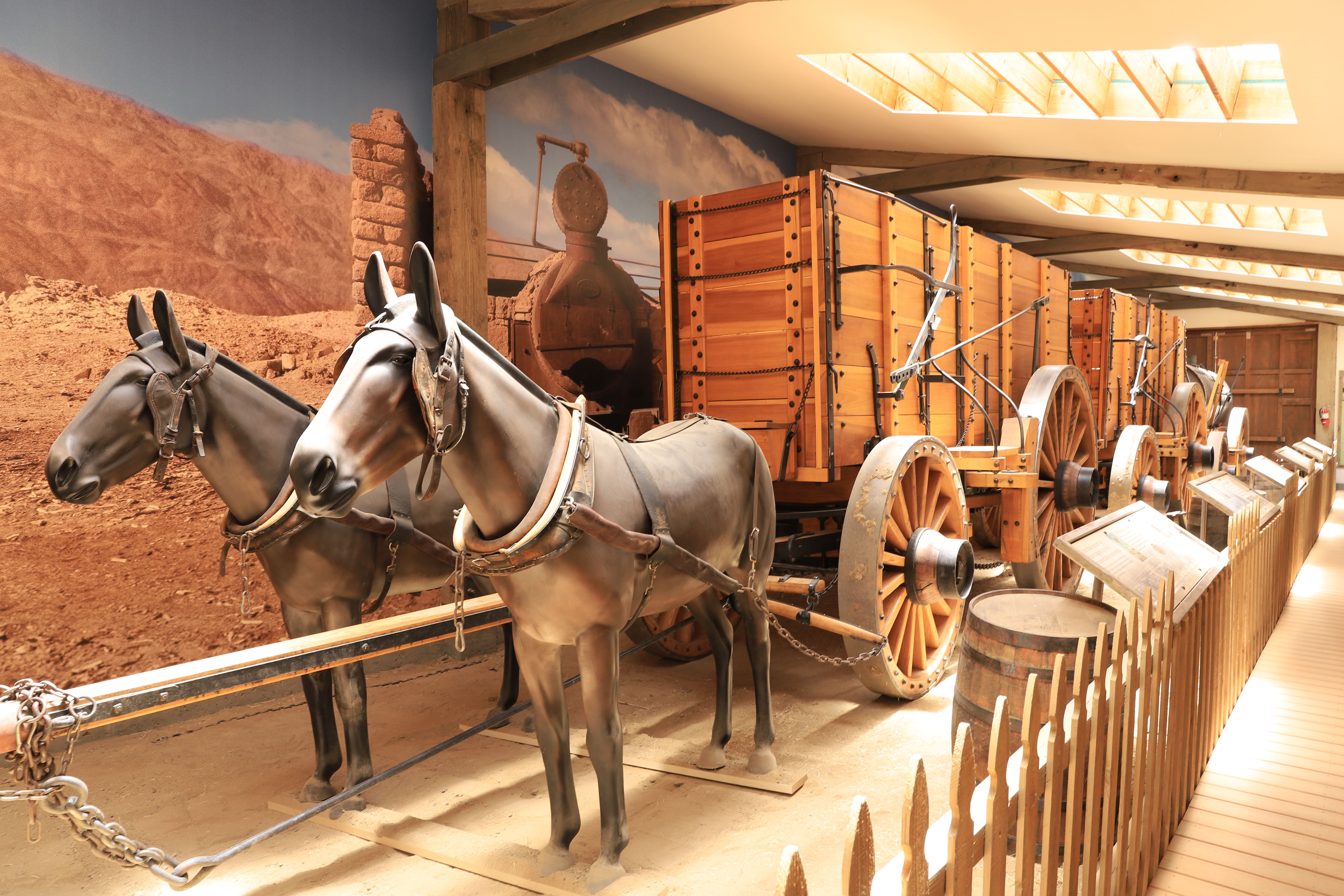
I also went to the Laws Railroad Museum which is way more than Railroad Museum, actually it’s an everything historical museum. I’ve been here before, but years ago and things do change. Actually there is one totally new exhibit that recently opened on Mules, those animals that don’t get as much respect as they should, they were instrumental in the development of the west. They were often utilized instead of horses as they ate less, could carry heavier loads, have better stamina and are equally smart. They now have a Mule Museum exhibit building that houses two reproduction Borax ore wagons that have taken part recently in parades at the US Capital and the Rose Bowl Parade. They also have great information on Mules, I never knew they were so highly regarded and special. Of course, it was mules who pulled the famous Borax Wagons back in the day. It’s ironic to run into this as I was just at the Borax Mine and visitors center in a week ago.
 |
| The Mull exhibit featuring mules and reproduction Borax ore wagons |
 |
| Close up view of a wagon built exactly to original drawing |
 |
| A Donkey and a Horse are a good mix |
 |
| That's a great recommendation |
 |
Another
|
 |
| An old Balwin Steam Engine |
 |
| The old train depot |
I decided today, it’s a good time for me to get a cheap motel for the night, except there are no cheap motels around here, when did Motel 6 become $120 a night ? No, I didn’t go to Motel 6, I found a slightly cheaper one. Capitalism is raging here, as it is everywhere as businesses and corporations have raised their prices to compensate for their loses during the pandemic.
I visit the Paiute-Shoshone Cultural Center in the morning with good exhibits on tribal history, an art gallery, a gift shop and a display of tribal members who served in the US military. They have lived in this area forever and are yet another sad testament in United Sates history. Their land was taken from them by force and they were forced to move elsewhere. Somehow, they have survived and now have tribal recognition and a small reservation in Bishop. They also have a small casino operation and a thriving convenience store and gas station. They have the cheapest gas price in the area and are now doing a booming business at the pumps.
https://en.wikipedia.org/wiki/Bishop_Paiute_Tribe
Next stop is Mammoth Lakes, California


No comments:
Post a Comment