April 26 - 29, 2018:
Our travel path today was uphill on routes 319 crossing into Utah where it became route 56 and continued to climb through barren creosote and sagebrush scrub country. I made a short stop in a semi-ghost town of Modena and then continued on to Cedar City where we took route 15 north to route 20. There were a couple of long uphill ascents on both routes 15 and 20 with distant views of snow capped peaks. After a long climb on route 20 we descended to route 89 and our destination in Panguitch, Utah.
 |
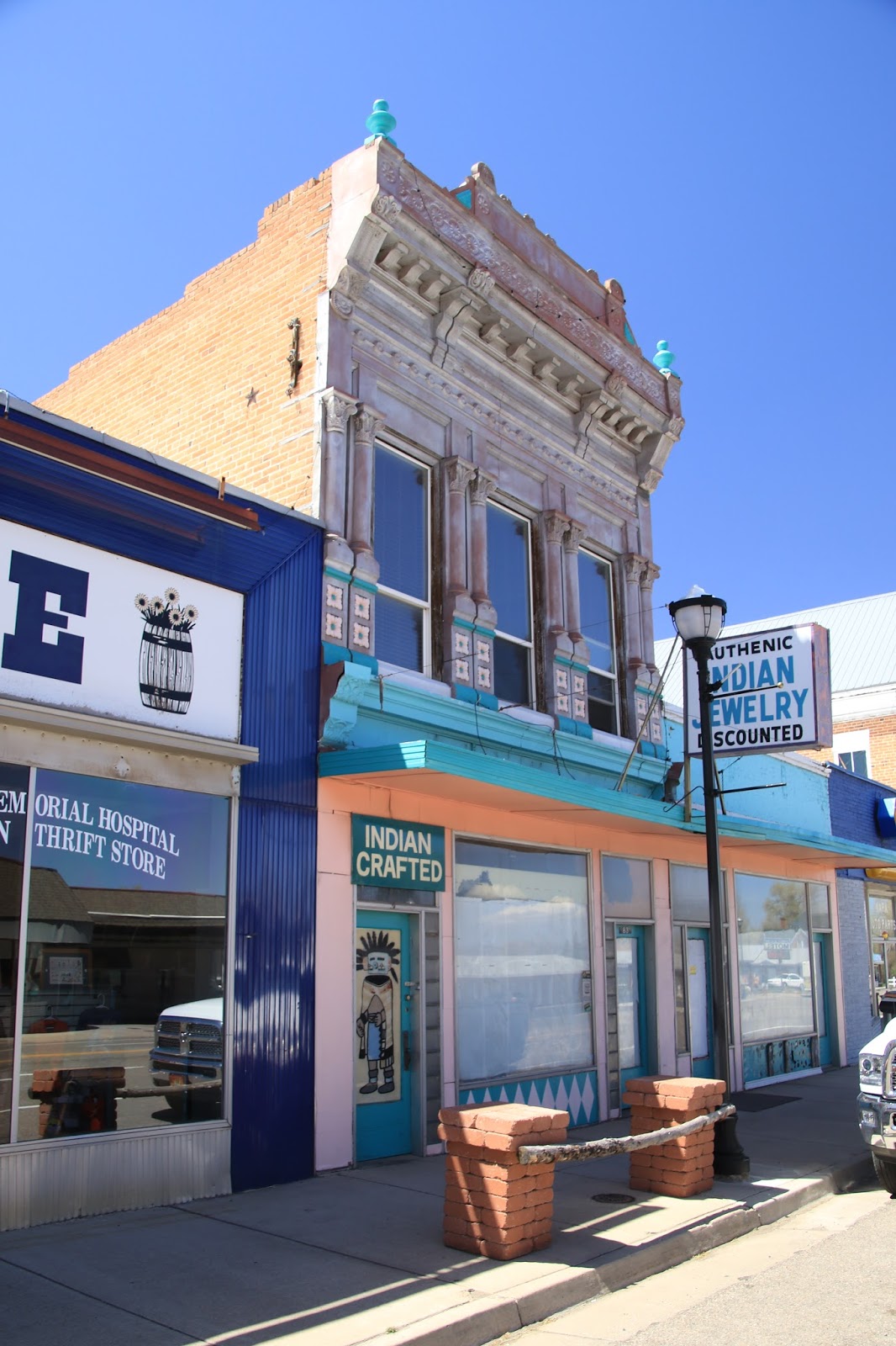
The old store in Modena hints at prosperity in past days
and still a railroad town
|
We have been in Panguitch before, May 2014, it’s a historic Mormon townsite, neat and clean with easy access to Bryce National Park and Cedar Breaks National Monument. We thought about going to the campground inside Bryce National Park but it is still in the freezing zone at night with no electrical hookup. After a week of dry camping, we decided it was time for some creature comforts and the proximity to shopping and restaurants in Panguitch. As result, we made a reservation at the Hitch-n-Post RV Park in Panguitch for a full hookup campsite. The WiFi and facilities were excellent, but beware, most everything in Panguitch is closed on Sunday, except the gas stations and convenience stores. Can you tell, I was really looking forward to a good Sunday breakfast ?
 |
| The campground is folksy |
 |
| Downtown Panguitch |
 |
| The old Indian shop now appears to be closed |
 |
| Smokehouse Cafe, I still haven't eaten there ? |
I had hoped to visit Cedar Breaks National Monument from here as we have not been there yet. On checking I find that it does not open until mid May due to its 10,000 + altitude, I'll have to save it for another time.
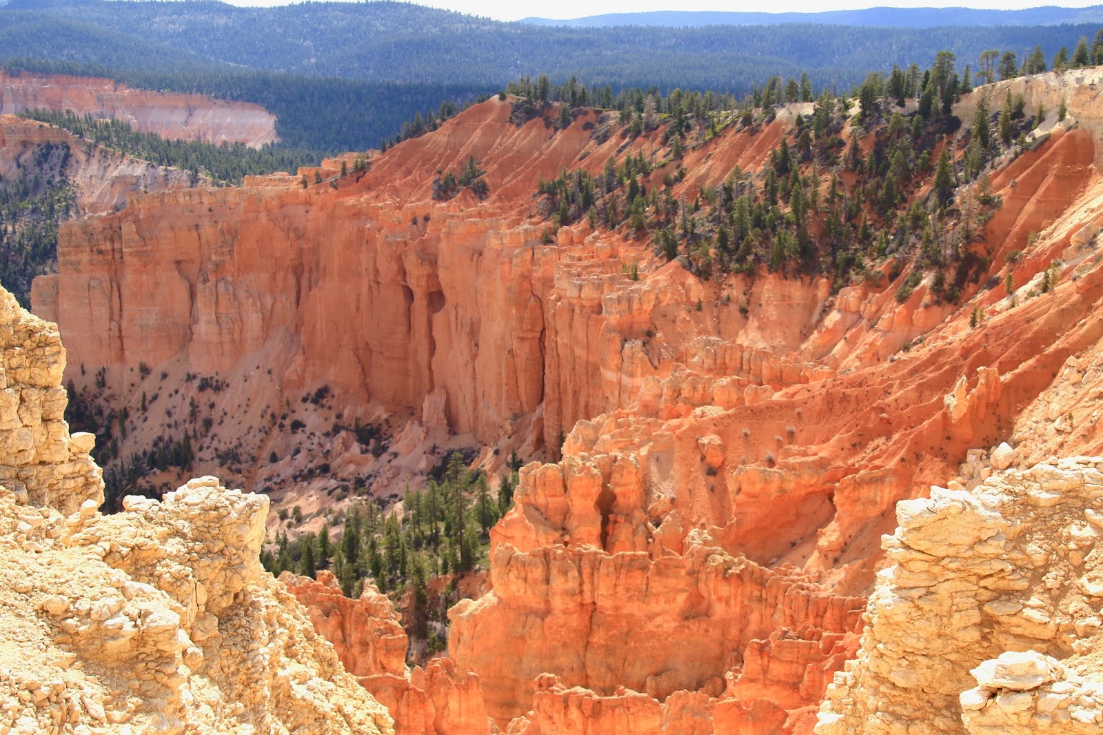
This is a decent time to visit Bryce National Park, its not too awful crowded yet, but there is a large number of Asians and Europeans here already. We did the usual gawking in amazement thing looking down into Bryce Canyon from Sunset Point and the Rim Trail. We then took a deep breath and started down the steep Navajo Trail for 600 feet and 36 switchbacks into the canyon. At the intersection, we took the Queens Garden Trail which meanders around the scenic hoodoos and pinnacles in the canyon and then climbs back up to Sunrise Point and the Rim Trail. The uphill on the Queens Garden Trail is not as brutal as going back up the Navajo Trail and we were okay with that. This trail loop was beautiful, it doesn’t get much better ! Afterwards, we went to the Bryce Canyon Lodge for a hearty lunch. This is another one of those classic National Park Lodges that you just must visit.
 |
| The view down into Bryce from the rim |
 |
| We are now making our way down |
 |
| Great views in all directions |
 |
| No end to the Hoodoos and spires |
 |
All the switchbacks are interesting
|
 |
As are the rock monuments
|
 |
| View from the rim at Sun Rise Point |
 |
| We had a great lunch in the Bryce Canyon lodge |
We then drove out to the end of the park to the Rainbow Point parking area and hiked the short Bristlecone Loop Trail.
 |
| A view from the trail |
As you travel to Bryce you pass through the Red Canyon area of Dixie National Forest which is like a smaller version of Bryce Canyon with many good trails, don’t miss it. We hiked a loop trail there with impressive views from the visitors center and then drove a few miles away to hike the the Arch Trail.
 |
The Red Canyon area is similar to Bryce except you don't have to walk 800 feet down
and it's far less crowded |
 |
The trail cuts across a steep slippery slopes in places
|
 |
| Great views are common |
 |
Unusual rock formations are the norm
|
 |
| A series of small arches like a sculpture garden |
The most popular and crowded hikes at Bryce Canyon are the Navajo LoopTrail, the Queens Garden Loop Trail and the Peekaboo Loop Trail. There are many other trails that aren’t as spectacular, but are more remote, serene and peaceful. So, to get some of that vibe we set off down the Swamp Canyon Connector Trail to the Swamp Canyon Trail and then uphill on the Whiteman Connecting Trail. These trails were mostly in the wilderness area of the park and we passed only three people on this entire hike. This area of the park has burned sometime in the past decade, sadly killing many of the Ponderosa Pine trees, but it was interesting to see how the forest is recovering. The open areas are covered with Manzanita now, there new groves of Aspen in places and many new pine trees. The only drawback with this hike is that once back on the Canyon Rim, we had to walk along the roadway for a few miles back to the Jeep.
 |
| Heading downhill into the canyon |
 |
| Massive rock fortress ahead |
 |
The area burned several years ago, but its still interesting
|
 |
| The trail passes this wild viewpoint |
 |
| With a deep drop-off at trails edge |
 |
| The trail is really on the edge, don't slip ! |
 |
| Heading back uphill to the rim |
On the way out of the park we stopped at Inspiration Point where the crowds were somewhat crazy, I think a tour bus had just pulled up, (did I say earlier that the crowds weren’t so bad ?), but it is the weekend. It was then to the visitors center to look around and visit the gift shop, it was mobbed with tourists, everyone needs a souvinir and I have to say the Park Service has much to offer.
 |
| The amazing view from Inspiration Point |
 |
| Zooming in for a closer look at this arch |
Our next stop is Escalante, Utah,
Twinkles and Slick


No comments:
Post a Comment