September 6 - 8, 2010: Lander to Rock Springs and Green River, Wyoming
I leave Lander, Wyoming in the morning after visiting Sinks Canyon State Park and then head south on routes 287 and 28 which climb steeply with great views of the Red Canyon geology. My plan was a quick stop to see the semi-ghost town of Atlantic City, Wyoming, no comparison to Atlantic City, New Jersey. Also close by is the ghost town of South Pass City. Atlantic City is located about 4 miles off the highway taking decent gravel roads. They have a well done historical walking tour map which I follow partially. There really wasn’t much to get excited about in Atlantic City, it’s very rustic, but mostly uninteresting dwellings that are still inhabited. The town population is about 50 people according to the internet.
https://en.wikipedia.org/wiki/Atlantic_City,_Wyoming
As it’s lunch time and the Miner's Grubstake is open, even though I’m not very hungry, I feel I need to go in just to see it. The interior has been redone with the usual western motif, many dead animals, guns, a little biker touch, but no one looks very cowboy here. There were two guys at the bar, recent transplants, one from New Jersey, who asked the owner about the place. It turns out the owners came from California, bought the business, fixed it up and opened about 8 years ago. They took a restaurant management class at the university because they had no former experience in this field. She works the front-end and he works the kitchen. The food was good, but I think they missed the part in their training class about customer service as it was painfully slow. I can have the best meal in the world, but I can't tolerate having to wait and being ignored for 10-15 minutes to get the check and to pay.
 |
| Barely surviving the Bust |
 |
| Atlantic City Mercantile was closed |
 |
| Thank you St. Andrew's |
 |
Walking tour stop # 7
|
 |
| Inside the Miners Grubstake |
I then did a road tour looking for the other ghost town of South Pass. I came upon an abandoned mining site with several buildings which I believe to be South Pass, but the only signage was "Private property- KEEP OUT", so I really don't know. This area had a lot of mining activity for a brief period.
 |
| Several mining buildings remain |
 |
| Could still be limited mining here ? |
I had picked up a map earlier in Lander which showed a road called the Red Canyon Drive with great scenic views and dispersed camping off route 28 in the Atlantic City area. I found this map very confusing as the unpaved road off route 28, officially Forest Road 300, but is called the Loop Drive, not the Red Canyon Drive. Trying to solve this mystery, I drove back to Lander and found a Red Canyon Road which seemed correct, it had great scenic views, except that there were no signs on the road and it ended at an old ranch. This area on subsequent investigation has areas under Nature Conservancy protection and there is a NOLS campus area located there.
 |
| Lush green valley |
 |
| The photo is straight, the old house is really leaning |
 |
| Scenic red rock landscape here |
I end up driving back on route 28 to the Forest road 300 (Loop Drive) and found an easy access dispersed camp site for the night.
 |
| It's a roomy campsite |
In the morning, I drive further on the Loop Drive and find several more large open dispersed camping areas and hundreds of campers. The road initially is out in the open, but then as you travel goes in and out of the forest. I drove about 8 miles on the road to Louis Lake and then turned around. Louis Lake is a large lake with a cabin rental and camping area, a ranger station, a boat dock, fishing access and picnic areas. Be advised, It is a narrow gravel road and some of the locals drive their ATV’s a and pickup trucks like “Mad Max”. I ingested plenty of dust, should have worn a mask. If you stay on this road you will eventually get to Lander according to the road signs, but it’s a long dusty rough ride.
 |
| A roadside view |
 |
| Louis Lake is beautiful |
Getting back on route 28, I head south where the terrain is wide open prairie country with many “places of historical interest” signs which I rarely pass. They are mostly dealing with the Continental Divide which we are crossing, the Oregon Trail that came through here, the optional Lander cutoff Trail, the Pony ExpressTrail and the South Pass Trail used by the earlier Mountain Men and the Indians to cross the Rocky Mountains. Oh, and don’t forget the Mormon Trail which also came through here. This was truly a major crossroads during the years of western expansion.
 |
The South Pass (Indians Trail) was eventually used by mountain men and trappers to
pass over the continental divide |
 |
| A decision was made here, to take the shorter Lander cut-off or stay on the main Oregon Trail |
 |
Another decision here; stay right for the shorter but higher risk Sublette cutoff or stay left
for the main Oregon, California and Mormon trails |
 |
| The "Parting of the Ways" monument |
 |
| The Oregon Trail can still be travelled today on foot, horse or bike |
 |
| This was the interstate highway of its day |
I come to the town of Farson which is another major crossroads where the pioneer trails followed the “Big Sandy River”. Route 28 and 191 intersect here now where I take route 191 towards Rock Springs, Wyoming. Many travelers stop these days at a store on this intersection for a giant ice cream cone, there isn't much else these days.
 |
| The Big Sandy River isn't all that big but afforded drinking water and green grass for the cattle |
 |
| Parsons Mercantile, Home of the Big Cone |
This 40 mile road segment has one small town, Eden, and there is nothing but poor desolate rangeland as far as you can see. It is a windy day and as this road is high surrounded by miles of open land, the wind gusts are really strong. That explains the miles of double snow fences along the highway, the winter storms must be wicked here.
Rock Springs is one of the larger towns in Wyoming with a population of 23,036. Once there, it brings back memories, I’ve been here before. It’s Sunday so the streets and sidewalks are deserted, only a few poor looking bars are open. Wyoming has not stooped to the casino in every bar and convenance store level, I give them credit for that. I take away some credit though, since they are not mandating masks at all or doing much in the way of social distancing.
https://en.wikipedia.org/wiki/Rock_Springs,_Wyoming
 |
| A Rock Springs welcome sign near the railroad tracks |
 |
| It a very rare totally original 37 or 38 Plymouth 2 door sedan, very similar to my car |
 |
| A description of the Chinese massacre of 1885 |
 |
| A serious mural dealing with the infamous Chinese massacre in Rock Springs |
 |
| A downtown view |
 |
| Two historic buildings awaiting restoration |
 |
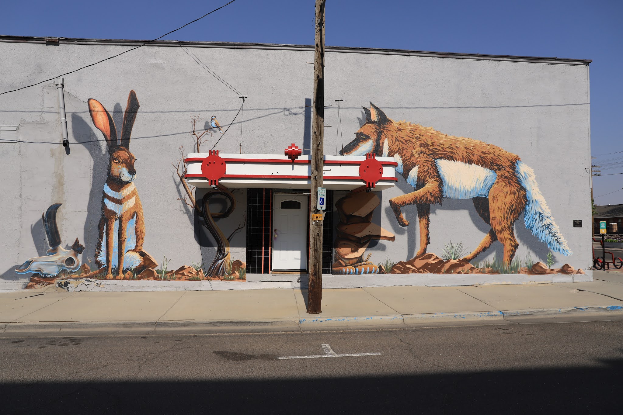
| Rock Springs entrance gate and mural |
 |
| Another great mural |
 |
| The former Rex Hotel and J. L. Newberry department store |
 |
| Interesting building facade |
 |
| Rock Springs pawn shop |
It’s another Railroad town and freight trains are regular and near the restored railroad depot is a sign telling how this is the site where the first coal was mined in Wyoming.
 |
| The Rock Springs train depot |
The weather forecast for September 7th through September 8 is a concern, it calls for a sudden drop to freezing temperatures along with wind and snow. I consider heading south to Utah to evade this storm, the sensible thing to do. No, I can’t do that, I’ll stick around to see the snow and ice, except I will do it from a motel room window.
On the morning of September 7th, before the storm, I'm thinking this forecast may be way off as it's a sunny and warm day. As a result, I go to the adjacent town of Green River to look around and soon realize I've been here previously. It has many points of interest in the downtown, a scenic railroad bridge over the tracks and an amazing historic old brewery.
https://en.wikipedia.org/wiki/Green_River,_Wyoming
 |
| This Brewery was a major one in it's time |
 |
| A beautiful mural depicting Horses and the Iron Horse across from the railroad yard |
 |
John Wesley Powell departed from Rock Springs on the Green River on his expedition
down the Grand Canyon |
 |
Love the hotel name
|
 |
This name is pretty good too
|
 |
| Trona was a common and valuable mineral that was mined here |
 |
| Still a major railroad operational center |
 |
| John Wesley Powell expedition departure point was about here |
 |
| John Wesley Powell expedition was incredible in every way |
https://en.wikipedia.org/wiki/Powell_Geographic_Expedition_of_1869
As the day progresses, it becomes windy and by evening the temperatures are dropping like a rock. Overnight the forecast becomes fairly accurate, the temperature is sub freezing, it's windy, cloudy and it begins to snow.
On the morning of the 8th, the Van is covered with with a few inches of snow, but not as much as expected. It is about 32 degrees, still windy and feels more like 20 degrees. The temperature remains near freezing all day. I brush some of the snow off, start the engine, drive the quarter mile to Walmart to get a couple of microwave meals (should have walked) and then back to the motel for the rest of the day.
 |
| Twinkles always calls it Snowflake, her name finally fits ? |
I enjoy being snowed in, it's like a day with no school ! I stay in and work mostly on my blog backlog, do laundry, watch TV, trip plan and enjoy the big warm bed and hot shower. Route planning from here is the big decision, the sensible thing would be to head directly south into Utah and escape the cold entirely, but that wasn’t my original plan and being sensible is boring. The forecast says the temperatures will return to normal in a couple of days, not to worry.
A decision is made, I will depart by noon on the 9th heading for Rawlins, Wyoming. It actually snows a couple more inches overnight, but the roads are clear.


No comments:
Post a Comment