I spent the night on a Carson City street in front of a trucking company, very dark and private, the way I like it.
In the morning I depart Carson City making a stop at historic Dayton, NV who claim to have been the first to find gold, it is an old historic town but fairly trashy looking these days, that’s to be best of us. I do find a few historic building to take photos.
 |
| The big casino in Fallon, there are several |
 |
| Not sure it is open these days |
 |
| Great old shoe advertisement |
 |
| Loved this sign |
I then feel the need for speed, to get some miles in with no stops although there are few opportunities, it’s just vast open empty country in every direction. I finally come to a large salt flats area, part of it is a military bombing range, there are many jets flying around, it makes me a little nervous. I then see a huge sand dune area which turns out to be a huge ORV play ground, it’s actually a good place for it, they can’t destroy much in a sand dune. It’s deserted today, but it has a parking area for like a thousand off road fanatics and it’s not a free ride here. It’s a pretty amazing site, but sorry to say it’s not well maintained, trash is everywhere staining this beautiful natural setting, but that goes with the game.
 |
| Really a sight to see |
I then come upon many historic signs for the Pony Express Trail and the Central Overland Stage Line which route 50 parallels. There are areas where you can drive on the original Stage line and there are the remains of a few of the way stations where wagons were repaired, horses changed, etc. That was a long rugged trip, (more like an adventure) by any standards.
I then arrive at my destination Austin, NV which sits in a small valley between mountain ranges. As most towns here, it started with mining, but played out very fast. In it’s heyday, it was the county seat , but when the mining died, the people left and seat was moved. Today, it’s more of a living ghost town, not much to see or do, in spite of what they say on their tourist promotion material. They were virtually no cars parked along Main street as I rode in and I saw no good side streets to park the van. As a result, I rode up route 50 east above the town and pulled over at a road pull off where I spent my night.
In the morning, I went back downtown to explore finding virtually nothing open except for a rock shop and an out of place (nice) convenance store. The town really does have that feel of an old mining town and the big attraction is Stokes Castle which sits on a prominent hillside and is illuminated at night. It is a national historic site, but is in pretty rough condition. It was built by a wealthy miner who had it built, lived in it for a few months and then abandoned it.
https://en.wikipedia.org/wiki/Austin,_Nevada
 |
| Stokes Castle actually looks like a castle |
 |
| Outside seating too |
 |
| I really want to get a beer here, but hours are very limited |
 |
| This small town has an unusual number of churches |
 |
| There was a restaurant and bar here, I peeked inside the open bar door |
 |
| Amazing original old bar back |
I left town in mid morning heading east on route 50 planning to stop at a BLM campground a few miles away that perhaps I should have continued to on the previous evening. It was right off the highway and nice, maybe next time, but very unlikely !
Next, I make a planned stop at the Spencer Hot Springs about eight rough dusty miles off the highway. There are many areas to disperse camp and several hot springs, but they are really hot, almost too hot for me. I check out two of them, I’m all alone here, no one in sight, I was kind of hoping for some company. It was very sunny and hot, no shade, a cold spring would have been really nice ? The drive back out on the return seemed much smoother, the trick is always to drive fast down these corduroy surfaced roads so the tires sort of float over them. This works very well but you must be vigilant and avoid big holes or rocks, that could ruin your day, miles from any tow truck or repair shop.
 |
| How cool is this ? |
 |
| My second dip here, slightly cooler temperature |
I decide my final destination today will be the Hickson Petroglyph site and campground, a great combination. It is not crowded, plenty of campsites with table, fire pit and a nearby pit toilet. No water, but I have plenty and best of all, it’s free, thanks to the BLM. I see this coming to an end some day, they can build these campgrounds, charge a reasonable price and deter campers somewhat from rampaging all over the wilderness trashing the natural environment. I still prefer the wildness of a dispersed campsite, but I do see what happens to some of these places where people set up for the long term and don’t really appreciate the environment.
The Petroglyph trail was interesting as they were done in a softer rock and were more like rock carvings, instead of the more common pecking type. They were everywhere, but most were partially eroded, not so visible. There were also the newer ones done by people in the past, sometimes over the original ones. The trail was beautiful and I went up to the highest overlook where you could look down into a valley which appeared to have a stream far below. I sat there for a while contemplating on how it must have been, thinking that down there near the stream would have been the village and how different it would be from our existence today. Would they have been happier and contented without the pressures of our modern anxiety ridden existence. You can’t dwell on this stuff too extreme or you’ll go loony tunes, time to back to the van and get on the internet again.
 |
| Very artistic |
 |
| Great views |
 |
| A more modern Petroglyph, but I agree with the message |
 |
| Campground view with the winding entrance road heading back to the highway |
 |
| Another large geometric petroglyph |
 |
| This looks like an arrow design |
In the morning, I drive steady till arriving at Eureka, NV where I stop to look around. I’ve been here three times in the past and know my way around. It actually looks better than I remember, it’s a historic town that I believe has much unrealized potential. (Investors take note; this could be the next boom town.) As I am looking at the sign in front of the railroad caboose that serves as an information booth, a man stops, gets out and tells me the caboose is open and there is tourist information inside. I go inside and am very impressed, someone has done a great job of redoing the interior, most likely the man who stopped had something to do with it ? Eureka has a very nicely restored Opera House as well and a great small museum with an original fully intact newspaper printing office with all the original equipment, quite incredible.
https://en.wikipedia.org/wiki/Eureka,_Nevada
 |
| Historic mural |
 |
| Several old shops here that seem closed |
 |
| Someone needs to restore Louie's Lounge |
 |
| Great old sheep herding mural |
 |
| The Colonnade Hotel is beautiful |
 |
| The Opera House has music events, many artists have signed interior walls |
 |
| A good Highway 50 sign |
 |
| The information Caboose |
 |
| The car is for sale, the building sadly is probably beyond repair |
I then continue another 50 some miles to Ely, Nevada where I decide to splurge and get a hotel room. I find that the nostalgic old downtown Hotel, the Hotel Nevada, has rates in line with other less interesting motels in town, so I go there. Ely is a favorite of mine because of their excellent mural project.
https://en.wikipedia.org/wiki/Ely,_Nevada
 |
| Outside of town, I make a U-turn back to this water tank sign |
 |
| Huge mining complex |
 |
| Great bar/pool hall building, but inside was not interesting |
 |
| Great mining photo |
Hotel Nevada was a very good choice, it has lots of character and within walking distance of several shops and restaurants. I had a room on the 5th floor directly above the huge Casino sign with a view. The hotel walls are covered with historic photos. As I checked in I saw several people that hours later were still there feeding the slots. I can’t imagine how they do it or why ? I don’t really see anyone wining, no bells and whistles, do the machines still do that. It’s not as much fun as it used to be when you put real coins into the slot machines.
 |
| The Hotel Nevada |
 |
| View from my room |
 |
| Evening view |
Unfortunately after a second overnight at the nearby Pilot Truck Stop parking lot, which by the way has the cheapest gas price so far on this trip of 5.19/gal.
I’m now venturing into the Great Basin National Park continuing on route 50 east. I make a stop at Sacramento Pass BLM camping area which has very good signs on this areas history. It is also a free camping area which I return to in the evening.
I then drive to Baker, NV which brings back memories of a past road trip. There isn’t much to Baker, a decent looking restaurant, a very nice friendly country store (the Bristlecone General Store and Stargazer Inn) and a few RV parks / motels. Also, most important a gas station (sort of) with two unattended pumps.
The Great Basin National Park entrance and visitors center is on the edge of town, I stop and watch the excellent movie and buy a couple of postcards and a book. I then drive up the Wheeler Peak Scenic Drive which has a very accurate sign (8% grade for the next 10 miles). This road climbs from about 6,825 ft. at the visitor center to 10,000 + feet at its end. The views looking down into the valley are spectacular, the only problem being that there are few pullouts and no guard rails. I drive to the Wheeler Peak overlook parking lot with great views of Mt. wheeler and surrounding peaks. The next stop was to a trailhead for the Mt. Wheeler which I was not prepared for, but I instead I hiked the Stella Lake Trail. The trail was beautiful and I rambled a bit past the lake for a closer view of a remaining snow pocket.
 |
| View from the trail |
 |
| Stella Lake |
 |
| Odd to see snow in early July |
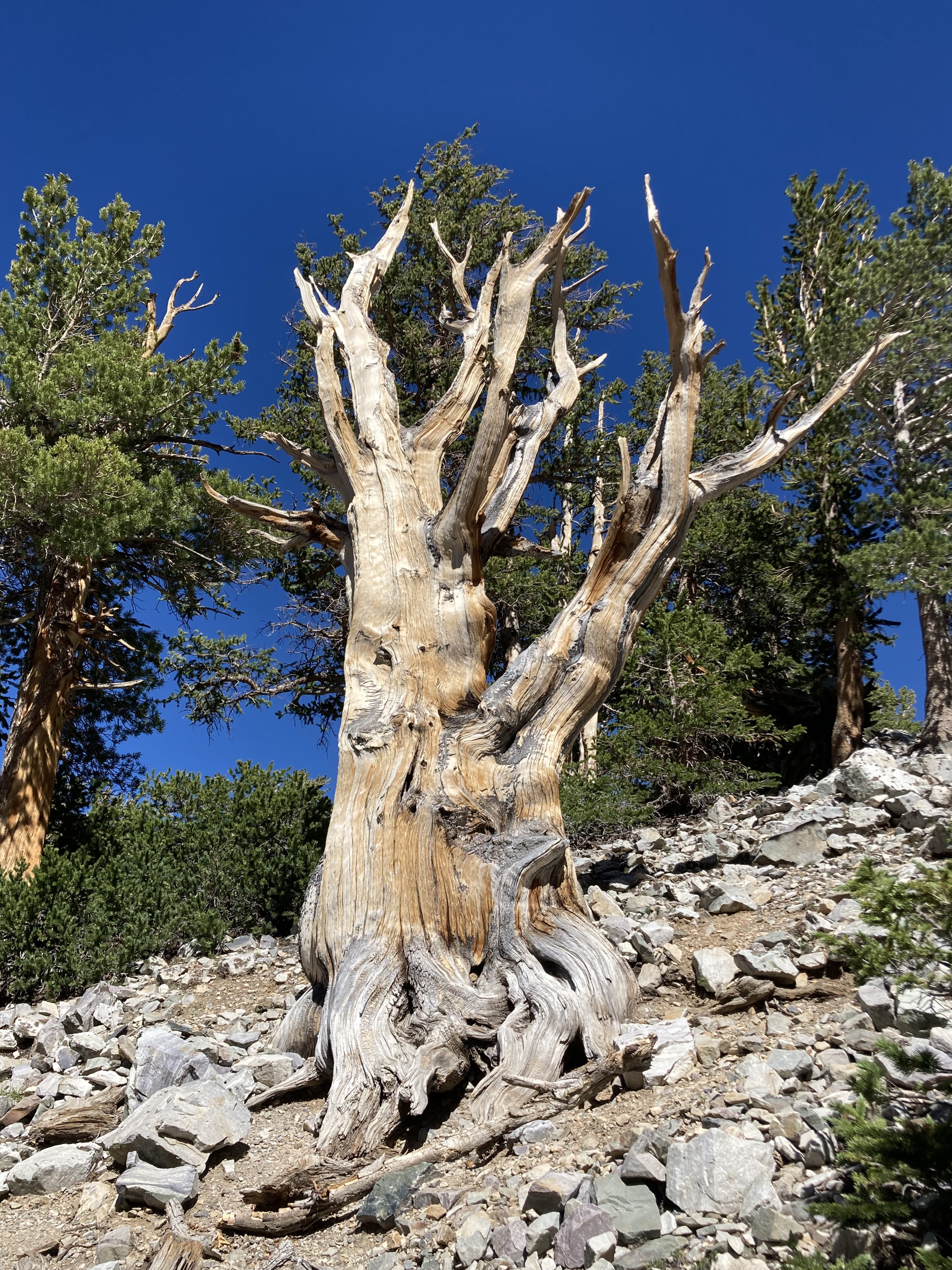
Next is the end of the road at the trailhead for the Bristlecone Trail which I take, it’s a great trail but with very treacherous footing in areas and over 10,000 foot elevation.
After this action, I'm ready to find a camping site but all the park camping areas are by reservation only, so I return to the earlier visited Sacramento BLM campground. First I stop at the Lehman Caves visitors center where there is a store that sells ice cream cones, really good ! The Lehman Caves seem to be the most popular family attraction here as they are world class. I've been to several caves and am not so excited about seeing another one at this time and it requires a reservation.
Next morning, I go to the Baker archeology exhibit which is located a couple of miles outside Baker. It appears to be a dry desolete looking area where no one, would ever want to live in, but 700 years ago, people of the Folsom culture, predecessors of the Anasazi culture had a small cluster of dwellings made of adobe and wood here. It may look dry and desolate now but 700 years ago before the white man arrived and dammed the rivers for irrigation and when the climate may have been wetter, there was a small creek running near the site. Archeology conducted at the site tells us that they grew crops, corn and beans, and hunted game for subsistence. Pottery shards, arrow points, various seeds and animal bones were found during excavation of the site.
 |
| Dwelling outlines, after exaction they were back filled to protect |
I then drive back into Great Basin NP and up to the Wheeler Peak trailhead to do the hike up Mt. Wheeler. It’s not a long hike, 8.6 miles roundtrip, but the last 2 miles up are brutal, steeply uphill in rocks, at high altitude and on this day the wind was blowing at gale force. I did make it slowly, but the upper section was not much fun. This hike has an elevation gain of 2,902 feet, really texting lungs and legs and then coming back on the treacherous rock.
 |
View overlooking lake
|
 |
| Rested at the top in this wind shelter |
 |
| That's the trail up |
 |
| Incredible view |
 |
| Love the Aspen groves back in the tree zone |
I drive out of the park at this point, get onto route 50 heading east stopping at what I thought was basic gas station called the Border Inn as it is adjacent to the Nevada / Utah state line. Once there I found that it was much more, it’s an RV Park, Motel, General Store, Bar, Restaurant and Casino. It also has a great collection of old historical photos of the area, celebrities who have passed through and many local heroes and characters. I actually ate at the restaurant, nice and clean with good service and was very tempted to test my luck on the slots.
I probably could have, should have spent the night in their huge parking lot, but I didn’t. I returned to the road and drove another 50 miles into Utah through some dust storm areas and wild beautiful country to a boring roadside pullout across from Lake Sevier which appeared to be a dry lake bed.
Next stop will be Delta, Utah.


No comments:
Post a Comment