July 3 - 7, 2022:
In the morning I back track 10 miles or so to check out an interesting mountain pass I had come through the previous evening. Of course that means passing through the dust storm area for 6 miles again, although it’s not as windy now. Anyhow it was worth it. I now get back on track heading east on route 50 for the town of Delta, UT. I would have to say that there is nothing of much interest from the highway in this area, but all sorts of adventures await if one were to venture down some of these dusty, bumpy side roads.
 |
| Often difficult to keep my eyes on the road |
 |
| Lots of these unknown to me beautiful flowers |
 |
| This is minor stuff, my lungs are full of dust by this point |
I arrive in Delta, UT looking forward to some civilization, but since it’s a holiday weekend virtually nothing is open and honestly it looks like a nice but a boring town. I go over to the fairgrounds hoping there might be something going on this weekend and the big action is a demolition derby. I rinse the dust off the van at a car wash, stop at the modern convenience store, fuel up and get out my map to see where to go from here. I can't see anything to do here this weekend, so I start searching for alternatives.
I see the town of Fillmore within an hour away just off interstate 15 which has a Pilot Truck stop and looks larger than Delta. It was the territorial capital of Utah at one point and has a museum in the original capital building. There are also national forest lands nearby that could be potential overnight places to disperse camp.
https://en.wikipedia.org/wiki/Fillmore,_Utah
I arrive in Fillmore to see a main street draped with flags, I stop to look around and see a sign giving a list of the 4th of July events. They are going all out in this town, parade, pancake breakfast, a foot race, lots of food concessions, games for the children, music and of course fireworks. I also see a sign for a 70 mile Pahvant Valley Heritage Trail in the area and decide to do part of it for the day.
 |
| A flag covered city hall |
 |
| I liked the motel sign |
 |
| The Avalon seems to be a private residence now, BBQ out front |
 |
| The only bar in town, closed |
 |
| Great Spinning Wheel Motel sign |
The Pahvant tour travels through the historic old town of Deseret, established in 1860, which actually looks pretty sad these days. The original Fort Deseret still exists, but barely with its adobe walls mostly eroded away. I’m surprised that the Mormons have not done more with this site since they are pretty fanatical about their history and achievements. The rest of the tour route takes me through lush green irrigated farm land bordering massive lava flows. This area had substantial volcanic activity with thousands of acres of land totally covered by lava fields.
 |
| The remains of the fort |
 |
| Rock called the "Big Head" that resembles Mormon founder |
 |
| Indian Petroglyph |
 |
| Miles and miles of roads like this |
 |
| Large layers of lava, interesting how it stops here leaving a sharp ledge |
The Love’s Truck Stop is spacious, clean and modern so I spend the night there with the convenance of food, snacks and bathroom.
In the morning, I witness the parade, everyone in town seems to be there, it reminds me a lot about my former home in Hightstown, NJ where I lived on the parade route. I actually was in the parade a couple of years with my 38 Dodge. This parade took an hour, it was very stretched out, but was more of a candy parade, (Halloween again) for the kids as about every parade vehicle was throwing handfuls of candy out for the children. Ironically, there was nothing political, the general message was just a celebration of our freedom in the US, but I thought it unusual that there were no marching military groups or school bands.
 |
| The local leaders |
 |
| They all knew each other |
 |
| The local gas station |
 |
| The general theme of the parade seemed good, but ? |
 |
| The original Territorial Capital of Utah was open to tour |
 |
| Of course Brigham Young's portrait is hanging there |
 |
| Along with dozens of other prominent followers |
 |
| I saw many today who look similar |
Afterwards I finish the tour route to the town of Kanosh, named for Chief Kanosh of the Ute tribe. It is an historic town started in 1867 with approval from chief Kanosh who maintained friendly relations with the Mormons. I find nothing else of interest there, sad to say, so I return to Fillmore. I drive a few minutes outside of town into the Fishlake National Forest where I see where the camping crowd has gone to celebrate the holiday. There are several campsites off the road and it is open to the OHV types. There is a nice open parking area there, but In spite of that I return to the truck stop for the sake of convenience.
 |
| The chief looks Mexican ? |
 |
| The chief had problems with his wives |
In the morning I get a shower at Loves, make an attempt to get an oil change in town (they are too busy) then spend an hour at the library and finally get on the road at noon. I’ve decided to go make a stop at the Cove Fort which turns out to a guided tour event and very interesting. This fort was built in 1867 to protect the Mormon settlers from Indian attack but since the Mormons maintained good relations with the local Indians, there was never any trouble. The fort was built of locally available lava rock with 3 foot thick walls, a very impressive building. It even housed a state of the art (for its time) telegraph station to allow it to communicate to other stations within a 30 mile radius.
 |
| We were told that this is the original door |
 |
| Very comfortable inside |
 |
| Beautiful gardens |
 |
| Interior walls of the fort |
 |
| Incredible stone masonry |
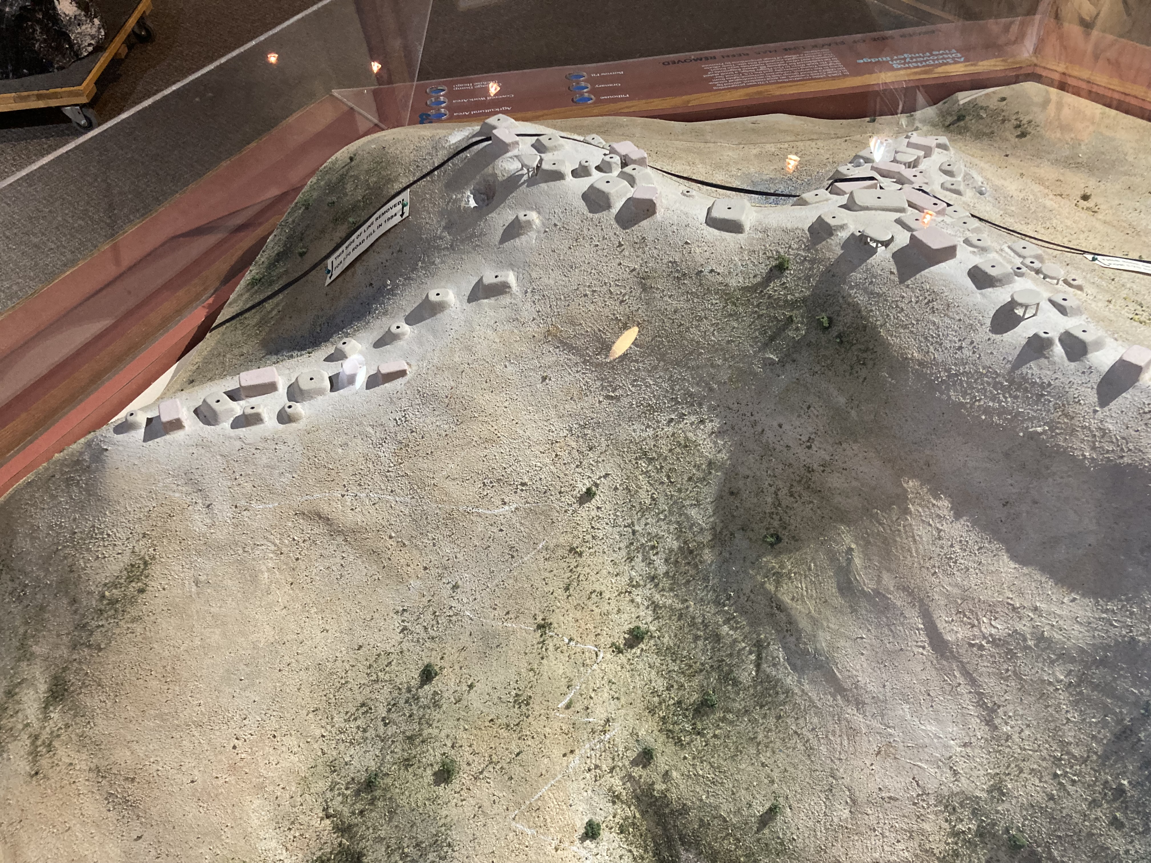
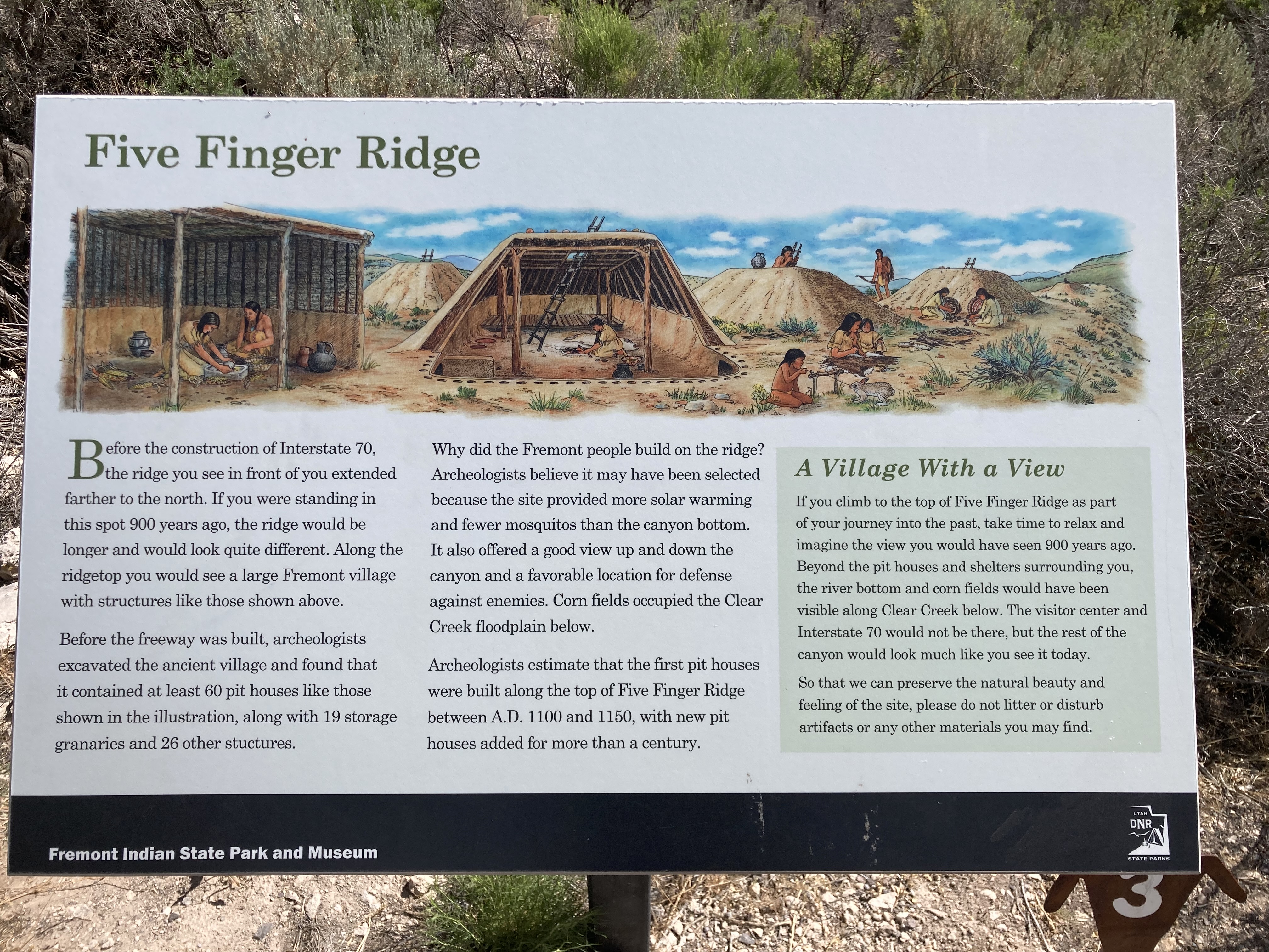
My next stop is the Folsom Indian State Park where I go through their museum which tells the story (as much as is known) about the sizable pit house village that once existed on the hilltop in front of the museum. I say used to exist as a least half of the hillside was removed to build I-70. The highway planners were not aware of this Indian village until construction was well along and changing the path of the highway was then not feasible. A remedial plan was developed to allow archeologists time to research the area and remove as many artifacts as possible and to protect the surrounding land by creating a state park and museum. There are 1,000’s of petroglyphs in this park area and there are several hiking trails to view many of them. The areas rock formations and landscape views are beautiful with or without the petroglyphs.
 |
| Original Fremont pottery |
 |
| Model of the hilltop village |
 |
| Hand prints in the 100 hands cave |
 |
| Have to keep it locked up these days |
 |
| Several Fremont Petroglyphs |
 |
| This is a rather famous one of a steam train done at a later date |
 |
| There str 1,000 of then, but hard to see high up on a rock wall |
 |
| Another noteworthy one that has color which resembles a quilt |
I found a nearby forest service dispersed camping area nearby where I spent a quiet night.
In the morning I returned to look at a few more petroglyphs, then departed and headed on I-70 south to check out the “ Hard Rock Candy Mountain”. I saw this on a map and had no idea what it actually was, but needed to find out. As I drove to it, it actually is a very impressive beautiful mountain view but the attraction is now mostly a resort community. The Denver & Rio Grande Railroad that once ran through this incredibly beautiful mountain / canyon area back in the gold mining days went out of business decades ago. It has recently been turned into a rails to trails project with miles of paved walking and biking trails. Clear Creek also flows along this same path which on this day is flowing very fast, over large boulders looking more like a white water adventure.
 |
| Clear creek |
 |
| It does actually look like it's made of candy |
 |
| The rail history |
 |
| Clear Creek again |
 |
| A retired railcar campground now |
Another 20 miles brings me into Richfield, UT which is a large town with many shopping and restaurant facilities. The Walmart is looking very enticing, it’s been awhile since I stayed in one. My first chore is to get an oil change and there is no line at the jiffy lube, but I can’t believe how the price of an oil change has increased. I may have to start doing my own again. I then find a decent laundromat that has clean looking fairly new Maytag machines and get that unpleasant chore finished. I really don’t feel like cooking at this point so I go to the only place in town that sounds like a bar / cafe called the Bar 86.
https://en.wikipedia.org/wiki/Richfield,_Utah
In the morning, I buy some grocery items at Walmart, then to McDonalds for wifi, then to Maverick for gas, cheapest fuel yet on this trip at 4.98 / gal. I then go off to explore finding an old lime kiln that was operated by a Swedish settler Jens Larson Jenson. It was used to produce the mortar used to construct many of Richfield’s buildings. I see that this area is loaded with bike and off road trail which are part of the huge Paint ATV Trail System. OHV vehicle sales and service is now a thriving business in this area.
 |
| A mind boggling map |
 |
| Unusual car dealer advertisement |
 |
| Jens lead a productive life |
 |
| Historic photos |
 |
| The water wheel |
I take a ride to the neighboring town of Aurora passing an enormous solar array on both sides of I-70, but find nothing of interest in town, it’s basically a farming and residential community. This valley is fully irrigated and lush with farming in contrast to the mostly bare, but beautiful, hillside and mountain vistas surrounding it.
I keep going on the highway to the exit for Salina, UT where I find a mecca for travelers. There is a Dennys, a Maverick, a Loves Truck Stop, a T/A Truck Stop and a couple of motels. A mile down the road is the very cute town of Salina, UT with a nice business district and more restaurants and shops. I mediately see the place I must go for breakfast tomorrow morning, Famous Mom’s Cafe. It turns out the breakfast equaled the rave reviews posted on an interior wall in the restaurant.
https://en.wikipedia.org/wiki/Salina,_Utah
I spend the night in an open lot across from a Travel America Truck Stop which was good except about 3 AM when many trucks started to depart making considerable noise. In the morning, as planned, I go to Mom’s Cafe for breakfast.
 |
| It's famous |
In the morning I’m back on route 70 east across an amazing picture postcard views of Utah, I stop for about every roadside viewpoint and a few unauthorized roadside stops. It’s a beautiful clear day but really hot, close to 100 degrees. I set my destination as Green River, UT, just over 100 miles away. I feel sorry for the vacationing travelers who have a week and are rushing around like crazy to see everything on the run. I’m driving 100 miles and day and feel like I’m rushing it !
 |
| I spent about an hour roaming around here |
Green River is nothing to grab about, mostly a poor house except for the river and it’d history. John Wesley Powell set off from here on his first Colorado River expedition in. The John Wesley Powell Museum is open as I arrive, so I stop for a look, it includes much more than John Wesley, it also has exhibits about the Green River, Indigenous people, early mountain men / trappers and a Hall of fame for people of accomplishment (you might call them river rats) who did remarkable things. Afterwards, I find the seedier park of town, I didn’t think there was one in Utah, but Green River did have one, but it’s about dead now, just as well.
https://en.wikipedia.org/wiki/Green_River,_Utah
 |
| The Spanish Trail runs through here |
 |
| Front of the museum |
Looking at my ultimate campground app (my go to app at the moment), I see that the Crystal Geyser dispersed campsite nearby and following the GPS coordinates I get there. It is an actual geyser, but not like “Old Faithful” it doesn't follow any time schedule. It also (I was told) is not natural, but happened by accident while drilling for a gas well. The site sits just above the Green River and and when it spouts it covers the surrounding area with a very colorful mineral coating which also runs down into the river. I intended to stay the night there until a group of young people arrived and it became apparent to me that it was their usual Friday night hangout spot. As a result, I drive back into town to the truck stop for the night which turned out to be mostly quiet.
 |
| Quite beautiful |
 |
| It erupts out of that pipe |
 |
| Then flows downhill into the Green River |
I must end this segment now, it’s getting out of control, the next stop looks like Moab, UT and Arches National Park.


No comments:
Post a Comment